
Rodebach (Maas)
| Rodebach | ||
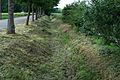
 The Rodebach in Mindergangelt |
||
| Data | ||
| Water code | DE : 221822 | |
| location |
Germany
|
|
| River system | Rhine | |
| Drain over | Vloedgraaf → Geleenbeek → Maas → Holland Diep → North Sea | |
| River basin district | Meuse | |
| source |
Retention basin , Siepenbusch , City of Übach-Palenberg 50 ° 56 ′ 9 ″ N , 6 ° 4 ′ 40 ″ E |
|
| Source height | approx. 105 m above sea level NN | |
| muzzle | in the Geleenbeek in Oud-Roosteren in the Netherlands Coordinates: 51 ° 4 ′ 33 " N , 5 ° 49 ′ 56" E 51 ° 4 ′ 33 " N , 5 ° 49 ′ 56" E |
|
| Mouth height | approx. 29 m above sea level NN | |
| Height difference | approx. 76 m | |
| Bottom slope | approx. 2.6 ‰ | |
| length | about 29 km | |
| Catchment area | 174.385 km² | |
| Left tributaries | Krümmelbach | |
| Right tributaries | Saeffeler Bach | |
The Rodebach (Dutch: Roode Beek ) is a right tributary of the Geleenbeek that runs through the district of Heinsberg ( North Rhine-Westphalia ) and the neighboring Dutch province of Limburg .
history
In the past, the Rodebach was a lifeline for the Selfkant . Together with the Krümmelbach and Saeffeler Bach tributaries, 14 water mills were operated on it between Stahe and Isenbruch . After the Congress of Vienna , the brook became the border between Germany and the Netherlands for long stretches . Today, after the water mills the grinding operation have set, the region endeavored with the 700 hectares comprehensive nature and landscape Park Rodebach / Roode Beek both sides of the border as a destination for eco-tourism.
description
The Rodebach, which once had its source in the Teverener Heide , begins today at a retention basin near the village of Siepenbusch in the town of Übach-Palenberg . The brook with a length of about 29 kilometers flows in a north-westerly direction and is mainly used for surface drainage and for flood protection when ice and snow melt. The course of the stream leads north past Teveren towards Gillrath , where it turns west. On its way, several biotopes and retention basins regulate the even flow of water during floods. In Stahe, the Rodebach at river kilometer 20.8 takes on the two kilometer long Krümmelbach, which drains the airport grounds near Teveren . The further course of the stream is directed to the west, along the villages of Gangelt and Mindergangelt. Here the confluence of the Dutch. Zulaufs, the Roode Beek , which has its origins in the Brunssumer Heide. It continues via Süsterseel before passing the towns of Wehr , Tüddern , Millen and Isenbruch to the north . Shortly before the Isenbruch mill , the 12.5 kilometer long Saeffeler Bach is recorded. At the westernmost point of Germany at 51 ° 3 ' N , 5 ° 52' E , the Rodebach leaves German territory and flows into the Geleenbeek as "Roode Beek" before it flows into the Maas .
maintenance
The care and maintenance of the Rodebach is the responsibility of the respective towns and communities as residents.
- City of Übach-Palenberg for the area: Scherpenseel and Siepenbusch.
- City of Geilenkirchen for the area: Grotenrath , Teveren, Gillrath.
- Gangelt municipality for the area: Niederbusch, Stahe, Gangelt, Mindergangelt.
- Selfkant municipality for the area: Süsterseel, Tüddern, Wehr, Millen and Isenbruch.
Tributaries
- Fleetgraben ( left ), Grotenrath
- Ölgraben ( left ), Gillrath
- Krümmelbach ( left ), with a length of two kilometers
- Ruischerbeekje ( left )
- Roode Beek ( left )
- Huiskensgraaf ( left )
- Etzenradergrub ( left )
- Quabeeksgrub ( left )
- Saeffeler Bach ( right ), with a length of 12.5 kilometers
- Lohgraben ( right )
gallery

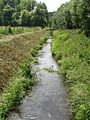
Rodebach in Siepenbusch

Rainwater retention basin

Stream to Grotenrath

Pollard willows between the stream and the path

Rodebach in Grotenrath

Stream regulation and level measurement in Gillrath

Biotope and retention basin

Road crossings in Gillrath
Stream course in front of Stahe

Krümmelbach near Stahe
Rodebach at the Etzenrath mill

near the Millener mills


Former watermills on Rodebach
- Engelsmühle , Rodebachstrasse 33 in Gangelt-Stahe
- Platzmühle , Zur Platzmühle 22 in Gangelt-Stahe
- Mohrenmühle , Zur Mohrenmühle 11 in Gangelt
- Dahlmühle , Zur Dahlmühle 20 in Gangelt
- Brommler Mühle , Schinvelder Straße 51 in Gangelt-Mindergangelt
- Etzenrather Mühle , Etzenrather Mühle in Gangelt-Mindergangelt
- Roermolen , Molenweg in Jabeek (NL)
- Ingentaler Mühle , Pfarrer-Kreins-Straße 6 in Selfkant-Süsterseel
- Istrater Mühle , Istraten in Selfkant-Süsterseel
- Wehrer Mühle , Mühlenstraße 5 in Selfkant-Wehr
- Vollmühle Tüddern , Oligstrasse 35–37 in Selfkant-Tüddern
- Kornmühle Tüddern , Sittarder Strasse 1–3 in Selfkant-Tüddern
- Millener Mühlen , to the Millen house in Selfkant-Millen
- Isenbrucher Mühle , Isenbrucher Mühle in Selfkant-Isenbruch
literature
- Hans Vogt: Lower Rhine water mill guide 2nd edition. Niederrhein Association, Krefeld 1998, ISBN 3-00-002906-0 , pp. 465-466.
- Topographic map 1:50 000 L 5102 Geilenkirchen and L 5000 Selfkant, ISBN 3-89439-417-X
Individual evidence
- ↑ a b Topographic map 1: 25,000
- ↑ Topographical Information Management, Cologne District Government, Department GEObasis NRW ( Notes )
- ↑ Area directory for the water stationing map of the state of North Rhine-Westphalia ( Memento of the original from October 17, 2013 in the Internet Archive ) Info: The archive link was inserted automatically and has not yet been checked. Please check the original and archive link according to the instructions and then remove this notice. (PDF; 556 kB)