
Teverener Heath
|
Teverener Heide nature reserve
|
||
,_Heide_und_Wald,_Naturschutzgebiet_HS-001.jpg) Landscape in the NSG Teverener Heide |
||
| location | Gangelt , Geilenkirchen and Übach-Palenberg , District of Heinsberg , North Rhine-Westphalia , Germany | |
| surface | 4.498 km² | |
| Identifier | HS-001 | |
| WDPA ID | 82707 | |
| Natura 2000 ID | DE-5002-301 | |
| FFH area | 4.479 km² | |
| Geographical location | 50 ° 57 ' N , 6 ° 2' E | |
|
||
| Setup date | 1977 | |
| Framework plan | Landscape plan Teverener Heide | |
| administration | Lower landscape authority district of Heinsberg | |

The Teverener Heide is a nature reserve in the Heinsberg district in North Rhine-Westphalia .
location
The Teverener Heide extends over an area of around 4.5 km² west of the town of Teveren in the southern district of Heinsberg along the German-Dutch border and, together with the nearby nature reserves Rodebach and Brunssummerheide, forms the Heidenaturpark. On the German side, the cities of Geilenkirchen and Übach-Palenberg as well as the municipality of Gangelt border the area that has been part of the Green Metropolis project since 2008 . The city of Brunssum is on the Dutch side .
North of the heath is the NATO airbase Geilenkirchen , the home airfield of the NATO E-3A association with its early warning system AWACS .
history
- 1977 - Designation as a nature reserve
- 2001 - joining the European network "Natura 2000"
- 2003 - Incorporation into the Heidenaturpark with Rodebach and Brunssummerheide
- 2008 - incorporation into the green metropolis
nature
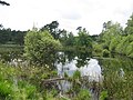
The Teverener Heide captivates with a changing image of heather, moor and forest. In addition, the visitor will find numerous lakes there that were created by the mining of sand and clay in the 20th century. The heather offers a good habitat for many plants and animal species, some of them rare
Moorland pond with cotton grass deposits

Christopherussee in the Teverener Heide

Pine lake in the Teverener Heide

typical birch trees


Visitors
In addition to numerous access options, there are three central parking spaces at the Heiderand:
- Grotenrath (City of Geilenkirchen)
- Scherpenseel (City of Übach-Palenberg)
- Hohenbusch (municipality of Gangelt)
Various color-marked hiking trails, cycle routes and bridle paths lead through the area from the parking lots. Erected lookout points and around a dozen information boards offer the visitor an insight into the untouched nature beyond the paved paths.
See also
Web links
- Nature reserve "HS-001 Teverener Heide" in the specialist information system of the State Office for Nature, Environment and Consumer Protection in North Rhine-Westphalia
- Heidenaturpark
- Green metropolis
Individual evidence
- ↑ The Teverener Heide! A nature reserve right around the corner ... at teveren.info
- ↑ Make one out of three. on: heidenaturpark.de
- ↑ a b The discovery of a new landscape. ( Memento of the original from May 31, 2009 in the Internet Archive ) Info: The archive link was automatically inserted and not yet checked. Please check the original and archive link according to the instructions and then remove this notice. on: gruenmetropole.de
- ↑ a b Teverener Heide: Portrait. on: teverenerheide.de
- ^ Rodebach-Roode Beek: History. on: rodebach.eu