
Roermolen
| Roermolen
|
||
|---|---|---|
 Roermolen in Jabeek |
||
| Location and history | ||
|
||
| Coordinates | 50 ° 58 '58 " N , 5 ° 57' 26" E | |
| Location |
Netherlands
|
|
| Waters | Rodebach | |
| Built | 1492 Mentioned in a border description | |
| Shut down | 1965 End of the mill activity | |
| technology | ||
| use | Oil and grain mill | |
| Grinder | 2 grinding courses 1 oil press | |
| drive | Watermill | |
| water wheel | undershot | |

The Roermolen is a former on Rodebach preferred water mill with an undershot waterwheel in Jabeek in the Dutch municipality Beekdaelen .
geography
The Roermolen is located on the left side of the stream on Molenweg in the Jabeek district in the municipality of Beekdaelen ( Onderbanken until 2018 ), in the Dutch province of Limburg . It is the only mill on the Rodebach that is not on German territory. The area on which the mill building stands has a height of approx. 55 m above sea level . Neighboring mills are above the Etzenrather Mühle , below the Ingentaler Mühle in the municipality of Selfkant .
Waters
Up until the last century, the Rodebach supplied fourteen mills with water. The stream begins at a retention basin near Siepenbusch in the town of Übach-Palenberg at an altitude of 105 m above sea level. The Rodebach has a length of 28.9 km to its confluence with the Geleenbeek near Oud-Roosteren in the Netherlands . The mouth height is 29 m above sea level. The care and maintenance of the Rodebach and its tributaries is subject to the respective neighboring cities and communities. → See also Rodebach
history
The Roermolen is the only one of the fourteen mills on Rodebach that is on Dutch territory today. It was also called the "Jabecker Mühle" because of its close location to Jabeek. In the log of the Lemitengang 1492 "Roers" is given as a topographical point west of the Etzenrath mill. In 1690 there is an entry in the Gangelter church book, according to which Lambert Lamberts had a son in the "Ritzrohr mühl".
Today's listed building shows the year 1794 on the painted gable next to a mill cart. In the courtyard there are still several millstones from a grinding mill and an oil mill from the pan mill . The mill device is no longer available. The grinding operation was discontinued with the Second World War .
gallery
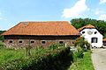
Residential and farm building Roermolen

Ancient mill vehicle

Rodebach near the Roermolen

Tranchot card 1804/05


literature
- Hans Vogt: Lower Rhine water mill guide 2nd edition. Niederrhein Association, Krefeld 1998, ISBN 3-00-002906-0 , pp. 247-248
- Wilhelm Pieper: The last mill wheel on the Rodebach home calendar 1995 Heinsberg district p. 158–164
- State survey office of North Rhine-Westphalia topographic map 1:50 000 L 5102 Geilenkirchen and L 5000 Selfkant, ISBN 3-89439-417-X
Web links
- Website of the Rodebach Landscape Park (German, Dutch)
- Website of the municipality of Beekdaelen (Dutch)