
Talmühle (Dremmen)
| Talmühle (Dremmen)
|
||
|---|---|---|
 |
||
| Location and history | ||
|
||
| Coordinates | 51 ° 2 '28 " N , 6 ° 9' 26" E | |
| Location | Germany | |
| Waters | Worm , boy worm | |
| Built | before 1461 | |
| Shut down | around 1945 | |
| Status | Monument protection | |
| technology | ||
| use | Oil and grinder mill | |
| Grinder | 1 grind 1 oil press | |
| drive | 1 water wheel | |
| water wheel | undershot | |

The valley mill was a watermill on the Junge Wurm . It is located in the town of Heinsberg in the North Rhine-Westphalian district of Heinsberg in the administrative district of Cologne .
geography
The Talmuhle had its location on the boys worm , at the Talmühlenstraße, in the district Dremmen in the town of Heinsberg. The property on which the mill building stands is approx. 49 m above sea level . In front of the mill was a mill pond. Above was the Horster mill in Horst , below was the location of the Liecker mill in Dremmen.
Waters
The Junge Wurm was a body of water that ran more or less parallel to the Wurm . The junction from the Wurm was in Nirm, a district of the city of Geilenkirchen . Here the worm has a height of 54 m above sea level. The river Junge Wurm, also known as the Kleine Wurm , flowed in a north-northwest direction via Randerath , Horst , Porselen , Dremmen , Grebben , Heinsberg , Kempen and Karken across the German - Dutch border towards Vlodrop and empties at an altitude of 29 m above sea level on Dutch territory into the Rur . It was a natural body of water in which humans had a hand in many places. The Junge Wurm was connected to the Heinsberg moat , the mill canal, the Liecker brook and the mill brook . This composite body of water served for surface drainage and the benefit of the people. For centuries there were around 15 water mills on the Junge Wurm, with a slope of 26 m between Randerath and Karken. With the worm straightening in the 1960s and 1970s, the young worm disappeared from the maps . Instead, drainage channels and trenches were created. The water association Eifel-Rur (WVER) is responsible for the care and maintenance of the water body with a catchment area of 355.518 km 2 .
history
The sovereign oil mill was first mentioned in 1461. She had to deliver 25 quarts of oil (about 22 liters) to the Duchy of Jülich every year . In 1806 the oil mill, which was equipped with a mill ban , was converted into a grinding mill with two water wheels and two grinding stages by the Horster millers family Lambertz . The mill worked until January 1945; then significant parts of Dremmen and Heinsberg were destroyed by Western Allied air strikes and artillery shells as part of Operation Peacock .
The mill building and a water wheel were preserved; they are under monument protection .
Monument entry
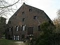
Talmühle Dremmen Hof und Mühle : Four- winged brick courtyard, main building has two floors with three axes, mansard roof , gable side with three to four axes. Stem with mill wheel. From the first half of the 18th century, wooden door from the end of the 18th century, two-storey, three-wing half-timbered structure - forecourt. Entry in the list of monuments on January 16, 1984.
gallery

Residence of the Talmühle in Dremmen
Economic section of the valley mill in Dremmen

Water wheel with wheel house of the valley mill
Talmühle as Görtzmühle on the first recording from 1843

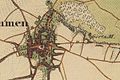
Talmühle and Junge Wurm on the new recording from 1893

Talmühle on the Tranchot map 1806/1807


See also
literature
- Hans Vogt: Lower Rhine water mill guide 2nd edition. Verein Niederrhein, Krefeld 1998, ISBN 3-00-002906-0 , pages 305-306.
Web links
Footnotes
- ^ German basic map 1: 5000
- ↑ Archived copy ( memento of the original from October 17, 2013 in the Internet Archive ) Info: The archive link was inserted automatically and has not yet been checked. Please check the original and archive link according to the instructions and then remove this notice.
- ↑ http://www.wver.de/
- ↑ Photos and text
At the worm :
Beeretz mill |
Bommers Mill |
Frelenberger Mill |
Horriger Mill |
Hünshovener oil mill |
Grinder and Oil Mill Trips |
Marienthaler Mill |
Müllendorfer mill |
Lohmühle |
Lohmühle |
Eichenthal Mill |
Mill Hommerschen |
Oil and paper mill Oberbruch |
Porselener Mill |
Randerather oil mill |
Rimburg mills |
Süggerather mill |
Interrupt mill |
Full mill interruption |
Zweibrügger Mühle
An der Junge Wurm:
Aldenhover Mühle |
Brünkers Mill |
Dahlmühle |
Horster mill |
Karker Mill |
Kemper Mill |
Lambertz Mill |
Liecker mill |
Powder mill ] |
Schafhausen grain mill |
Schafhausen oil mill |
Town mill |
Valley mill |
Wolfhager Mühle
Am Rodebach :
Brommler Mühle |
Dahlmühle |
Angel Mill |
Etzenrather mill |
Ingentaler Mill |
Isenbruch Mill |
Istrater mill |
Tüddern grain mill |
Millener mills |
Mohrenmühle |
Square mill |
Vollmühle Tüddern |
Wehrer Mühle
An der Schwalm :
Bischofsmühle |
Post mill |
Kornmühle Tüschenbroich |
Kringsmühle |
Lohmühle |
Neumühle |
Oil mill Tüschenbroich |
Rossmühle |
Wegberger Mühle
Am Mühlenbach :
Buschmühle |
Holtmühle |
Meismühle |
Molz mill |
Schrofmühle
Am Helpensteiner Bach:
Dalheimer Mühle |
Helpensteiner Mill |
Rödgener Mühle
Am Beeckbach :
Ophover Mühle
Am Kitschbach :
Kitscher Mühle
Am Knippertzbach :
Knippertzmühle
Am Uebach :
Übacher Mühle