
Brünkers Mill
| Brünkers Mill
|
||
|---|---|---|
 This was the location of the Brünkers mill |
||
| Location and history | ||
|
||
| Coordinates | 51 ° 1 '8 " N , 6 ° 10' 37" E | |
| Location | Germany | |
| Waters | Worm , boy worm | |
| Built | 1849 | |
| Shut down | around 1936 | |
| technology | ||
| use | mechanical rough-mill , wage and grain mill | |
| Grinder | 1 grind | |
| drive | 1 water wheel | |
| water wheel | undershot | |

The Brünkers Mühle was a watermill on the Junge Wurm in the city of Heinsberg in the North Rhine-Westphalian district of Heinsberg in the administrative district of Cologne .
geography
The Brünkers Mühle was located on the Junge Wurm , on the Driesch, in the Randerath district in the town of Heinsberg. The plot of land on which the mill building stood is approx. 53 m above sea level . Above stood the Lambertz mill, below the Horster mill.
Waters
The Junge Wurm was a body of water that ran more or less parallel to the Wurm . The junction from the Wurm was in Nirm, a district of the city of Geilenkirchen . Here the worm has a height of 54 m above sea level. The river Junge Wurm, also known as the Kleine Wurm , flowed in a north-northwest direction via Randerath, Horst , Porselen , Dremmen , Grebben , Heinsberg , Kempen and Karken across the German-Dutch border towards Vlodrop and empties at an altitude of 29 m above sea level on Dutch territory into the Rur . It was a natural body of water in which humans had a hand in many places. The Junge Wurm was connected to the Heinsberg moat, the mill canal, the Liecker brook and the mill brook . This composite body of water served for surface drainage and the benefit of the people. For centuries there were around 15 water mills on the Junge Wurm, with a slope of 26 m between Randerath and Karken. With the worm straightening in the 1960s and 1970s, the young worm disappeared from the maps. Instead, drainage channels and trenches were created. The water association Eifel-Rur (WVER) is responsible for the care and maintenance of the water body with a catchment area of 355.518 km 2 .
history
The production of textile fabrics was of great importance for the people in Randerath. In 1843, around 300 weavers worked in three companies. In order to roughen the woven cloth , the brothers Mathias and Anton Brünkers built and maintained a mechanical roughing plant on the Driesch , which powered a water wheel with 20 hp. Over the years, the textile industry moved to Mönchengladbach and Rheydt . The mill was put to another use by producing tanneries . Grain was also ground later. In 1936 the mill was shut down and closed down. Today a replica mill wheel on the new house reminds of the former mill.
gallery

The worm in the locality of Randerath
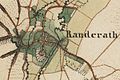
Randerath on the first recording from 1846
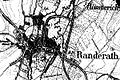
Randerath on the new recording from 1892

Randerath on the tranchot card 1805/1807


literature
- Hans Vogt: Lower Rhine water mill guide 2nd edition. Verein Niederrhein, Krefeld 1998, ISBN 3-00-002906-0 , pages 305.
- Ms. Haubrock: The mills of the former Randerath office, home calendar of the Selfkant district Geilenkirchen-Heinsberg 1961, pages 25–29.
→ See also the list of mills on the Wurm
Web links
Individual evidence
- ^ German basic map 1: 5000
- ↑ Archive link ( Memento of the original from October 17, 2013 in the Internet Archive ) Info: The archive link was inserted automatically and has not yet been checked. Please check the original and archive link according to the instructions and then remove this notice.
- ↑ http://www.wver.de/
At the worm :
Beeretz mill |
Bommers Mill |
Frelenberger Mill |
Horriger Mill |
Hünshovener oil mill |
Grinder and Oil Mill Trips |
Marienthaler Mill |
Müllendorfer mill |
Lohmühle |
Lohmühle |
Eichenthal Mill |
Mill Hommerschen |
Oil and paper mill Oberbruch |
Porselener Mill |
Randerather oil mill |
Rimburg mills |
Süggerather mill |
Interrupt mill |
Full mill interruption |
Zweibrügger Mühle
An der Junge Wurm:
Aldenhover Mühle |
Brünkers Mill |
Dahlmühle |
Horster mill |
Karker Mill |
Kemper Mill |
Lambertz Mill |
Liecker mill |
Powder mill ] |
Schafhausen grain mill |
Schafhausen oil mill |
Town mill |
Valley mill |
Wolfhager Mühle
Am Rodebach :
Brommler Mühle |
Dahlmühle |
Angel Mill |
Etzenrather mill |
Ingentaler Mill |
Isenbruch Mill |
Istrater mill |
Tüddern grain mill |
Millener mills |
Mohrenmühle |
Square mill |
Vollmühle Tüddern |
Wehrer Mühle
An der Schwalm :
Bischofsmühle |
Post mill |
Kornmühle Tüschenbroich |
Kringsmühle |
Lohmühle |
Neumühle |
Oil mill Tüschenbroich |
Rossmühle |
Wegberger Mühle
Am Mühlenbach :
Buschmühle |
Holtmühle |
Meismühle |
Molz mill |
Schrofmühle
Am Helpensteiner Bach:
Dalheimer Mühle |
Helpensteiner Mill |
Rödgener Mühle
Am Beeckbach :
Ophover Mühle
Am Kitschbach :
Kitscher Mühle
Am Knippertzbach :
Knippertzmühle
Am Uebach :
Übacher Mühle