
Kemper mill
| Kemper mill
|
||
|---|---|---|
 The Kemper Mill in Heinsberg-Kempen |
||
| Location and history | ||
|
||
| Coordinates | 51 ° 5 '40 " N , 6 ° 5' 32" E | |
| Location | Germany | |
| Waters | Worm , boy worm | |
| Built | before 1462 | |
| Shut down | Mid 20th century | |
| Status | Monument protection | |
| technology | ||
| use | Oil and grinder mill | |
| Grinder | 1 grind 1 oil press | |
| drive | 2 water wheels from 1891 turbine | |
| water wheel | undershot | |

The Kemper Mühle was a watermill on the Junge Wurm , in the town of Heinsberg in the North Rhine-Westphalian district of Heinsberg in the administrative district of Cologne .
geography
The Kemper mill had its location on the right side of the boys worm , the mill stream, on the upper road 133, in the district of Kempen , in the town of Heinsberg. The property on which the mill building is located has a height of approx. 33 m above sea level . The neighboring mill is the Karker mill , which is only a few hundred meters away.
Waters
The Junge Wurm was a body of water that ran more or less parallel to the Wurm . The junction from the Wurm was in Nirm, a district of the city of Geilenkirchen . Here the worm has a height of 54 m above sea level. The river Junge Wurm, also known as the Kleine Wurm , flowed in a north-northwest direction via Randerath , Horst , Porselen , Dremmen , Grebben , Heinsberg , Kempen and Karken across the German - Dutch border towards Vlodrop and empties at an altitude of 29 m above sea level on Dutch territory into the Rur . It was a natural body of water in which humans had a hand in many places. The Junge Wurm was connected to the Heinsberg moat , the mill canal, the Liecker brook and the mill brook . This composite body of water served for surface drainage and the benefit of the people. For centuries there were around 15 water mills on the Junge Wurm, with a slope of 26 m between Randerath and Karken. With the worm straightening in the 1960s and 1970s, the young worm disappeared from the maps . Instead, drainage channels and trenches were created. The water association Eifel-Rur (WVER) is responsible for the care and maintenance of the water body with a catchment area of 355.518 km 2 .
history
The sovereign Kemper Mill was a forced mill for the village of Kempen. The relatively small banned area was therefore only occupied with a small lease . In the first documentary mention in 1462, the lease was determined to be 15 Malter rye and 40 quart (about 46 liters) of oil. In 1891 the two water wheels were replaced by a turbine . After the creek was relocated in 1938, the system switched to electric drive. The flour mill was still running in the middle of the 20th century. Oil production was stopped at the end of the 19th century. The mill buildings from 1795 are still preserved and inhabited.
Monument entry
Kemper Mill In the 18th / 19th century the old Kempen mill at the mill ditch of the "Junge Wurm" was renewed. The facility, located on Oberstrasse in Kempen, was built in the form of residential stables as a two-storey five-axis wing structure . At the back the living part was two, and the mill part was also biaxial. The gable side received three partially walled-up windows in the gable triangle and four walled-up windows on the upper floor, one of which was in the axis of the former grain elevator on the back side. On the first floor there were two small windows that frame the walled-up axle hole of the mill wheel shaft.
The mill section and the living area are separated by a fire gable and covered by a gable roof between the protruding gable walls . The stichbogigen windows have natural wedge stones and -ankersteine for the clamp of the formerly existing shutters . A single-storey coach house extension was connected at right angles to the mill . Entry in the list of monuments on February 16, 1989.
gallery

Garden side of the Kemper mill

Business section of the Kemper Mühle

Walled up axle hole for the mill wheel shaft
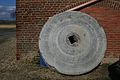
Millstone of a pan mill at the Kemper mill
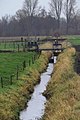
Today's watercourse near the Kemper mill

Kemper Mühle am Mühlenbach on the first recording from 1843

Kemper Mühle am Mühlenbach on the new recording from 1893

Kemper Mühle on the tranchot card 1806/1807


literature
- Hans Vogt: Lower Rhine water mill guide 2nd edition. Verein Niederrhein, Krefeld 1998, ISBN 3-00-002906-0 , pages 305-306.
→ See also the list of mills on the Wurm
Web links
Individual evidence
- ^ German basic map 1: 5000
- ↑ Archived copy ( memento of the original from October 17, 2013 in the Internet Archive ) Info: The archive link was inserted automatically and has not yet been checked. Please check the original and archive link according to the instructions and then remove this notice.
- ↑ http://www.wver.de/
At the worm :
Beeretz mill |
Bommers Mill |
Frelenberger Mill |
Horriger Mill |
Hünshovener oil mill |
Grinder and Oil Mill Trips |
Marienthaler Mill |
Müllendorfer mill |
Lohmühle |
Lohmühle |
Eichenthal Mill |
Mill Hommerschen |
Oil and paper mill Oberbruch |
Porselener Mill |
Randerather oil mill |
Rimburg mills |
Süggerather mill |
Interrupt mill |
Full mill interruption |
Zweibrügger Mühle
An der Junge Wurm:
Aldenhover Mühle |
Brünkers Mill |
Dahlmühle |
Horster mill |
Karker Mill |
Kemper Mill |
Lambertz Mill |
Liecker mill |
Powder mill ] |
Schafhausen grain mill |
Schafhausen oil mill |
Town mill |
Valley mill |
Wolfhager Mühle
Am Rodebach :
Brommler Mühle |
Dahlmühle |
Angel Mill |
Etzenrather mill |
Ingentaler Mill |
Isenbruch Mill |
Istrater mill |
Tüddern grain mill |
Millener mills |
Mohrenmühle |
Square mill |
Vollmühle Tüddern |
Wehrer Mühle
An der Schwalm :
Bischofsmühle |
Post mill |
Kornmühle Tüschenbroich |
Kringsmühle |
Lohmühle |
Neumühle |
Oil mill Tüschenbroich |
Rossmühle |
Wegberger Mühle
Am Mühlenbach :
Buschmühle |
Holtmühle |
Meismühle |
Molz mill |
Schrofmühle
Am Helpensteiner Bach:
Dalheimer Mühle |
Helpensteiner Mill |
Rödgener Mühle
Am Beeckbach :
Ophover Mühle
Am Kitschbach :
Kitscher Mühle
Am Knippertzbach :
Knippertzmühle
Am Uebach :
Übacher Mühle