
Horriger mill
| Horriger mill
|
||
|---|---|---|
 Horriger mill in Geilenkirchen |
||
| Location and history | ||
|
||
| Coordinates | 50 ° 58 '33 " N , 6 ° 8' 25" E | |
| Location | Germany | |
| Waters | worm | |
| Built | 1830 | |
| Shut down | around 1910 | |
| technology | ||
| use | Tire and oil mill | |
| Grinder | 1 grind 1 oil press | |
| drive | 2 water wheels | |
| water wheel | undershot | |

The Horriger Mühle was a water mill with two undershot water wheels on the Wurm in the city of Geilenkirchen in the North Rhine-Westphalian district of Heinsberg in the administrative district of Cologne .
geography
The Horriger mill had its location on the left side of the worm at Good Horrig in the town of Geilenkirchen. The property on which the mill building stands today is approx. 69 m above sea level . Above were the Tripser mills, below the Süggerather mill .
Waters
The worm supplied numerous mills with water over a river length of 53 km. The source of the worm is south of Aachen at 265 m above sea level. The confluence with the Rur is in the town of Kempen in the town of Heinsberg at 32 m above sea level. In the late 1960s and early 1970s, worm straightening was carried out. The curving, now and then meandering course of the river disappeared in favor of a simple route . The river length shortened and the flow speed increased. For many people the flood protection improved , for the mills it was the end. The water association Eifel-Rur (WVER) is responsible for the care and maintenance of the water body with a catchment area of 355.518 km 2 .
history
The year of construction of the Horriger mill is given as 1830. The mill worked with two undershot water wheels, but had constant difficulties due to the slight incline from the Tripser mills with only four feet . The wage and oil mill was closed in 1910. The stately mill building was converted into a residential building and will be preserved for posterity.
gallery
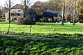
Horriger mill with farm building in the Wurmtal

The wall vault shows where the wheel axle was once

The worm near the Horriger Mühle

Horriger Mühle on the first recording from 1846

Horriger mill on the new recording from 1892
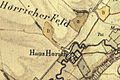
Haus Horrig on the tranchot card 1805/1807


literature
- Hans Vogt: Lower Rhine water mill guide 2nd edition. Verein Niederrhein, Krefeld 1998, ISBN 3-00-002906-0 , pages 291.
→ See also the list of mills on the Wurm
Web links
Individual evidence
- ^ German basic map 1: 5000
- ↑ Topographical Information Management, Cologne District Government, Department GEObasis NRW ( Notes )
- ↑ Archive link ( Memento from October 17, 2013 in the Internet Archive )
- ↑ http://www.wver.de/
At the worm :
Beeretz mill |
Bommers Mill |
Frelenberger Mill |
Horriger Mill |
Hünshovener oil mill |
Grinder and Oil Mill Trips |
Marienthaler Mill |
Müllendorfer mill |
Lohmühle |
Lohmühle |
Eichenthal Mill |
Mill Hommerschen |
Oil and paper mill Oberbruch |
Porselener Mill |
Randerather oil mill |
Rimburg mills |
Süggerather mill |
Interrupt mill |
Full mill interruption |
Zweibrügger Mühle
An der Junge Wurm:
Aldenhover Mühle |
Brünkers Mill |
Dahlmühle |
Horster mill |
Karker Mill |
Kemper Mill |
Lambertz Mill |
Liecker mill |
Powder mill ] |
Schafhausen grain mill |
Schafhausen oil mill |
Town mill |
Valley mill |
Wolfhager Mühle
Am Rodebach :
Brommler Mühle |
Dahlmühle |
Angel Mill |
Etzenrather mill |
Ingentaler Mill |
Isenbruch Mill |
Istrater mill |
Tüddern grain mill |
Millener mills |
Mohrenmühle |
Square mill |
Vollmühle Tüddern |
Wehrer Mühle
An der Schwalm :
Bischofsmühle |
Post mill |
Kornmühle Tüschenbroich |
Kringsmühle |
Lohmühle |
Neumühle |
Oil mill Tüschenbroich |
Rossmühle |
Wegberger Mühle
Am Mühlenbach :
Buschmühle |
Holtmühle |
Meismühle |
Molz mill |
Schrofmühle
Am Helpensteiner Bach:
Dalheimer Mühle |
Helpensteiner Mill |
Rödgener Mühle
Am Beeckbach :
Ophover Mühle
Am Kitschbach :
Kitscher Mühle
Am Knippertzbach :
Knippertzmühle
Am Uebach :
Übacher Mühle