
Müllendorfer mill
| Müllendorfer mill
|
||
|---|---|---|
.jpg) The mill once belonged to Leerodt Castle |
||
| Location and history | ||
|
||
| Coordinates | 50 ° 59 '19 " N , 6 ° 9' 59" E | |
| Location | Germany | |
| Waters | worm | |
| Built | 15th century | |
| Shut down | around 1965 | |
| technology | ||
| use | Grinding mill | |
| Grinder | 1 grind | |
| drive | 1 water wheel | |
| water wheel | undershot | |

The Müllendorfer Mühle was a water mill with an undershot water wheel on the Wurm in the city of Geilenkirchen in the North Rhine-Westphalian district of Heinsberg in the administrative district of Cologne .
geography
The Müllendorfer Mühle was located on the left side of the Wurm, on Mühlenstrasse, in the Müllendorf district, in the city of Geilenkirchen. The property on which the mill building stood is approx. 61 m above sea level . The Süggerath mill was located above, the Randerather oil mill and the Bommers mill in Randerath were below .
Waters
The worm supplied numerous mills with water over a river length of 53 km. The source of the worm is south of Aachen at 265 m above sea level. The confluence with the Rur is in the town of Kempen in the town of Heinsberg at 32 m above sea level. In the late 1960s and early 1970s, worm straightening was carried out. The curving, now and then meandering course of the river disappeared in favor of a simple route . The river length shortened and the flow speed increased. For many people the flood protection improved , for the mills it was the end. The water association Eifel-Rur (WVER) is responsible for the care and maintenance of the water body with a catchment area of 355.518 km 2 .
history
The first written mention of the place Müllendorf goes back to the year 1510 and is Moellendorp . There is disagreement as to whether the place was named after the mill or the village on the mill stream was meant. The mill was the only building belonging to the Lords of Randerath next to the Lehnshof . In the 17th century, Leerodt Castle , the Lehnshof and the mill were in the hands of the Lords of Leerodt, who were followers of the Duke of Jülich . After the death of the last gentleman from Leerodt, the mill was given into private hands in 1869. The undershot water wheel drove a grinding mill, which was last operated with an electric drive until 1965. Only one pillar of the entrance gate remains from the mill .
gallery

This pillar is the rest of the mill
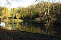
Today's pond near the former mill
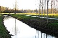
The worm near Müllendorf

Müllendorf on the first recording from 1846
The Müllendorfer mill on the new recording from 1892

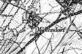
The Müllendorfer mill on the tranchot card 1805/1807


literature
- Hans Vogt: Lower Rhine water mill guide 2nd edition. Verein Niederrhein, Krefeld 1998, ISBN 3-00-002906-0 , pages 293.
- Ms. Haubrock: The mills of the former Randerath office, home calendar of the Selfkant district Geilenkirchen-Heinsberg 1961, pages 25–29.
→ See also the list of mills on the Wurm
Web links
Individual evidence
- ^ German basic map 1: 5000
- ↑ Topographical Information Management, Cologne District Government, Department GEObasis NRW ( Notes )
- ↑ Archived copy ( memento of the original from October 17, 2013 in the Internet Archive ) Info: The archive link was inserted automatically and has not yet been checked. Please check the original and archive link according to the instructions and then remove this notice.
- ↑ http://www.wver.de/
At the worm :
Beeretz mill |
Bommers Mill |
Frelenberger Mill |
Horriger Mill |
Hünshovener oil mill |
Grinder and Oil Mill Trips |
Marienthaler Mill |
Müllendorfer mill |
Lohmühle |
Lohmühle |
Eichenthal Mill |
Mill Hommerschen |
Oil and paper mill Oberbruch |
Porselener Mill |
Randerather oil mill |
Rimburg mills |
Süggerather mill |
Interrupt mill |
Full mill interruption |
Zweibrügger Mühle
An der Junge Wurm:
Aldenhover Mühle |
Brünkers Mill |
Dahlmühle |
Horster mill |
Karker Mill |
Kemper Mill |
Lambertz Mill |
Liecker mill |
Powder mill ] |
Schafhausen grain mill |
Schafhausen oil mill |
Town mill |
Valley mill |
Wolfhager Mühle
Am Rodebach :
Brommler Mühle |
Dahlmühle |
Angel Mill |
Etzenrather mill |
Ingentaler Mill |
Isenbruch Mill |
Istrater mill |
Tüddern grain mill |
Millener mills |
Mohrenmühle |
Square mill |
Vollmühle Tüddern |
Wehrer Mühle
An der Schwalm :
Bischofsmühle |
Post mill |
Kornmühle Tüschenbroich |
Kringsmühle |
Lohmühle |
Neumühle |
Oil mill Tüschenbroich |
Rossmühle |
Wegberger Mühle
Am Mühlenbach :
Buschmühle |
Holtmühle |
Meismühle |
Molz mill |
Schrofmühle
Am Helpensteiner Bach:
Dalheimer Mühle |
Helpensteiner Mill |
Rödgener Mühle
Am Beeckbach :
Ophover Mühle
Am Kitschbach :
Kitscher Mühle
Am Knippertzbach :
Knippertzmühle
Am Uebach :
Übacher Mühle