
Schafhausen oil mill
| Schafhausen oil mill
|
||
|---|---|---|
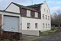
 The Schafhausen oil mill, now a residential building |
||
| Location and history | ||
|
||
| Coordinates | 51 ° 3 '15 " N , 6 ° 7' 2" E | |
| Location | Germany | |
| Waters | Worm , boy worm | |
| Built | 15th century | |
| Shut down | around 1920 | |
| technology | ||
| use | Oil and grinder mill | |
| Grinder | 1 grind 1 oil press | |
| drive | 1 water wheel | |
| water wheel | undershot | |

The Schafhausen oil mill was a water mill on the Junge Wurm , in the city of Heinsberg in the North Rhine-Westphalian district of Heinsberg in the administrative district of Cologne .
geography
The sheep Hausener oil mill had its location on the boys worm , on Torfbruch, in the district Schafhausen in town Heinsberg. The property on which the mill building stands has a height of approx. 43 m above sea level . Above was the Liecker mill , below is the location of the Schafhausen grain mill .
Waters
The Junge Wurm was a body of water that ran more or less parallel to the Wurm . The junction from the Wurm was in Nirm, a district of the city of Geilenkirchen . Here the worm has a height of 54 m above sea level. The river Junge Wurm, also known as the Kleine Wurm , flowed in a north-northwest direction via Randerath , Horst , Porselen , Dremmen , Grebben , Heinsberg , Kempen and Karken across the German - Dutch border towards Vlodrop and empties at an altitude of 29 m above sea level on Dutch territory into the Rur . It was a natural body of water in which humans had a hand in many places. The Junge Wurm was connected to the Heinsberg moat , the mill canal, the Liecker brook and the mill brook . This composite body of water served for surface drainage and the benefit of the people. For centuries there were around 15 water mills on the Junge Wurm, with a slope of 26 m between Randerath and Karken. With the worm straightening in the 1960s and 1970s, the young worm disappeared from the maps . Instead, drainage channels and trenches were created. The water association Eifel-Rur (WVER) is responsible for the care and maintenance of the water body with a catchment area of 355.518 km 2 .
history
The Schafhausen oil mill from the 15th century was on the Schafhausen break. In the 18th century, the sovereigns had to pay an annual rent of 40 quarts (about 46 liters) of oil. In the last years of its existence the mill also served as a grinding mill . The front garden of the house and the farm buildings are evidence of this era . Mill operations were stopped around 1920.
gallery
Residence of the Schafhausen oil mill
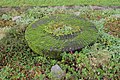
Old millstone in the front yard

Contemporary witness from old times at the Schafhausen oil mill
Schafhausen oil mill on the first recording from 1843

Schafhausen oil mill on the new recording from 1893

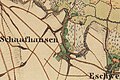
Schafhausen oil mill on the tranchot card 1806/1807


literature
- Hans Vogt: Lower Rhine water mill guide 2nd edition. Verein Niederrhein, Krefeld 1998, ISBN 3-00-002906-0 , page 309.
- Heinrich Tischelbäcker: The Heinsberger Mühlenkanal home calendar of the Selfkantkreis Geilenkirchen-Heinsberg 1962, page 128-134, 1963, page 142-144.
→ See also the list of mills on the Wurm
Web links
Individual evidence
- ^ German basic map 1: 5000
- ↑ Archived copy ( memento of the original from October 17, 2013 in the Internet Archive ) Info: The archive link was inserted automatically and has not yet been checked. Please check the original and archive link according to the instructions and then remove this notice.
- ↑ http://www.wver.de/
At the worm :
Beeretz mill |
Bommers Mill |
Frelenberger Mill |
Horriger Mill |
Hünshovener oil mill |
Grinder and Oil Mill Trips |
Marienthaler Mill |
Müllendorfer mill |
Lohmühle |
Lohmühle |
Eichenthal Mill |
Mill Hommerschen |
Oil and paper mill Oberbruch |
Porselener Mill |
Randerather oil mill |
Rimburg mills |
Süggerather mill |
Interrupt mill |
Full mill interruption |
Zweibrügger Mühle
An der Junge Wurm:
Aldenhover Mühle |
Brünkers Mill |
Dahlmühle |
Horster mill |
Karker Mill |
Kemper Mill |
Lambertz Mill |
Liecker mill |
Powder mill ] |
Schafhausen grain mill |
Schafhausen oil mill |
Town mill |
Valley mill |
Wolfhager Mühle
Am Rodebach :
Brommler Mühle |
Dahlmühle |
Angel Mill |
Etzenrather mill |
Ingentaler Mill |
Isenbruch Mill |
Istrater mill |
Tüddern grain mill |
Millener mills |
Mohrenmühle |
Square mill |
Vollmühle Tüddern |
Wehrer Mühle
An der Schwalm :
Bischofsmühle |
Post mill |
Kornmühle Tüschenbroich |
Kringsmühle |
Lohmühle |
Neumühle |
Oil mill Tüschenbroich |
Rossmühle |
Wegberger Mühle
Am Mühlenbach :
Buschmühle |
Holtmühle |
Meismühle |
Molz mill |
Schrofmühle
Am Helpensteiner Bach:
Dalheimer Mühle |
Helpensteiner Mill |
Rödgener Mühle
Am Beeckbach :
Ophover Mühle
Am Kitschbach :
Kitscher Mühle
Am Knippertzbach :
Knippertzmühle
Am Uebach :
Übacher Mühle