
Knippertzbach
| Knippertzbach | ||
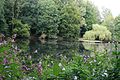
 Rainwater retention basin on the Knippertzbach |
||
| Data | ||
| Water code | EN : 2846 | |
| location | District of Heinsberg , District of Viersen , City of Mönchengladbach , North Rhine-Westphalia , Germany | |
| River system | Rhine | |
| Drain over | Schwalm → Maas → Hollands Diep → North Sea | |
| River basin district | Meuse | |
| source | The stream begins on Broicher Strasse in Mönchengladbach - Rheindahlen , district Broich 51 ° 9 ′ 12 ″ N , 6 ° 21 ′ 8 ″ E |
|
| Source height | 70 m above sea level NN | |
| muzzle | near Schwaam in the Schwalm Coordinates: 51 ° 10 ′ 32 ″ N , 6 ° 16 ′ 46 ″ E 51 ° 10 ′ 32 ″ N , 6 ° 16 ′ 46 ″ E |
|
| Mouth height | approx. 61 m above sea level NN | |
| Height difference | approx. 9 m | |
| Bottom slope | approx. 1.3 ‰ | |
| length | 6.7 km | |
| Catchment area | 22.01 km² | |
The Knippertzbach is a right backwater of the Schwalm .
geography
In the course of the stream, the Knippertzbach touches the districts of Rheindahlen , Broich , Koch , Genhodder and Peel of the city of Mönchengladbach . The Hellbach tributary flows from the Leloh district in Schwalmtal , Viersen district , into the Knippertzbach. In the mouth area, the district of Heinsberg is adjacent to the stream. In this so-called tri- border region, the Düsseldorf administrative region and the Cologne administrative region border one another. The Knippertzmühle once stood at their intersection .
description
The Knippertzbach with a length of 6705 meters, which begins in the river map in Rheindahlen on Broicher Straße, flows into the Schwalm near Schwaam . The beginning of the stream is 70 m above sea level. NN , the confluence with the Schwalm at 57 m above sea level. NN . About 700 meters after the source, the Knippertzbach takes on the Gerkerather Graben and one kilometer before the confluence with the Schwalm the Hellbach, which is used for surface drainage from the Leloh area and the NATO headquarters . In Wyenhütte and Rickelrath two are level installed. The Knippertzbachtal has been declared a nature reserve since 1985 .
Mill on the Knippertzbach
The Knippertzmühle was located between Rickelrath and Peel on the southern edge of the NATO headquarters near Eichhof on Eichhofstrasse. In front of the mill was a pond, which today serves as a rainwater retention basin . Today the water level is 68 m above sea level. NN . The mill was located in the so-called triangle, because this is where the district of Viersen , the district of Heinsberg and the city of Mönchengladbach come together. The administrative district of Düsseldorf borders on the administrative district of Cologne. In 1920 the mill was bought by the city of Rheindahlen and closed in 1922.
gallery

The Knippertzmühle in 1914
Former mill pond on the Knippertzbach
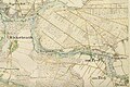
The Knippertzbach on the original map from 1846
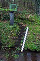
Knippertzbach at the level in Rickelrath


maintenance

The care and maintenance of the Knippertzbach is the responsibility of the Schwalmverband , which is based in Brüggen .
Tributary
- Gerkarther Graben from Gerkerath
- Hellbach from Leloh and from the JHQ Rheindahlen with a length of 1.9 kilometers
literature
- Hans Vogt: Lower Rhine water mill guide . 2nd Edition. Niederrhein Association, Krefeld 1998, ISBN 3-00-002906-0 , p. 436 .
- Horst Jungbluth and Helmuth Elsner: The Schwalm - In the valley of the mills . Mill stories of the Schwalm and its tributaries. 2nd Edition. 1990, p. 80-83 .
- Robert Mittelstädt: Detailed hydrological evidence according to BWK M3 / M7 for waters of the lowlands and sand areas using the example of the Knippertzbach (Schwalm catchment area) . Ed .: Hydrotec Ingenieurgesellschaft für Wasser und Umwelt mbH. March 5, 2009 ( bwk-nrw.de [PDF; 2.7 MB ]).
Web links
- Nature reserve "MG-002 Knippertzbachtal" in the specialist information system of the State Office for Nature, Environment and Consumer Protection in North Rhine-Westphalia
Individual evidence
- ↑ a b German basic map 1: 5000
- ↑ Topographical Information Management, Cologne District Government, Department GEObasis NRW ( Notes )
- ↑ Area directory for the water stationing map of the state of North Rhine-Westphalia ( Memento of the original from October 17, 2013 in the Internet Archive ) Info: The archive link was inserted automatically and has not yet been checked. Please check the original and archive link according to the instructions and then remove this notice. (PDF; 543 kB)
- ↑ Robert Mittelstädt: Detailed hydrological evidence according to BWK M3 / M7 for waters of the lowlands and sand areas using the example of the Knippertzbach (Schwalm catchment area) . Ed .: Hydrotec Ingenieurgesellschaft für Wasser und Umwelt mbH. March 5, 2009, p. 3 ( bwk-nrw.de [PDF; 2.7 MB ]). Detailed hydrological evidence according to BWK M3 / M7 for waters of the lowlands and sand areas using the example of the Knippertzbach (Schwalm catchment area) ( Memento of the original from October 11, 2010 in the Internet Archive ) Info: The archive link was automatically inserted and not yet checked. Please check the original and archive link according to the instructions and then remove this notice.
- ↑ Robert Mittelstädt: Detailed hydrological evidence according to BWK M3 / M7 for waters of the lowlands and sand areas using the example of the Knippertzbach (Schwalm catchment area) . Ed .: Hydrotec Ingenieurgesellschaft für Wasser und Umwelt mbH. March 5, 2009, p. 4 ( bwk-nrw.de [PDF; 2.7 MB ]). Detailed hydrological evidence according to BWK M3 / M7 for waters of the lowlands and sand areas using the example of the Knippertzbach (Schwalm catchment area) ( Memento of the original from October 11, 2010 in the Internet Archive ) Info: The archive link was automatically inserted and not yet checked. Please check the original and archive link according to the instructions and then remove this notice.
- ↑ Welcome to the Schwalm Association - a public corporation . Schwalmverband Brüggen. Retrieved February 9, 2013.