
Knippertzmühle
| Knippertzmühle
|
||
|---|---|---|
 Knippertzmühle in 1914 |
||
| Location and history | ||
|
||
| Coordinates | 51 ° 9 '58 " N , 6 ° 18' 14" E | |
| Location |
|
|
| Waters | Schwalm | |
| Built | 12th Century | |
| Shut down | 1920 because of dilapidation | |
| technology | ||
| use | OIL and GRAIN mill | |
| Grinder | 1 grind 1 oil press | |
| drive | Watermill | |
| water wheel | undershot | |

The Knippertzmühle was a water mill with an undershot water wheel .
geography
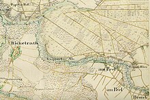
The Knippertzmühle was located between Rickelrath and Peel on the southern edge of the NATO headquarters near Eichhof on Eichhofstrasse. In front of the mill was a pond , which today serves as a rainwater retention basin . Today the water level is 68 m above sea level. NN . The mill was located in the so-called triangle , because this is where the former Kempen district , the Heinsberg district and the city of Mönchengladbach come together. The administrative district of Düsseldorf borders on the former administrative district of Aachen . Part of the mill was in the area of the city of Wegberg.
Waters
The Knippertzmühle was on the Knippertzbach , which begins in Rheindahlen on Broicher Straße and flows into the Schwalm near the Papelter Mühle . The Knippertzbach has a length of 6705 meters. The beginning of the stream is 70 m above sea level. NN , the confluence with the Schwalm near Schwaam at 57 m above sea level. NN . About one kilometer before it flows into the Schwalm, the Knippertzbach takes on the Hellbach , which is used for surface drainage from the Leloh area and JHQ headquarters. The care and maintenance of the water is the responsibility of the Schwalm Association , which is based in Brüggen .
history
The Knippertzmühle is one of the very few mills in the Schwalmtal that have left nothing behind except a small pond. As early as 1920 it was bought by the public sector and demolished because it was dilapidated.
Bach , Mühle and Müller have had the same name since at least the beginning of the 19th century, which indicates a long relationship. It was an oil and grinding mill with an undershot mill wheel with a pond. In the Ferrari map “Cruchten” from 1771, the mill is named with Knippers Meulen. As early as 1223 there was a dispute between the Cologne cathedral chapter and Otto I. von Hochstaden - Wickrath , about woad justice and this mill. No further information is available about the mill, but it is known that it had an undershot water wheel and was registered as a grinding mill in official investigations in 1830. The miller Johann Heinrich Knippertz was the last to run the mill until the beginning of the 20th century. Around 1920 the now closed mill was sold to the city of Rheindahlen. Since the masonry was soaked through , the building was demolished in 1922 because it was in disrepair.

Knippertzmühle around 1760
Prussian first recording in 1844

Mill pond of the Knippertzmühle

Mill pond as a rain retention basin


literature
- Hans Vogt: Lower Rhine water mill guide . Ed .: Verein Niederrhein eV Krefeld 1998, ISBN 3-00-002906-0 , 335, Knippertzmühle, p. 436-437 .
- Horst Jungbluth, Helmuth Elstner: The Schwalm - valley of the mills . Mill stories of the Schwalm and its tributaries. 2nd Edition. Ecken GmbH, Schwalmtal 1990.
Web links
- Stadtmarketing Wegberg (Ed.): Discover Wegberg in the valley of the 24 mills . 2013 ( wegbergermuehlen-leudalmolens.eu [PDF; 2.0 MB ; accessed on February 13, 2016]).
- Mill tour
Individual evidence
- ↑ Welcome to the Schwalm Association - a public corporation . Schwalmverband Brüggen. Retrieved February 16, 2013.
- ↑ Hans Vogt: Lower Rhine water mill guide . Ed .: Verein Niederrhein eV Krefeld 1998, ISBN 3-00-002906-0 , 335 Knippertzmühle, p. 436-437 .
- ↑ Horst Jungbluth, Helmuth Elstner: The Schwalm - valley of the mills . Mill stories of the Schwalm and its tributaries. 2nd Edition. Ecken GmbH, Schwalmtal 1990, p. 81 .
At the worm :
Beeretz mill |
Bommers Mill |
Frelenberger Mill |
Horriger Mill |
Hünshovener oil mill |
Grinder and Oil Mill Trips |
Marienthaler Mill |
Müllendorfer mill |
Lohmühle |
Lohmühle |
Eichenthal Mill |
Mill Hommerschen |
Oil and paper mill Oberbruch |
Porselener Mill |
Randerather oil mill |
Rimburg mills |
Süggerather mill |
Interrupt mill |
Full mill interruption |
Zweibrügger Mühle
An der Junge Wurm:
Aldenhover Mühle |
Brünkers Mill |
Dahlmühle |
Horster mill |
Karker Mill |
Kemper Mill |
Lambertz Mill |
Liecker mill |
Powder mill ] |
Schafhausen grain mill |
Schafhausen oil mill |
Town mill |
Valley mill |
Wolfhager Mühle
Am Rodebach :
Brommler Mühle |
Dahlmühle |
Angel Mill |
Etzenrather mill |
Ingentaler Mill |
Isenbruch Mill |
Istrater mill |
Tüddern grain mill |
Millener mills |
Mohrenmühle |
Square mill |
Vollmühle Tüddern |
Wehrer Mühle
An der Schwalm :
Bischofsmühle |
Post mill |
Kornmühle Tüschenbroich |
Kringsmühle |
Lohmühle |
Neumühle |
Oil mill Tüschenbroich |
Rossmühle |
Wegberger Mühle
Am Mühlenbach :
Buschmühle |
Holtmühle |
Meismühle |
Molz mill |
Schrofmühle
Am Helpensteiner Bach:
Dalheimer Mühle |
Helpensteiner Mill |
Rödgener Mühle
Am Beeckbach :
Ophover Mühle
Am Kitschbach :
Kitscher Mühle
Am Knippertzbach :
Knippertzmühle
Am Uebach :
Übacher Mühle