
Papelter mill
| Papelter mill
|
||
|---|---|---|
 Prussian original map from 1844 (Dorpowski) |
||
| Location and history | ||
|
||
| Coordinates | 51 ° 10 '41 " N , 6 ° 16' 47" E | |
| Location |
Germany
|
|
| Waters | Schwalm | |
| Built | 16th Century | |
| Shut down | 1928 after a fire | |
| technology | ||
| use | Oil and grain mill | |
| Grinder | 1 grind 1 oil press | |
| drive | Watermill | |
| water wheel | undershot | |

The Papelter mill in the municipality of Schwalmtal was a water mill with an undershot water wheel .
geography
The Papelter Mühle was located on the middle course of the Schwalm in the Lüttelforster area in the municipality of Schwalmtal in the district of Viersen . Above the Papelter mill was the Neumühle , below the Jennekes mill . Today the water level is 56 m above sea level.
history
The history of the Papelter mill goes back to the 16th century. The mill belonged to the " Knights of Papeler". This knight family had a coat of arms that consisted of a sloping bar and a star above it. At the beginning of the 17th century, the "von Papeler" family owned the mill and the homonymous farm that stood up on the street. The Lüttelforster merchant Johann Arnold Mühlenweg bought the Papelter Hof in 1752 for 2100 Reichstaler , and in 1754 the Papelter Mühle for 4000 Reichstaler. He died in 1775 and from then on the mill and the farm, sometimes together, sometimes separately, often changed owners and tenants. A document from 1756 provides information that the court and mill were a so-called Klüppellehen, i.e. loaned items, the receipt of which required knightly military service and loyalty to the liege lord.
The miller Derichs was the last operator of the mill. On October 28, 1928, the oil and grain mill burned down and work was finally stopped. The house has since been rebuilt as a residential building after another fire in the mid-1970s.
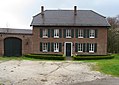
Papelter Hof estate

Back of the Papelter Hof
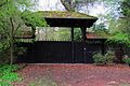
Papelter Mühle entrance area
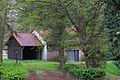
Farm building of the Papelter mill


literature
- Hans Vogt: Lower Rhine water mill guide. Krefeld 1998, page 437.
- Horst Jungbluth, Helmuth Elsner: The Schwalm - valley of the mills. Schwalmtal 1989, pages 41-43.
Web links
Individual evidence
At the Schwalm :
Borner Mühle |
Brempter mill |
Brüggener Mill |
Dilborn Mill |
Frankenmühle |
Jennekes Mill |
Lüttelforster Mühle |
Mühlrath mill |
Breakdown mill |
Papelter mill |
Radermühle |
Vennmühle
An der Niers :
Clörather Mühle |
Gibber mill |
Holtzmühle |
Langendonker Mill |
Mülhausen mill |
Neersdommer Mill |
Oedter Mill |
Schlossmühle Neersen
An der Nette :
Flootsmühle |
Henkenmühle |
Kothmühle |
Leuther Mill |
Lüthemühle |
Mill House Baerlo |
Nelsenmühle |
Neumühle |
Tüschenmühle |
Weuthenmühle
Am Hammer Bach :
Bongartzmühle |
Hammer mill |
Hüstermühle |
Plinzenmühle |
Schnockesmühle |
Sgoedenmühle
Am Dorfer Bach :
Biestenmühle |
Goetersmühle |
Kaisermühle |
Kimmelmühle |
Schricksmühle
Am Kranenbach :
Hausermühle |
Hüttermühle |
Pletschmühle |
Schierer Mühle
Am Mühlenbach :
Weiher Mühle |
Specker Mühle
Am Pletschbach :
Pletschmühle
Am Rintger Bach :
Klostermühle