
Oedter mill
| Oedter mill
|
||
|---|---|---|
 The wheel house of the Oedter Mühle |
||
| Location and history | ||
|
||
| Coordinates | 51 ° 19 '23 " N , 6 ° 22' 44" E | |
| Location | Germany | |
| Waters | Niers | |
| Built | Documented mention in 1273 | |
| Shut down | 1960 cessation of milling operations | |
| technology | ||
| use | Oil and grain mill | |
| Grinder | 1 grind 1 oil press | |
| drive | Watermill | |
| water wheel | 2 pieces undershot | |

The Oedter Mühle was a water mill on the Niers in Grefrath - Oedt (1623) with two undershot water wheels .
geography
The Oedter Mühle was located on the Niers in Mühlengasse 5 in the Oedt district in the North Rhine-Westphalian municipality of Grefrath in the Viersen district . The area on which the mill building is located is approximately 35 m above sea level.
The Niers supplied the Oedter mill with water for centuries. The care and maintenance of the water is the responsibility of the water and soil association of the Middle Niers, which is based in Grefrath .
history
The Oedter Mühle is mentioned for the first time in a document from 1273 and is the property of the St. Vitus Abbey in Gladbach. Uda Castle was built near the mill and was in the hands of the Archbishop of Cologne in 1313 , initially as a fiefdom , and in 1348 unrestrictedly together with the rule . The Archbishop took over in 1454 the Oedter and Mülhausener mill in long lease. The Oedter Mühle was a grinding and oil mill under one roof and shows two water wheels on a drawing from 1623. During the Thirty Years War (1643) the castle was blown up. It is not known to what extent the mill was damaged. In 1843 the mill belongs to the Holtz brothers from Süchteln . It ran - most recently electrically - until 1960. Today the mill building from the 19th century is an apartment building .
gallery
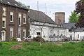
Residential and wheel house with tower of Uda Castle
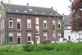
House of the Oedter Mühle
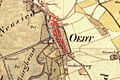
Tranchot map 1806


literature
- Hans Vogt: Lower Rhine water mill guide. 2nd Edition. Verein Niederrhein eV, Krefeld 1998, ISBN 3-00-002906-0 , pp. 525-526.
Web links
Individual evidence
At the Schwalm :
Borner Mühle |
Brempter mill |
Brüggener Mill |
Dilborn Mill |
Frankenmühle |
Jennekes Mill |
Lüttelforster Mühle |
Mühlrath mill |
Breakdown mill |
Papelter mill |
Radermühle |
Vennmühle
An der Niers :
Clörather Mühle |
Gibber mill |
Holtzmühle |
Langendonker Mill |
Mülhausen mill |
Neersdommer Mill |
Oedter Mill |
Schlossmühle Neersen
An der Nette :
Flootsmühle |
Henkenmühle |
Kothmühle |
Leuther Mill |
Lüthemühle |
Mill House Baerlo |
Nelsenmühle |
Neumühle |
Tüschenmühle |
Weuthenmühle
Am Hammer Bach :
Bongartzmühle |
Hammer mill |
Hüstermühle |
Plinzenmühle |
Schnockesmühle |
Sgoedenmühle
Am Dorfer Bach :
Biestenmühle |
Goetersmühle |
Kaisermühle |
Kimmelmühle |
Schricksmühle
Am Kranenbach :
Hausermühle |
Hüttermühle |
Pletschmühle |
Schierer Mühle
Am Mühlenbach :
Weiher Mühle |
Specker Mühle
Am Pletschbach :
Pletschmühle
Am Rintger Bach :
Klostermühle