
Clörath Mill
| Clörath Mill
|
||
|---|---|---|
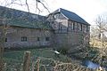
.jpg) The Clörather mill Clörather way seen from |
||
| Location and history | ||
|
||
| Coordinates | 51 ° 16 '44 " N , 6 ° 24' 57" E | |
| Location | Germany | |
| Waters | Niers | |
| Built | First mentioned in 1230 | |
| Shut down | 1930 after the Niers relocation | |
| Status | good condition | |
| technology | ||
| use | Grain mill | |
| Grinder | 1 grind | |
| drive | Watermill | |
| water wheel | undershot | |
| Website | Website of the Clörather Mühle | |

The Clörather Mühle is a former watermill located on the Niers in Clörath , a rural town on the outskirts of the North Rhine-Westphalian district town of Viersen .
geography
The Clörather Mühle is located (formerly on the Niers), Clörather Mühle 36, in the district of Clörath in the town of Viersen in the district of Viersen. The area on which the buildings stand is approx. 35 m above sea level.
The Niers in its old river bed supplied the Clörath mills with water for centuries until regulation in the 1930s. The care and maintenance of the water is the responsibility of the water and soil association of the Middle Niers, which is based in Grefrath .
history
The mill belonged to the Clörath House , an Electoral Cologne border fortification on the Niers that was first mentioned in 1230 . The Niers formed at this point, the boundary between electoral Koln (at the right Niersufer) and the as enclave for Duchy funds belonging Viersen (on the left Niersufer).
Only about 500 meters west also bordered (then on the left Niersufer) which at the time for the Clörather mill Duchy of Jülich belonging Süchteln from the north to the money Generic exclave Viersen, so that there would be a kind of triangle came. Around this point, a boundary stone was erected in the 18th century , again with the intention of marking the border between Kurköln and the Duchy of Jülich.
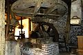
The fact that the Niers changed its course several times over the centuries makes the clarity in this border area even more difficult. The watermill was first mentioned in 1386 and was in operation until the 1930s when the Niers was straightened and moved west. Since then the mill has been without water. While the Clörath house was destroyed in the turmoil of the French occupation around 1794, the mill and the farmyard have been preserved. The buildings date from between 1650 and 1837. Inside the water mill, large parts of the grinder have been preserved.
gallery
The mill building

Economic sector

Living area south-west side

Residential buildings in the courtyard
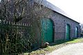
Economic sector
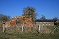
Ruins of Clörath Castle

The grain mill

The royal wheel of the mill
The mill gear

Millstone without housing

Wheel housing with existing wheel axle

Tranchot map 1806


Monument entry
The open, four-winged courtyard of the Clörath Mill is the still existing farm building of the old fortified house of Clörath in the Electorate of Cologne, which was already mentioned in a document in 1230 (cf. among others Peter Vander, Clörath House in the 1973 home book of the Kempen district. Krefeld), which was probably destroyed in the turmoil of the French Revolution in 1794 and is now still in ruins as a wall in the meadows behind the courtyard.
The current system consists of the single-storey brick- facing wing with wooden walls and split pins, the gable of which was used to access the courtyard. Immediately afterwards is the original mill, a two-story half - timbered house with a half- hipped roof . The whole complex was surrounded on all sides by the Niers until 1929, which in addition to the grain mill drove a second mill, namely an oil mill, which no longer exists.
The mill has not been in operation since the Niers was moved and straightened. At a right angle to the mill, the single-storey, rough plastered associated residential building connects. The former stable building to the southwest was converted for residential purposes. The brick-facing barn in the southeast was built around 1830. Its masonry was partially replaced after the Second World War . The age and historicity of the Clörath Mill are of great importance for the local history. In addition, it must be regarded as a typical example of the topographical settlement organisms that once shaped the Viersen area and is therefore essential for the history of the settlement. In addition to conveying the visual perceptibility of earlier work and production conditions, the well-preserved grinder offers technical and scientific information.
Preservation and use of the Clörather Mühle are therefore in the public interest in accordance with Section 2 (1) of the Law for the Protection and Care of Monuments in the State of North Rhine-Westphalia for scientific reasons, in particular for reasons of settlement history and settlement topography, local history and architectural history.
Viersen Monument List No. 70, entry: October 9, 1985
literature
- Hans Vogt: Lower Rhine water mill guide. 2nd Edition. Niederrhein Association, Krefeld 1998, ISBN 3-00-002906-0 , pp. 518-521.
- Peter Vander: House Clörath. Heimatbuch des Kreis Kempen-Krefeld 1973. pp. 240–253.
- Ludwig Mertens: House Clörath and the Clörath mill. Festschrift 2012 pp. 180–186.
Web links
Individual evidence
- ↑ http://www.mittlereniers.de/
- ↑ The borderline between the Electorate of Cologne and the Duchy of Jülich in Clörath in the 18th century ( memento of the original from July 17th, 2009 in the Internet Archive ) Info: The archive link was automatically inserted and not yet checked. Please check the original and archive link according to the instructions and then remove this notice.
At the Schwalm :
Borner Mühle |
Brempter mill |
Brüggener Mill |
Dilborn Mill |
Frankenmühle |
Jennekes Mill |
Lüttelforster Mühle |
Mühlrath mill |
Breakdown mill |
Papelter mill |
Radermühle |
Vennmühle
An der Niers :
Clörather Mühle |
Gibber mill |
Holtzmühle |
Langendonker Mill |
Mülhausen mill |
Neersdommer Mill |
Oedter Mill |
Schlossmühle Neersen
An der Nette :
Flootsmühle |
Henkenmühle |
Kothmühle |
Leuther Mill |
Lüthemühle |
Mill House Baerlo |
Nelsenmühle |
Neumühle |
Tüschenmühle |
Weuthenmühle
Am Hammer Bach :
Bongartzmühle |
Hammer mill |
Hüstermühle |
Plinzenmühle |
Schnockesmühle |
Sgoedenmühle
Am Dorfer Bach :
Biestenmühle |
Goetersmühle |
Kaisermühle |
Kimmelmühle |
Schricksmühle
Am Kranenbach :
Hausermühle |
Hüttermühle |
Pletschmühle |
Schierer Mühle
Am Mühlenbach :
Weiher Mühle |
Specker Mühle
Am Pletschbach :
Pletschmühle
Am Rintger Bach :
Klostermühle