
Gibbermill
| Gibbermill
|
||
|---|---|---|
-small.jpg) The Gibbermühle c. 1727 in a picture by the painter Roidkin . |
||
| Location and history | ||
|
||
| Coordinates | 51 ° 15 '46 " N , 6 ° 26' 48" E | |
| Location | Germany | |
| Waters | Niers | |
| Built | 1386 first mention | |
| Shut down | 1928 Destroyed by fire | |
| technology | ||
| use | Grain mill | |
| Grinder | 1 grind | |
| drive | Watermill | |
| water wheel | undershot | |

The Gibbermühle was a water mill on the former river bed of the Niers near Neersen (today: City of Willich ) with an undershot water wheel .
geography
The Gibbermühle was located on the Niers in the area of the hamlet “am Bökel / Hagwinkel”, which is now part of the Willich district of Neersen. The town of Willich is part of the Lower Rhine district of Viersen in the west of the German state of North Rhine-Westphalia . The area on which the mill building once stood is about 36 m above sea level .
The Niers in its old river bed supplied the Gibbermühle with water for centuries. The care and maintenance of the water is the responsibility of the water and soil association of the Middle Niers, which is based in Grefrath .
history
The Gibbermühle was first mentioned in a document in 1386. The mill belonged to the Vogt von Neersen . From 1502 the lords of Virmond were the owners . The mill also bore the name Gibbelmühle or Giebertmühle. The mill was of great importance in its environment. In the 17th / 18th In the 19th century, three carts were constantly on the move to collect the grist in Willich, Anrath and Vorst with the permission of the elector . In 1805 Johann Theodor Beckers bought the secularized Gibbermühle. The mill was operated as a grain mill until 1928. Then it burned down completely and was not rebuilt.
literature
- Hans Vogt: Lower Rhine water mill guide. 2nd Edition. Association Niederrhein, Krefeld 1998, ISBN 3-00-002906-0 , pp. 508-509.
Web links
gallery
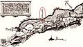
The Gibbermühle on an old map of the Oedt office from around 1660.

The Gibbermühle on an old French map from around 1805.
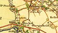
The Gibbermühle on an old Prussian map from around 1844.
(Bottom left in the map image)
The former location of the Gibbermühle in 2012: woodshed in the private garden.
.jpg)

.jpg)
.jpg)
Individual evidence
At the Schwalm :
Borner Mühle |
Brempter mill |
Brüggener Mill |
Dilborn Mill |
Frankenmühle |
Jennekes Mill |
Lüttelforster Mühle |
Mühlrath mill |
Breakdown mill |
Papelter mill |
Radermühle |
Vennmühle
An der Niers :
Clörather Mühle |
Gibber mill |
Holtzmühle |
Langendonker Mill |
Mülhausen mill |
Neersdommer Mill |
Oedter Mill |
Schlossmühle Neersen
An der Nette :
Flootsmühle |
Henkenmühle |
Kothmühle |
Leuther Mill |
Lüthemühle |
Mill House Baerlo |
Nelsenmühle |
Neumühle |
Tüschenmühle |
Weuthenmühle
Am Hammer Bach :
Bongartzmühle |
Hammer mill |
Hüstermühle |
Plinzenmühle |
Schnockesmühle |
Sgoedenmühle
Am Dorfer Bach :
Biestenmühle |
Goetersmühle |
Kaisermühle |
Kimmelmühle |
Schricksmühle
Am Kranenbach :
Hausermühle |
Hüttermühle |
Pletschmühle |
Schierer Mühle
Am Mühlenbach :
Weiher Mühle |
Specker Mühle
Am Pletschbach :
Pletschmühle
Am Rintger Bach :
Klostermühle