
Uebacher mill
| Uebacher mill
|
||
|---|---|---|
 Memory of the Übacher mill |
||
| Location and history | ||
|
||
| Coordinates | 50 ° 55 '10 " N , 6 ° 7' 8" E | |
| Location | Germany | |
| Waters | Uebach | |
| Built | 12th Century | |
| Shut down | around 1875 | |
| technology | ||
| use | Grinding mill | |
| Grinder | 1 grind | |
| drive | Watermill | |
| water wheel | overshot | |

The Übacher Mühle was a water mill with an overshot water wheel on the Uebach in the city of Übach-Palenberg in the North Rhine-Westphalian district of Heinsberg in the administrative district of Cologne .
geography
The Übacher mill had its location on Uebach today 's marketplace in the city Übach-Palenberg. The area on which the mill once stood is approx. 102 m above sea level . In front of the mill was a 250 × 80 m large mill pond , which was also used by the farmers for flax rotting .
Waters
The Uebach, which was also called Mühlenbach and Palenbach , is around 9 km long and is the shortest tributary of the Wurm . The original sources were in the area between Merkstein and Alsdorf . Today the Uebach has become a regulated flood ditch for sewage and surface water , some of which is piped in the settlement area. In the Middle Ages the Uebach drove two mills. One of these mills was at the Mühlenbach house on the market square. The water association Eifel - Rur (WVER) is responsible for the care and maintenance of the water.
history
A small fountain system with a water wheel and an information board with historical data reminds of the location of the Übacher mill, which was popularly known as Et Mölke . Local historiography dates the mill to the 12th century. The single- speed mill worked as a grain mill and was driven by an overshot water wheel. The silting up of the mill pond led to the closure of the mill in 1875.
gallery
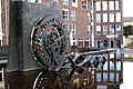
Et Mölke on the market square in Übach-Palenberg

Information board for the Übacher mill
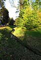
Stream course of the Uebach

Übach on the first recording from 1846

Übach on the new recording from 1892

Übach on the tranchot card 1805/1807


literature
- Hans Vogt: Lower Rhine water mill guide 2nd edition. Verein Niederrhein, Krefeld 1998, ISBN 3-00-002906-0 , pages 282-283.
- Peter Jansen: In search of the old origins of the Übach and its tributaries , home calendar Selfkantkreis Geilenkirchen-Heinsberg 1962, page 63 ff.
Web links
Individual evidence
- ^ German basic map 1: 5000
- ↑ Topographical Information Management, Cologne District Government, Department GEObasis NRW ( Notes )
- ↑ http://www.wver.de/
At the worm :
Beeretz mill |
Bommers Mill |
Frelenberger Mill |
Horriger Mill |
Hünshovener oil mill |
Grinder and Oil Mill Trips |
Marienthaler Mill |
Müllendorfer mill |
Lohmühle |
Lohmühle |
Eichenthal Mill |
Mill Hommerschen |
Oil and paper mill Oberbruch |
Porselener Mill |
Randerather oil mill |
Rimburg mills |
Süggerather mill |
Interrupt mill |
Full mill interruption |
Zweibrügger Mühle
An der Junge Wurm:
Aldenhover Mühle |
Brünkers Mill |
Dahlmühle |
Horster mill |
Karker Mill |
Kemper Mill |
Lambertz Mill |
Liecker mill |
Powder mill ] |
Schafhausen grain mill |
Schafhausen oil mill |
Town mill |
Valley mill |
Wolfhager Mühle
Am Rodebach :
Brommler Mühle |
Dahlmühle |
Angel Mill |
Etzenrather mill |
Ingentaler Mill |
Isenbruch Mill |
Istrater mill |
Tüddern grain mill |
Millener mills |
Mohrenmühle |
Square mill |
Vollmühle Tüddern |
Wehrer Mühle
An der Schwalm :
Bischofsmühle |
Post mill |
Kornmühle Tüschenbroich |
Kringsmühle |
Lohmühle |
Neumühle |
Oil mill Tüschenbroich |
Rossmühle |
Wegberger Mühle
Am Mühlenbach :
Buschmühle |
Holtmühle |
Meismühle |
Molz mill |
Schrofmühle
Am Helpensteiner Bach:
Dalheimer Mühle |
Helpensteiner Mill |
Rödgener Mühle
Am Beeckbach :
Ophover Mühle
Am Kitschbach :
Kitscher Mühle
Am Knippertzbach :
Knippertzmühle
Am Uebach :
Übacher Mühle