
Lucherberg
|
Lucherberg
Inden municipality
Coordinates: 50 ° 50 ′ 37 ″ N , 6 ° 22 ′ 23 ″ E
|
|
|---|---|
| Height : | 132 m |
| Area : | 3.09 km² |
| Residents : | 1073 (June 30, 2008) |
| Population density : | 347 inhabitants / km² |
| Incorporation : | January 1, 1972 |
| Postal code : | 52459 |
| Area code : | 02423 |

Lucherberg is a place in North Rhine-Westphalia and a district of Inden in the Düren district . Together with Lamersdorf and Frenz , Lucherberg forms the corners of a triangle, in the middle of which is the resettlement site Inden / Altdorf , the new center of the municipality of Inden.
geography
On the south-eastern outskirts of the village lies the Lucherberger See , on the northwestern outskirts of the village the artificial dump Goltsteinkuppe . As a symbol for the Indeland , a huge steel frame structure, called " Indemann ", has been erected there. Between Lucherberg and Lamersdorf the southwest running Wehebach flows into the Inde . The Waagmühle is located at the southern exit of the village.
history
In 1533 a chapel in Lucherberg is mentioned for the first time, which together with today's parish of St. Peter in Merken (today in Düren ) is part of the parish of “St. Mary Immaculate Conception ”in Pier (today in Inden). It was demolished in 1857 and replaced by a new building, which was badly damaged on November 16, 1944 during a major air raid on the Düren / Jülich region. The inauguration of the new church and its high altar took place on August 11, 1951. Lucherberg lies on the edge of the "Inden II" opencast mine .
When the diocese of Aachen was established in 1804, Lucherberg appeared as a parish in the canton of Düren , while the neighboring towns of Lamersdorf and Frenz belonged to the canton of Eschweiler . In 1815 Lucherberg and the Lucherberg office, to which Luchem (today to Langerwehe) belonged until 1972, came to the Düren district formed by Prussia . From 1825 to 1972, the Lucherberg parish belonged to the former Derichsweiler deanery (now part of Düren).
In 1819 lignite was found on the manor of Baron von Goltstein in Lucherberg, and from 1826 to 1869 lignite was mined in the Goltstein mine . The Goltsteinkuppe is a reminder of this to this day .
On January 1, 1972 Lucherberg was incorporated into Inden.
traffic
The next junction is Langerwehe on the A 4 , which was opened in 2015. The nearest train station is Langerwehe on the Cologne-Düren-Aachen line . Several bus lines connect Lucherberg with Frenz, Lamersdorf, Inden / Altdorf, Schophoven, Merken , Luchem and Langerwehe.
photos
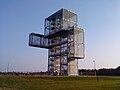
The Indemann on the Goltsteinkuppe

Lucherberg from the Indemann


Individual evidence
- ^ Federal Statistical Office (ed.): Historical municipality directory for the Federal Republic of Germany. Name, border and key number changes in municipalities, counties and administrative districts from May 27, 1970 to December 31, 1982 . W. Kohlhammer, Stuttgart / Mainz 1983, ISBN 3-17-003263-1 , p. 306 .
_COA.svg)
Existing districts:
Frenz |
Inden / Altdorf |
Lamersdorf |
Lucherberg |
Schophoven (with the hamlet Viehöven )
Former districts:
Inden |
Altdorf |
Geuenich |
Pier (with Pommenich and Vilvenich )