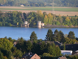
Lucherberger See
| Lucherberger See | ||
|---|---|---|

|
||
| Geographical location | Inden , Düren district , North Rhine-Westphalia | |
| Location close to the shore | Düren , Eschweiler | |
| Data | ||
| Coordinates | 50 ° 50 '27 " N , 6 ° 22' 51" E | |
|
|
||
| surface | 64 ha | |
| volume | 8.6 million m 3 | |
| Maximum depth | up to 14 m | |
The Lucherberger See is located near Lucherberg in the municipality of Inden in the district of Düren .
The former "Lucherberg 3" open- cast lignite mine is located directly on the federal motorway 4 between Düren and Eschweiler . It has a depth of approx. 14 m and an area of approx. 56 ha.
Lucherberger See is owned by RWE Power , which operates the nearby Weisweiler power station and the waste incineration plant there . The lake is fed with the water of the Rur and serves as a cooling water or process water reservoir.
Club sailing and surfing are used on the lake. The lake is widely known as a fishing water.
In the course of the Inden opencast mine, the Lucherberger See will in future be located near the opencast mine area and should be drained from 2020. However, this has not yet been formally approved.
See also

Web links
Individual evidence
- ↑ Lucherberger See will perish from 2020 in the Aachener Zeitung on April 4, 2017, accessed on November 17, 2018
