Distelrath
|
Distelrath
City of Düren
Coordinates: 50 ° 49 ′ 0 ″ N , 6 ° 31 ′ 20 ″ E
|
|
|---|---|
| Postal code : | 52351 |
| Area code : | 02421 |
|
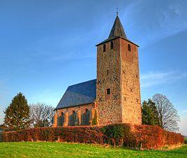
The Ühledömche, seen from the northwest, in March 2009
|
|
Distelrath is a former suburb and today's district of Düren in North Rhine-Westphalia .
location
Distelrath is located on the eastern outskirts of Düren in the direction of Merzenich and has grown firmly into the city over the centuries. The old trade route from Düren to Cologne , today's B 264 , leads directly through Distelrath .
history
Excavations have brought to light a Roman villa . Further finds suggest a Carolingian settlement in the 9th century. Distelrath was first mentioned in 1152 as a collection of farms and a chapel. The destruction of the Thirty Years' War did not leave the village unscathed, but it did leave the Distelrath chapel , the Ühledömche . In 1831 a major fire destroyed the entire village. Here, too, the chapel remained undamaged.
Barrel body
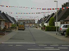
Tonnedbod is the vernacular name for Tonnedorf . This is how the Kerpener Strasse settlement on the eastern outskirts of Düren is popularly named. The name Tonnendorf wants to remind us of the old herring barrels that used to stand under the downpipes to collect water. The settlement built the Reichsheimstättenwerk in 1933 with 24 houses for large families as part of the suburban small settlements project .
Transport links
The Distelrath station was hub of the Dürener circular path on the following routes:
- Düren – Distelrath railway line
- Distelrath – Embken railway line
- Distelrath – Schneidhausen railway line
Nowadays Distelrath can only be reached via the bridge road junction of the Düren – Euskirchen railway line .
Others
- The transport company Dürener Kreisbahn GmbH , which was founded in 1908, has had its headquarters in Distelrath at the station of the same name since it was founded (formerly for trams , today for buses ) . Also there have Rurtalbahn GmbH and the Rurtalbus GmbH their company headquarters.
- In 1915, south of Distelrath, between the railway line to Euskirchen and the old brickworks (now a satellite town), an airship airport with two anchorages and many ancillary buildings was built. He received a small train connection through the Düren district orbit. The airship LZ 77 was stationed here. The Düren airship hangar was dismantled in January / February 1918 and reused as a hangar for the Gotha bombers on the island of Norderney .
Individual evidence
- ↑ Tonnendorf on the outskirts is 75 years old. In: Aachener Zeitung from August 26, 2008


