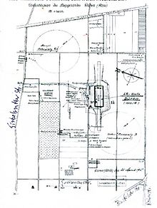
Airship hangar Düren
The airship hangar Düren belonged to the airship deployment port of Düren - Distelrath in what is now North Rhine-Westphalia .
history
During the First World War one often heard and saw the "Air Cruisers of His Majesty the Emperor" in the sky over the Eifel during practice and front trips. During the war there were numerous airship stations (see airship hall ). From here one started on missions to France and Great Britain .
location
The airship deployment port (LS-E port) Düren was completed on December 14, 1914.
The Düren civil engineer Gerhard Schaaf had worked out the construction plan, according to which the complex was built about 600 m from the railway line Düren - Euskirchen and 400 m from the former brickworks (today the location of the housing estate " Satellite City " or "Satellite District"). The hall was built by the Berlin company Deutsche Luftschiffhallenbau-Gesellschaft - System Ermus .
The airship hangar was 28 m × 180 m and about 30 m high. There was space for a zeppelin in the hall . For the LZ 107 (LZ = airship zeppelin), the last army zeppelin, Düren was the regular place. The air cruiser was 179 m long and held 35,980 m³ of hydrogen gas . A Maybach engine with 240 hp was housed in each of the four gondolas . At times LZ 33 was also housed here.
The airship port included not only the hall, but also many ancillary buildings, such as the barracks for the crews, bomb, ammunition, oil and gasoline stores. Two anchorages, each with a 180 m radius, were also set up. A narrow-gauge railway was specially built for transport between the hall and the warehouse . A siding was laid to the nearby Distelrath train station .
Whereabouts
In January / February 1918 the hall was dismantled and rebuilt in a heavily modified form on the North Sea island of Norderney as an aircraft hangar for Gotha bombers.
In 1984 most of the remains of the hall foundations were removed from the ground. The archaeologists of the Rhineland Regional Association carried out excavations in September 2014, followed by a presentation of the results.
Web links
- War brings airship port to Düren. In: Aachener Zeitung from August 22, 2014
- Entry on the airship hall in Düren-Distelrath in the database " KuLaDig " of the Rhineland Regional Association
Individual evidence
- ↑ http://www1.wdr.de/mediathek/video/sendung/lokalzeit/lokalzeit-aus-aachen/videodiezeppelinbasisindueren100_size-L.html?autostart=true#banner
Coordinates: 50 ° 48 ′ 13.3 " N , 6 ° 30 ′ 38.1" E


