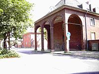
Green belt (Düren)
The green belt in Düren , North Rhine-Westphalia , is a settlement project from the beginning of the 20th century. The green belt road is also located in the settlement area .
As early as 1892 there was an urban development plan drawn up by the Cologne city architect Josef Stübben in Düren . Here it was determined that Düren urgently needed new settlement areas in order to master the poor housing situation in the course of industrialization .
The then town planner Heinrich Dauer planned the green belt settlement between the Cologne-Aachen railway line, today's Schoellerstraße and Kölnstraße. The first residential buildings were built in 1914 on Brückenstraße, Fröbelstraße and on Freiheitsplatz. From 1925 onwards, Dauer's plans were implemented more quickly and generously.
While in the first construction phase before the First World War mainly single-family houses were built, multi-storey apartment blocks were built after the war. These houses on Werderstrasse, Freiheitsstrasse, Goebenstrasse and Meiringplatz show architectural features of Expressionism . Its planning was carried out by Max Ernst Schneiders, who had studied under Hans Poelzig as a master student at the Academy of Arts (Berlin) in 1921 and 1922 .
The street Blücherstrasse, which was built after 1930, corresponds to the architectural conception of functionalism .
There are different house forms in the settlement, but all buildings were made of red brick . Only a single building material was used, which was manufactured in a brick factory in the settlement area .
When the inner city of Düren was bombed on November 16, 1944 (see air raids on Düren ), the green belt was largely spared and, apart from a few necessary modernization work, has retained its charm as an independent settlement to this day.
The building area got the name green belt because a green belt with trees and gardens runs through the district.
The popular name for the green belt is Little Chicago . This name came about after the Second World War and is due to the solidarity and family comfort. Other opinions attribute the name to the high level of petty crime in this district at the time. The song from Klein Chicago Ländchen , which was created at that time and gives a little insight into the difficult conditions of the post-war period, was recorded on a CD by the dialect group Zollhuus .
See also
Web links
Coordinates: 50 ° 48 ′ 43.1 ″ N , 6 ° 29 ′ 43.5 ″ E


