Golden line


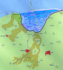
The Golden Line was created in the 17th century as the border between the Principality of East Friesland and the County of Oldenburg in Harle Bay on the Frisian North Sea coast . On the mainland it forms the dividing line between the two districts of Wittmund and Friesland .
Emergence
The Harle Bay has been gradually diked since the 16th century . In order to avoid disputes over ownership and the drainage of the newly won land, Princess Christine Charlotte of East Friesland and Count Anton Günther von Oldenburg signed a border treaty on December 22, 1666.
The starting point was the East Frisian-Jeverland border post on the dike built in 1658 (the so-called pile dike ) between Neufunnixsiel and Neugarmssiel. Starting from there, Johann von Honart , a sworn engineer from the Netherlands and who was commissioned by the East Frisian side, and the Jever engineer Falk , drew a line on a nautical chart for the Oldenburg side up to a point exactly between two beacons, the for this purpose were set on the edge of the high dunes in the east of Spiekeroog and in the west of Wangerooge . The engineers allegedly marked the limit on the map in gold ink. That is why it still bears the name Golden Line on maps and street signs today .
Despite the treaty of 1666, the border dispute between the two neighboring countries continued for some time. The East Frisians insisted on a further eastern course of the border. A final agreement was only reached in 1743 after Oldenburg paid 11,000 thalers to Prince Carl Edzard of East Friesland. Since then, the Golden Line has been the border between Jeverland in Oldenburg and East Frisia, which was Prussian and later Hanoverian since 1744, as part of the province of Hanover .
Regardless of the shift of the two North Sea islands to the east, the original route remained valid. So the golden line finally ran over the island of Spiekeroog.
Nowadays, however, the municipal boundary of Spiekeroogs follows the shoreline, and the surrounding mudflats and tidal creeks are non-community area . The border between the land and the national park area on the island lies far west of the golden line.
Maintenance of tradition
The historical development gave various causes for disputes between the neighbors.
The Guild for the Golden Line of 1666 has set itself the task of remembering the historical differences between the former territories and promoting communication between the two districts of Friesland and Wittmund .
Web links
- Description at Museumsweg Carolinensiel
- Drawing of the golden line, 1667 on Kulturerbe.niedersachsen.de