Kongeå
|
Kongeå Königsau |
||
|
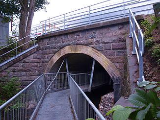
Bridge over the Königsau in Vamdrup |
||
| Data | ||
| location | Syddanmark region , Denmark | |
| River system | Kongeå | |
| source | south of Vamdrup ( Kolding municipality ) 55 ° 24 ′ 58 ″ N , 9 ° 18 ′ 53 ″ E |
|
| muzzle | north of Ribe in the North Sea Coordinates: 55 ° 22 ′ 48 ″ N , 8 ° 38 ′ 36 ″ E 55 ° 22 ′ 48 ″ N , 8 ° 38 ′ 36 ″ E
|
|
The Kongeå [ ˈkɔŋəoːʔ ] (German: Königsau ) is a 65 km long flowing water in Jutland . It runs north of Ribe ( German Ripen ) on the west coast and divides the country until shortly before Kolding . For centuries, its middle and upper reaches defined the border between the Danish regions of Sønderjylland (≈ Southern Jutland ) and Nørrejylland (≈ Northern Jutland ) and, from the 13th century, between the Duchy of Schleswig as a fiefdom of Denmark and the actual Kingdom of Denmark .
That did not apply to the lower reaches. The area around Ribe south of Königsau was always part of the Danish home country. After the German-Danish War , Königsau - with the exceptions mentioned - formed a natural border between Prussia and the Kingdom of Denmark from 1867 and the German-Danish border after 1871. Since the referendum in Schleswig in 1920, North Schleswig has been Danish again. The Königsau now formed the northern administrative border of the district Sønderjyllands Amt . This was dissolved with the municipal reform in 2007 and incorporated into the Syddanmark region .
The Königsau continues to form the natural border between Sønderjylland / Süderjutland in the south and Sydjylland / Südjutland (→ the southern part of Nørrejylland) in the north - somewhat confusing for the inexperienced .
