Amphidromy
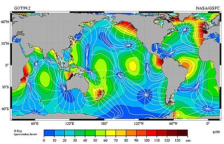
As amphidromic point (also Amphidrom from Greek. Ἀμφίδρομος ἀmphίdromos "circumferentially") refers to the profile of a tidal wave in a marine basin, in which the phase star-shaped lines run around a location. There is no tidal range at this amphidromic point . The tidal waves travel clockwise or counterclockwise around the amphidromic points.
Physical relationships
Physically, these are Kelvin waves . The great north-south expansion of the land masses of the Old World and America prevents the tidal waves from moving evenly around the entire globe. Instead, the gravitational pulls of the sun and moon maintain one or more standing waves in each ocean basin . The Coriolis force sets these standing waves in rotation, counterclockwise in the deep ocean in the northern hemisphere and clockwise in the southern hemisphere.
The extent of an amphidromy depends on the speed at which the rotating shaft is moving. This wave speed C is proportional to the square root of the water depth t .
Within an amphidromy, the height of the tidal wave ( tidal range ) increases with the distance from its center. This explains why the ebb and flow of the tides are more pronounced on the east coast of England than in Cuxhaven .
North Sea shallow sea
The North Sea has because of their small depth an unusually high density amphidromischer systems, three side by side on a small surface. Their centers are located in the southern part between the English peninsula East Anglia and Holland , in the middle above the Jutlandbank between northern England and the Danish Jutland , and in the north off the coast of Norway near Stavanger .
Deep seas
In the deep oceans of the world, the tidal waves rotate at several hundred kilometers per hour. Since wave crests and troughs there often extend over a thousand kilometers and have correspondingly gentle slopes, the level at individual coastal locations in a deep ocean does not rise and fall faster than at the shallow North Sea. Horizontal water movements are not faster either.
Map displays
The two pictures show the amphidromic systems of the world's oceans and the North Sea . The phase lines emanating from the amphidromic points in a star shape connect points with the same tide level. This means that high water (and thus also low water ) occur at approximately the same time in the connected locations . In the world map, the curved black arrows illustrate the direction of rotation. The length and position of these arrows describe a period of six hours and thus about half of a tidal period. The surface colors represent the amplitude of the tidal wave.
literature
- Frank Ahnert: Introduction to Geomorphology. 4th edition. Ulmer UTB, 2009, ISBN 978-3-8252-8103-8 . 329, Fig. 25.2., After C. A. M. King: Beaches and Coasts. 2nd Edition. St. Martins Press, London 1972.
- E. Brown, A. Colling, D. Park, J. Phillips, D. Rothery, J. Wright: Waves, Tides and Shallow-Water Processes . The Open University, Walton Hall, Milton Keynes, England 2006, ISBN 0-7506-4281-5 .
- HV Thurman, AP Trujillo: Introductory Oceanography . Pearson Prentice Hall, Upper Saddle River, New Jersey 2004, ISBN 0-13-143888-3 .

