Skallingen
| Skallingen | ||
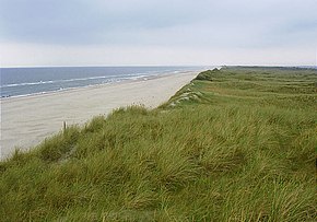
 Skallingen, beach, view to the north |
||
| Geographical location | ||
|
|
||
| Coordinates | 55 ° 31 '3 " N , 8 ° 14' 46" E | |
| Waters 1 | North Sea | |
| Waters 2 | Ho Bugt | |
| length | 7 km | |
| width | 3 km | |
| surface | 20 km² | |
Skallingen is a peninsula on the Danish North Sea coast between the headland Blåvands Huk and the island of Fanø . It is part of the Danish Wadden Sea National Park , which was established in 2010.
The spit hook was not created until the 17th century after the Burchardi flood of 1634. Around 1910 it was about 9 km long, currently it is about 7 km long and 3 km wide. The approximately 2,000 hectare uninhabited area is supervised as a state property by the nature authority Naturstyrelsen .
The long, flat sandy beach is a popular destination, there are only a few holiday homes behind the dunes. In the summer months, cows and sheep graze on the marsh .
The closest settlement is Ho . From here between July 15th and September 15th at low tide you can go on mudflat hikes in the Ho Bugt , across to the bird island Langli . The Ho Bay forms the northern end of the Wadden Sea of the North Sea .
German minefields from the Second World War were laid out on Skallingen until 2012 . In 2005, some sections of the beach were therefore closed to the public. The Danish state had the mines cleared for around 100 million kroner (approx. 13 million euros).
Web links
- Skallingen National Park Vadehavet. Official website (Danish)
