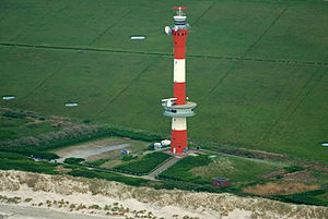
New lighthouse Wangerooge
| New lighthouse Wangerooge | ||
|---|---|---|
| The lighthouse photographed from the north from the air. | ||
| Place: | Wangerooge | |
| Location: | Western part of the island | |
| Geographical location: | 53 ° 47 '24.3 " N , 7 ° 51' 25.9" E | |
| Height of tower base: | 1.6 m above sea level NN | |
| Fire carrier height : | 67.2 m | |
| Fire height : | 61.2 m (sea fire) 25.8 m (guide and warning lights) |
|
|
|
||
| Identifier : | Fl.R.5s (sea fire) F.WRG. ( Pilot light ) F.WR. (Warning fire) |
|
| Operating mode: | Xenon gas discharge lamps | |
| Function: | Sea, guide and warning lights | |
| Construction time: | 1966-1969 | |
| Operating time: | since November 7, 1969 | |
The New Wangerooge Lighthouse is a combined lighthouse and radar tower on the island of Wangerooge . It is used by shipping as a sea, guide and warning light when navigating the Outer Jade and Outer Weser as well as traffic safety in this area.
history
For the expansion of the fairway to the Wilhelmshaven harbors , it became necessary in the 1960s to replace the old lighthouse from 1856 with a new building whose beacon could show a control sector free from the foothills of the Wangerooger Plate sandbank .
In the autumn of 1966, construction of the tower began on the northwest coast of the island. After the completion of the shell in September 1967, the then very sophisticated technical expansion of the plant began. Two years later, on November 7, 1969, the beacon went into operation.
Structure and equipment
The 67.2 m high reinforced concrete tower stands on 24 foundation piles and an underground basement . When projection is approximately 25 m height, the so-called operating level with the control and warning fire. The original facade of red and white ceramic tiles was replaced by an aluminum cladding in 1982 .
The fully automatic beacon is maintained and monitored by the Wilhelmshaven Waterways and Shipping Office . It is connected to the public power grid and can be supplied by its own diesel generator in an emergency . The equipment of the building includes:
- The sea fire, an all-round fire for orientation in the southern German Bight .
- The pilot light, a sector light for the control of the outer jade.
- The warning light, a sector light for the name of Groyne H in the Harle-Seegatt .
- In 1979 the tower received a radar system on the operating floor. The image is transmitted to the traffic control center in Wilhelmshaven via a radio link . The facility forms the Jade radar chain with the Minsener Oog, Hooksielplate and Tossens radar towers.
- A VHF radio direction finder antenna has been installed on the top of the tower since 1982.
- In the first few years, a marine radio fire was operated on the station .
Philatelic
With the Initial Issue 7 June 2018 which gave German Post AG in the series Lighthouses a postage stamp in the nominal value of 70 euro cents out with the motif of the lighthouse. The design comes from the graphic designer Johannes Graf from Dortmund .
Web links
- WSA Weser-Jade-Nordsee - Homepage - Wangerooge. WSA Wilhelmshaven , accessed on February 15, 2020 .
- Erik Kohl: The New Lighthouse. Retrieved April 26, 2015 .

