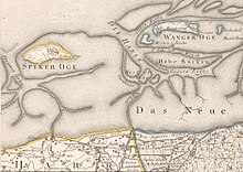
Harle (Seegatt)
The Harle or the Harle-Seegatt is a maritime gate in the North Sea .
It runs in a north-south direction between the East Frisian islands of Spiekeroog and Wangerooge and, so to speak, forms the outer continuation of the Harle river , which flows into the sea at Carolinensiel and leads to the Harle lake as Carolinensieler Balje .
The main channel of the sea channels Harle divides south of the imaginary connecting line between the two islands in addition to the main fahrwasser serving Caroliniensieler Balje in the two channels Old Harle ( Muschelbalje ) and Dove Harle on, the latter serves as access to the port of Wangerooge at the Southwest end . The position and depth of the fairways are subject to strong changes due to the currents (especially due to the tide ); this is often reflected in changes to the navigation mark (re-buoying) by the competent waterways and shipping authority Wilhelmshaven (WSA).
For a long time, Wangerooge was the island with the greatest migration from west to east. The reason for this was the harle sea , which constantly gnawed the western tip of the island. Only since the 1960s to protect breakwaters and a revetment made of concrete, the west end of Wangerooge before loss of land. The longest groyne (“Buhne H”) has been jutting out from the western tip of Wangerooges to almost the eastern end of Spiekeroog since 1940 and represents an obstacle for shipping that should not be underestimated, as it can not be driven over even during floods .
With the expansion of the Wangeroog port area, Niedersachsen Ports is now responsible for the transition area between the port and Seegatt. The new fairway was named Wangerooge approach .
See also
Web links
- Information about the Harle at www.wattenschipper.de
- Illustration with drawn Harle, Dove Harle and Alte Harle on page 15 of the linked document (PDF file; 3.93 MB)
Individual evidence
- ↑ Access Harlesiel / Carolinensiel at www.segeln-forum.de , accessed on July 22, 2011
- ↑ Description of the Harle (PDF, 117 kB)
- ↑ N-Ports and the Waterways and Shipping Office agree on limits ( memento of the original from August 12, 2014 in the Internet Archive ) Info: The archive link was automatically inserted and not yet checked. Please check the original and archive link according to the instructions and then remove this notice. , accessed July 22, 2011
Coordinates: 53 ° 46 ′ 11 " N , 7 ° 50 ′ 58" E
