
Schillig
|
Schillig
Wangerland municipality
Coordinates: 53 ° 42 ′ 6 ″ N , 8 ° 1 ′ 24 ″ E
|
||
|---|---|---|
| Height : | 2 (2–5) m above sea level NN | |
| Residents : | 116 (December 31, 2010) | |
| Postal code : | 26434 | |
| Area code : | 04426 | |
Location of Schillig in Lower Saxony |
||
 Aerial photo of Schillig (2012)
|
||

Schillig is a seaside resort in the municipality of Wangerland in the Lower Saxony district of Friesland . It is part of the Horumersiel- Schillig district and is located on the extreme northeast tip of the East Frisian Peninsula , but in the Oldenburg part.
geography

The place is about 20 kilometers north of Wilhelmshaven , two kilometers north of Horumersiel and four kilometers east of Minsen . Upstream are the islands of Wangerooge , Mellum and Minsener Oog .
Nature reserves
To the northwest of Schillig is the Wiesenbatterie Schillig nature reserve , which has been under nature protection since August 7, 1982. The nature reserve is a former defensive structure that was built before the First World War and was largely blown up in 1945. As a wooded area in the otherwise largely treeless marsh, the area is of particular importance for the bird world.
history

In the vicinity of Schillig, the first 23 meter high lighthouse was built in 1876/1877 , which was later replaced by a striking yellow model. He stood at the later strategically important entrance into the Jade to Wilhelmshaven. Therefore Schillig was already at the time of the Imperial Navy military outpost of the west bank of the Jade Bay lying Wilhelmshaven, a major German Reich naval port .
Parts of the navy were stationed at Schillig Roads during the Franco-German War of 1870/71 ( Napoleon Hill ) and the First and Second World Wars . On the night of October 29th to 30th, 1918, the mutiny began on some of the ships of the imperial fleet lying there in the roadstead, which a few days later would lead to the Kiel sailors' uprising , the November revolution and the proclamation of the republic in Germany . In the time of military use there was even a railway line from Jever to Schillig, which was operated exclusively by the navy . In order to protect the Jade Fairway, which runs directly past Schillig, several coastal forts of the naval artillery were built east of the village at the end of the 19th and beginning of the 20th century . Between Schillig and Minsen, these were the Schillig meadow battery and the dike battery . Both forts were about 100 to 500 meters in size and had moats and casemates .
Another cannon position was the watt battery , which stood on a dike-like elevation on which there is now a restaurant next to the campsite. In addition, there was an Imperial Navy message center in Schillig , which handled the optical signal traffic with the warships lying in front of Schillig-Reede.
After the First World War, the two military facilities had to be demilitarized , but were reactivated as part of the German rearmament from 1935. During the Second World War, the naval artillery positions and the extensive military installations on the offshore island of Wangerooge belonged to the coastal protection . The long-range cannons were only used in Schillig in the last days of the Second World War, when they fired inland to fight the enemy. Furthermore, anti-aircraft guns were housed in the positions , which belonged to a ring of anti-aircraft systems around Wilhelmshaven. In contrast to Wangerooge, the bunker and cannon positions on the mainland were neither attacked from the sea nor from the air, but were also blown up after the war.
Name development

The name is derived from the term Schill (like shell, word related to the English shell) for mussels . The extensive occurrences deposited ocean currents and surf here. They used to be mined for the production of lime . A white shell sculpture in the central square at the entrance to the village indicates the special importance of shells.
Storm surges
Due to its exposed location in the north-eastern corner of the East Frisian peninsula, Schillig was always particularly at risk from storm surges . Since the 15th century, several dikes and lands were lost in the direction of Horumersiel , which were later regained. The Christmas flood of 1717 tore a creek 82 meters wide and seven meters deep in the sea dike between Schillig and Horumersiel , which is now included in the spa facilities.
religion

The majority of the residents of Schillig are Evangelical Lutheran . The St. Nikolai Church, built in 1977, belongs to the Minsen parish .
On February 4, 2012, the new Roman Catholic St. Mary's Church was consecrated in Schillig . It replaces the previous church from 1967, which in the meantime was dilapidated and was demolished. The new church serves the around 800 Catholics in the community of Wangerland and the tourist pastoral care in the holiday resort.
Economy and Infrastructure
tourism
Bathing began as early as 1856 after a storm surge destroyed the holiday resort on Wangerooge. At that time, bathers found accommodation with the beacon keeper and the surrounding houses. In 1939 there were already around 750 holiday guests. From the 1950s, the facilities for vacation and leisure were expanded. In 1954 the campsite was built and is now one of the largest in Europe. In addition to individual old farmhouses, there are now mainly holiday apartments and houses as well as apartments. In summer, mudflat hikes take place regularly to the uninhabited island of Minsener Oog .
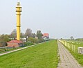
The 42 meter high, former lighthouse

Map of the former military and railway facilities

Typical grass and sand beach, in the background the port facilities of Wilhelmshaven

Wreck of a ship that ran aground off Schillig in 1962


traffic
Between 1935 and 1939, special trains ran on vacation services on the naval railway ; this line was dismantled in 1949.
Schillig is currently connected to Wilhelmshaven and Jever by two Weser-Ems Bus routes. In the summer and autumn holidays, there is also a tourist bus that runs to Jever via various sections of the other two lines. However, many trips, especially during school holidays, only run by prior arrangement . Schillig is in the tariff area of the Ems-Jade transport association .
See also
Web links
- Website Horumersiel-Schillig
- Schillig in the Lower Saxony Historical Atlas
- Schillig lighthouse (Oberfeuer)
- Schillig lighthouse (Unterfeuer)
Individual evidence
- ^ City of Wilhelmshaven - residents in the area around Wilhelmshaven (PDF; 406 kB), accessed on January 31, 2013.
- ↑ minsen.de ( Memento of the original from July 15, 2013 in the Internet Archive ) Info: The archive link was inserted automatically and has not yet been checked. Please check the original and archive link according to the instructions and then remove this notice.
- ↑ House of God with sea view

Altgarmssiel | Forrien | Friederikensiel | Hohenkirchen | Hooksiel | Horum | Horumersiel | Middoge | Minsen | Neugarmssiel | Oldorf | Schillig | Tettens | Waddewarden | Wiarden | Wiefels