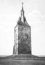
West Tower (Wangerooge)

The west tower is a 56 meter high tower of clinker on the Lower Saxony North Sea island of Wangerooge . It was built in 1932 and is now used by the German Youth Hostel Association as a youth hostel . The name of the tower, which had two previous buildings in the course of the island's history, is based on its location at the western end of the island. The west tower is now a listed building .
history
First west tower
The first west tower, probably built in the 14th century, was the church tower of Nikolai Church in the island village. The island church was dedicated to Saint Nicholas as the patron saint of seafarers. It was located about five kilometers west of today's western edge of the island and served ships as a landmark for orientation. As the sea drew closer as a result of the east drift of Wangerooge, the village with its church and cemetery had to be abandoned. Around 1590, the Nikolaiturm collapsed as a result of the effects of water. Its 15 meter high ruin served as a navigation mark for a long time .
Second west tower
The second west tower was built between 1597 and 1602. With the construction of the tower, the wish of Bremen merchants for a landmark for their ships entering the Weser was met. This made them subject to customs duties , and customs duties were for a long time the most important state revenue of the Grand Duchy of Oldenburg . In the pointed roof of the tower was a lantern room with 48 windows, in which the beacon was initially operated with the help of vegetable oil. Later it burned as a coal fire on a nearby bloom . During the day, the three-pointed roof of the west tower continued to provide orientation for the ships. The 50-meter-high multi-purpose building had five floors and served as a church , refuge from storm surges, prison, ice cellar and storage room for flotsam . The church interior was on the first floor and could accommodate 130 people.
Due to the east drift of the island, the sea moved from the west to the tower over time. With the New Year flood of 1855 , a severe storm surge tore the island in three parts. The flood wreaked havoc on the old island village around the then west tower, with only the tower, completed in 1602, standing still.
When cracks appeared in the masonry of the west tower during a storm surge in 1860, the entire furnishings of the tower church were moved to the old bailiwick . There it was lost two years later in another storm surge. Around 1900 the already damaged tower stood far in the water and was blown up at the end of 1914 ostensibly for military reasons. Wangerooge had been converted into a fortress from 1912 to protect the entrance to the Outer Jade to the Imperial War Port Wilhelmshaven . At the beginning of the First World War , when a sea attack by the British fleet was expected, the tower was not intended as a distinctive navigation mark to make orientation easier for the enemy. According to an unofficial version, the reason was put forward by the Navy to get rid of the structure, which it was previously responsible for costly maintenance. The round foundation was later incorporated into a groyne . It can still be seen and inspected today at low tide near the New Lighthouse in the west of the island.
Third and current west tower
A few years after the demolition in 1914, the idea of building a tower for the youth came up. In 1932, today's west tower was built as the third west tower in the history of Wangerooge, several hundred meters southeast of the previous tower that was blown up in 1914. It was created as a replica of the previous building through the voluntary work of the Oldenburger Turnerbund . The new tower is a massive brick building in exposed masonry with a square floor plan of 12 × 12 meters. The building has eight floors and a steep tent roof that ends in three points. The middle point is designed as a raised observation tower in copper. A 15-meter-deep foundation of sheet piling and concrete walls connects the tower with the stable geest subsurface of the island. From the completion of the tower at Pentecost in 1933, the tower was used as a hostel for the Hitler Youth , who had taken over the youth hostel association when they were brought into line in 1933. In the new tower from 1932, a coat of arms of the Oldenburg family on the wall reminds of the previous building from 1602. After the Second World War, the tower became a youth hostel of the DJH . In 2005 a spacious new youth hostel was built next to the tower.
See also
literature
- Ernst Andreas Friedrich : The west tower of Wangerooge , pp. 186–188, in: If stones could talk. Volume I, Landbuch-Verlag, Hannover 1989, ISBN 3-7842-0397-3 .
Web links
Individual evidence
- ↑ Heie Focken Erchinger, Martin Stromann: Storm surges - coastal and island protection between Ems and Jade. Norden 2004, p. 163.
- ^ Wangerooge - An Illustrated Travel Guide. Edition Temmen, Bremen 2003, p. 81.
- ↑ Nils Aschenbeck: Wangerooge, an island tells history. Oldenburg 2002, p. 18.
- ^ Hajo Bernett : The reconstruction of the west tower of Wangerooge in the mirror of contemporary history. In: Wolfgang Buss , Arnd Krüger (Hrsg.): Sports history: maintaining tradition and changing values. Festschrift for Wilhelm Henze . NISH, Duderstadt 1985, ISBN 3-923453-03-5 , pp. 161-174.
Coordinates: 53 ° 47 '4.9 " N , 7 ° 51' 27.3" E


