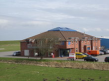
Harle Airfield
| Harle Airfield | |
|---|---|

|
|
| Characteristics | |
| ICAO code | EDXP |
| Coordinates | |
| Height above MSL | 2 m (7 ft ) |
| Transport links | |
| Distance from the city center | 0.7 km east of Harlesiel |
| Basic data | |
| opening | 1972 |
| operator | Frisian Airfield Harle -Brunzema and Partner KG |
| Terminals | 1 |
| Employees | approx. 20 |
| Start-and runway | |
| 09/27 | 510 m × 20 m asphalt |
The airfield Harle is a special airfield in the community Wangerland in the district of Friesland in Lower Saxony , about 700 meters from Harlesiel removed. However, the airfield has an address of the city of Wittmund , as its only access is possible from Harlesiel, which belongs to the Wittmund district of Carolinensiel .
Flight operations
The airfield is approved for aircraft up to 2000 kg and the type Britten Norman BN-2 "Islander" . AVGAS 100-LL and corresponding types of oil are available at the aircraft filling station . There is an undercover hangar with an aircraft hangar and a restaurant nearby.
All year round there are half-hourly flights to and from Wangerooge airport . The regular flights to Wangerooge, to the other East Frisian islands , to Helgoland as well as charter flights are operated by the company FLN Frisia-Luftverkehr .
Harle Airport may only be approached by resident companies. Other aviation participants require prior registration and permission from the responsible aviation authority ( PPR by telephone).
