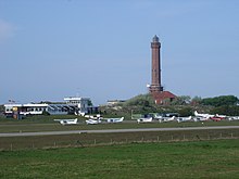
Norderney Airfield
| Norderney Airfield | |
|---|---|

|
|
| Characteristics | |
| ICAO code | EDWY |
| IATA code | NRD |
| Coordinates | |
| Height above MSL | 2 m (7 ft ) |
| Transport links | |
| Distance from the city center | 4.5 km east of Norderney |
| Street | At the lighthouse |
| train | no connection |
| Basic data | |
| opening | 1970 |
| operator | Norderney Airport GmbH |
| surface | around 30 ha |
| Terminals | 1 |
| Start-and runway | |
| 08/26 | 1000 m × 20 m asphalt |
The airfield Norderney is the airfield of Lower Saxony island Norderney .
Motor gliders, powered aircraft up to 5700 kg, ultralight aircraft and helicopters up to 10,000 kg can be operated on the airfield.
history
Norderney Airfield was opened in 1970. As early as 1914 there were plans to build a civil airfield. The airfield that existed until then was destroyed by the Allies in 1945. Therefore, in 1954, a makeshift airfield was put into operation on a meadow on the Wadden Sea in front of the golf hotel, but it had to be closed due to recurring flooding and was replaced by today's airfield.
In 1957 the air sports club was founded, which still uses the airfield for aviation.
literature
- Jann Saathoff: Norderney . tape 1 - The structural development of the island of North Sea Island. Soltau-Kurier-Norden, Norden 2010, ISBN 978-3-939870-82-1 .
Web links
Commons : Flugplatz Norderney - Collection of images, videos and audio files
- Website of Flughafen Norderney GmbH
- 75 years of Norderney Airport. (PDF; 8.12 MB) Flughafen Norderney GmbH, accessed on September 8, 2012 .
Individual evidence
- ↑ Norderney Airfield - History. (No longer available online.) Flughafen Norderney GmbH, archived from the original on May 13, 2007 ; Retrieved May 11, 2011 .
