
Gröde
| coat of arms | Germany map | |
|---|---|---|

|
Coordinates: 54 ° 38 ' N , 8 ° 43' E |
|
| Basic data | ||
| State : | Schleswig-Holstein | |
| Circle : | North Friesland | |
| Office : | Pellworm | |
| Height : | 4 m above sea level NHN | |
| Area : | 2.52 km 2 | |
| Residents: | 10 (Dec 31, 2019) | |
| Population density : | 4 inhabitants per km 2 | |
| Postal code : | 25869 | |
| Area code : | 04674 | |
| License plate : | NF | |
| Community key : | 01 0 54 039 | |
| LOCODE : | DE GXR | |
| Address of the municipal administration: |
Uthlandestrasse 1 25849 Pellworm |
|
| Website : | ||
| Mayor : | Jürgen Kolk | |
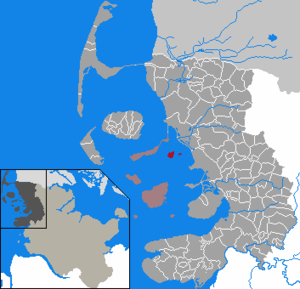
| Location of the community Gröde in the district of North Friesland | ||
  |
||

The Hallig Gröde ( Danish Grøde , North Frisian di Grööe ; also: Gröde-Appelland , Low German Grööd ) is one of the ten Halligen in North Friesland in the Schleswig-Holstein Wadden Sea National Park . It consists of the no longer inhabited former Hallig Appelland (Danish Abelland , North Frisian Åpellöön or Aapellöön ) in the north and the inhabited Hallig Gröde in the south, which were connected to each other around 1900 during coastal protection measures .
The municipality of Gröde is the smallest independent municipality in Germany with ten inhabitants (as of September 30, 2019), according to other information nine inhabitants . Hallig Habel , which is not permanently inhabited, also belongs to the 2.52 km² community .


geography
Gröde is a Hallig in the North Frisian Wadden Sea . The stone edge that almost completely surrounds them protects the island from loss of land during storm surges .
The Hallig is flooded an average of twenty to thirty times during the year at Landunter (with the exception of the two terps ). The two terps are settlement areas for the local population. There are four residential buildings on Knudtswarft. The Kirchwarft is a little smaller. The Hallig school, the church and a teacher's apartment are located here. At 4.3 m above sea level , it is the highest point on the Hallig. The school and teacher's apartment have been vacant since 2012.
Both terps are surrounded by ring dikes so that they can withstand storm surges. As with all Halligen, all residential buildings on the first floor have a shelter that stands on four concrete pillars that are about four meters into the terp. There is a fething between the buildings on Knudtswarft . The cemetery is located on the Kirchwarft next to the church and school building. The Neu-Peterswarft on the way to the pier, which was destroyed at the end of the 19th century, is now used as a storage facility for building materials.
 NASA satellite image of Gröde numbered with terps, Hallig Habel center , mainland top right |
||||
|
Living - space - no. 1 |
Terps | Topographic name |
Population update December 31, 2005 |
|
|---|---|---|---|---|
| population | households | |||
| Former Hallig Appelland (north) | ||||
| no terp 2 | ||||
| Former Hallig Gröde (south) | ||||
| 2 | Kirchwarft 3 | church | - | - |
| 3 | Knudtswarft | Group of houses | 13 | 6th |
1 residential space no. 1 is reserved for the uninhabited Hallig Habel , which also belongs to the municipality of Gröde and has only one terp with a bird protection station, which is only manned by a bird warden in summer.
2 According to an old map, there used to be the Appelländerwarft near the north-western tip of the Hallig.
3 Also called Schulwarft, as the church and school with the teacher's apartment are under one roof here.
history


In ancient times, Gröde, like its neighboring Halligen Appelland and Habel, belonged to the Uthlands populated in North Frisia . The Halligen were separated from the mainland by storm surges and subsequently suffered land losses due to further floods and ocean currents. In the Burchardi flood in 1634, a person drowned on the three Halligen. The St. Margarethen Church was built in 1779. It is probably the seventh church at this point. It contains an altar from 1592. Before the February flood of 1825 , there were 23 houses on the then three independent Halligen Gröde, Appelland and Habel, eight of which were destroyed. One of three terps on Gröde was also destroyed. In 1825 there were 90 inhabitants on Hallig Gröde. By 1874 this number halved. At the beginning of the 20th century, Gröde grew together with the Hallig Appelland located to the north, after a creek between the two Hallig islands was interrupted with a dam for reasons of coastal protection .
Belonging to the Danish Duchy of Schleswig until the German-Danish War in 1864 , Gröde subsequently became part of Prussia and Germany.
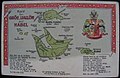
Old card on postcard, with the separate Halligen Gröe and Appellön

Map of the Halligen 1858, separated by Gröde and Appelland

Hallig Gröde around 1895
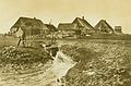
Knudtswarft (1895)

Knudtswarft seen from the Kirchwarft


politics

With fewer than 70 inhabitants, according to Section 54 of the Schleswig-Holstein municipal code, the municipality has no municipal council, but a municipal assembly in which all residents who are entitled to vote take part.
The municipality of Gröde is the smallest electoral district in Germany. The Gröder election results were regularly announced as the first fixed result shortly after the polling stations were closed. For the 2013 federal election , however, all residents opted for postal voting for the first time .
Economy and Infrastructure
The residents draw their income from renting out holiday homes and from farming as a sideline . The Halligland is managed in the form of a common commons . In addition, most of the residents are employed by the State Office for Coastal Protection, National Park and Marine Protection Schleswig-Holstein . Since 1976 Gröde has been supplied with electricity and water from the mainland. There is also a telecommunication line.
traffic
The Rungholt and the Seeadler operate from the mainland port Schlüttsiel to Gröde. There is no regular timetable. From the port of Strucklahnungshörn on Nordstrand the excursion boat Adler V occasionally runs , more rarely the Adler Express ; there is also a small marina . There is no car traffic on Gröde.
Flora and fauna
In summer, the Hallig of sea lavender blooms on the meadows . Gröde is a stopover for migratory birds on the way from southern England and south-western Europe to Siberia . For example, 10,000 to 15,000 brent geese rest on the Hallig every year.
literature
- Taken Hansen: A description of Hallig Gröde from 1814. Published by Jens Lorenzen. Nordfriisk Institut, Bredstedt / Bräist 1979, ISBN 3-88007-080-6 .
- Jens Lorenzen (Ed.): Three Hallig descriptions from around 1800. Hooge 1794, Nordmarsch 1807, Gröde 1814 (= Nordfriisk Instituut . No. 99 ). Nordfriisk Institut, Bredstedt / Bräist 1990, ISBN 3-88007-164-0 .
- Ulf Hahne: The Halligen Hooge and Gröde. An economic and socio-geographic study . Ed .: Institute for Regional Research and Information in the German Border Association e. V. Flensburg (= Flensburg regional studies . Volume 1 ). Research center for regional cultural studies at the Flensburg University of Education, Flensburg 1990, ISBN 3-923444-33-8 .
Web links
- Pellworm office near the city of Husum
- Private website about Gröde
- Old map of Gröde, Habel and Oland (on an old postcard)
Individual evidence
- ↑ North Statistics Office - Population of the municipalities in Schleswig-Holstein 4th quarter 2019 (XLSX file) (update based on the 2011 census) ( help on this ).
- ↑ Inhabitants 3rd quarter 2019 statistik-nord.de (Excel)
- ↑ groede.de , accessed on March 6, 2020
- ↑ Müller's Large German Local Book 2012. Complete local book. Walter de Gruyter, Berlin 2012, ISBN 978-3-11-027806-4 , p. 466 ( limited preview in the Google book search).
- ↑ Schleswig-Holstein topography. Vol. 3: Ellerbek - Groß Rönnau . 1st edition Flying-Kiwi-Verl. Junge, Flensburg 2003, ISBN 978-3-926055-73-6 , p. 310 ( dnb.de [accessed on April 26, 2020]).
- ↑ Old map of Gröde, Habel and Oland (on an old postcard): North Frisian Apellönerwerv
- ↑ [1]
- ↑ The federal election has already taken place on Gröde. In: Weser courier . September 17, 2013, accessed September 20, 2013.
- ^ Benjamin Lassiwe: Hallig Gröde - Germany's smallest community. Municipal, accessed November 2, 2019 .
- ↑ Hallig Gröde. In: adler-schiffe.de. Retrieved April 13, 2018.
Achtrup | Ahrenshöft | Ahrenviöl | Ahrenviölfeld | Alkersum | Almdorf | Arlewatt | Aventoft | Bargum | Behrendorf | Bohmstedt | Bondelum | Bordelum | Borgsum | Bosbull | Braderup | Bramstedtlund | Bredstedt | Breklum | Dagebüll | Drage | Drelsdorf | Dunsum | Elisabeth-Sophien-Koog | Ellhöft | Emmelsbüll-Horsbüll | Narrow Sands | Fresendelf | Friedrich-Wilhelm-Lübke-Koog | Friedrichstadt | Galmsbüll | Garding | Garding, parish | Goldebek | Goldelund | Gröde | Grothusenkoog | Haselund | Hattstedt | Hattstedtermarsch | Högel | Spar | Hooge | Hörnum (Sylt) | Horstedt | Hude | Humptrup | Husum | Immenstedt | Joldelund | Kampen (Sylt) | Karlum | Katharinenheerd | Klanxbüll | Klixbull | Koldenbüttel | Kolkerheide | Kotzenbüll | Ladelund | Langeneß | Langenhorn | Leak | Lexgaard | List on Sylt | Löwenstedt | Lütjenholm | Midlum | Mildstedt | Fog | Neukirchen | Nieblum | Niebüll | Norddorf on Amrum | Norderfriedrichskoog | North beach | Norstedt | Ockholm | Oevenum | Oldenswort | Oldersbek | Olderup | Oldsum | Ostenfeld (Husum) | Oster-Ohrstedt | Osterhever | Pellworm | Poppenbüll | Ramstedt | Rantrum | Reußenköge | Risum-Lindholm | Rodenäs | Sankt Peter-Ording | Schwabstedt | Schwesing | Seeth | Simonsberg | Sollwitt | Sönnebüll | Sprakebull | Stadum | Stedesand | Struckum | South end | Süderhöft | Süderlügum | South March | Sylt | Tating | Tetenbull | Tinningstedt | Tönning | Tümlauer-Koog | Uelvesbüll | Uphusum | Utersum | Viöl | Vollerwiek | Vollstedt | World | Wenningstedt-Braderup (Sylt) | Wester-Ohrstedt | Westerhever | Westre | Winnert | Wipe | Witsum | Wittbek | Wittdün on Amrum | Joke word | Wobbenbüll | Wrixum | Wyk on Föhr

Islands in Denmark and Germany:
Amrum |
Fanø |
Foehr |
Koresand |
Langli |
Mandø |
Norderoogsand |
Pellworm |
Rømø |
Sylt |
Uthorn
Halligen:
Gröde |
Habel |
Hamburger Hallig |
Hooge |
Langeneß |
Norderoog |
Nordstrandischmoor |
Oland |
Süderoog |
South fall
High sands:
Japsand |
Jordsand |
Boy name sand |
Kniepsand |
Cormorant Island |
Süderoogsand