Holtland
| coat of arms | Germany map | |
|---|---|---|

|
Coordinates: 53 ° 17 ' N , 7 ° 35' E |
|
| Basic data | ||
| State : | Lower Saxony | |
| County : | Empty | |
| Joint municipality : | Hesel | |
| Height : | 4 m above sea level NHN | |
| Area : | 14.71 km 2 | |
| Residents: | 2233 (Dec. 31, 2019) | |
| Population density : | 152 inhabitants per km 2 | |
| Postal code : | 26835 | |
| Area code : | 04950 | |
| License plate : | LER | |
| Community key : | 03 4 57 011 | |
| Association administration address: | Rathausstrasse 14 26835 Hesel |
|
| Mayor : | Karl-Heinz Groß ( SPD ) | |
| Location of the municipality of Holtland in the district of Leer | ||

Holtland is a municipality in the joint municipality of Hesel in the district of Leer in Lower Saxony . The municipality has 2233 inhabitants and covers an area of 14.66 square kilometers.
Community structure
In addition to the village of Holtland, the districts Holtland-Nücke and Siebestock belong to the municipality .
history
The village of Holtland emerged as a Geestdorf more than 1000 years ago . In a list of taxes, the land register of the Werden monastery, from the 9./10. In the 19th century, Holtland was still called Mundigast.
In 1891 a roll with 24 coins was found while removing a mound in the parish of Holtland. The front shows a Greek cross with four points, one in each corner of the cross, a wreath of pearls around the cross and the inscription X HLVDOVVICVS IMP, on the back a temple facade with a cross on top and the inscription XRISTIANA RELIGIO. According to the inscription, these are coins from the time of Louis the Pious, a son of Charlemagne, who lived between 814 and 840 AD. ruled. A human skeleton was found under the coins. Forty years earlier, several human skeletons were found on this mound. It was probably a burial mound.
The oldest surviving church in the Hesel community is in Holtland, the 750-year-old St. Mary's Church .
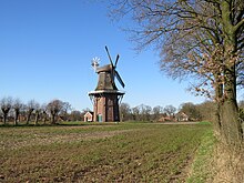
In the middle of the village is the Dutch windmill as a symbol of the community. It was completed in 1864 and replaced the old post mill from 1701.
In the Middle Ages, Holtland belonged to the Hooge Loogen in East Friesland.
politics
Municipal council
The council of the Holtland municipality consists of 13 councilors. This is the specified number for the member municipality of an integrated municipality with a population between 2001 and 3000 inhabitants. The 13 council members are elected for five years each by local elections. The current term of office began on November 1, 2016 and ends on October 31, 2021.
The last local election on September 11, 2016 resulted in the following:
| Political party | Proportional votes | Number of seats | Change voices | Change seats |
|---|---|---|---|---|
| SPD | 62.6% | 8th | −1.8% | −1 |
| CDU | 32.4% | 4th | + 12.6% | +1 |
| Otto Weber | 5.1% | 1 | + 5.1% | +1 |
The turnout in the 2016 local elections was 61.5%, above the Lower Saxony average of 55.5%. For comparison - in the previous municipal election on September 11, 2011, the turnout was 54.3%.
mayor
The mayors of the member municipalities of the joint municipality of Hesel are not elected directly, but by the council members in the constituent council meeting. Mayor is Karl-Heinz Groß from the SPD, Deputy Mayor Manfred Schlömp. Community director is Uwe Themann.
traffic
The federal highways 72 and 436 run through the municipality . There is a connection to the federal motorway 28 south of the municipality in Brinkum .
Personalities
- Andrea Bunjes (born February 5, 1976), hammer thrower, born in Holtland
Web links
Individual evidence
- ↑ State Office for Statistics Lower Saxony, LSN-Online regional database, Table 12411: Update of the population, as of December 31, 2019 ( help ).
- ↑ Freerk Steinböhmer: Timberlae in Timberlae-Timmel -Developments of a village, publisher village association "Ums Timmel eV, 2011
- ^ H. Thomsen: On the Holtlander coin finds. In: Yearbook of the Society for Fine Arts and Patriotic Antiquities in Emden . Vol. 9, 1890, pp. 101-103 ( online , accessed May 20, 2017).
- ↑ ostfriesland.de: Holtlander Mühle , accessed on May 20, 2017.
- ↑ Dettmar Coldewey: Frisia Orientalis - data on the history of the country between Ems and Jade. 5th edition. Lohse-Eissing, Wilhelmshaven 1987, ISBN 3-920602-13-7 .
- ^ Lower Saxony Municipal Constitutional Law (NKomVG) in the version of December 17, 2010; Section 46 - Number of MPs , accessed on December 28, 2016.
- ↑ a b extern.sghesel.de: Local council election Holtland 2016: final result (PDF; 394 kB), accessed on December 28, 2016.
- ↑ sghesel.de: Holtland municipal council election 2011: final result , accessed on December 28, 2016 (PDF).
- ↑ sg-hesel.de: Holtland municipal council , accessed on December 28, 2016.


