
Ostenholz


Ostenholz is a residential area in the Hartem district of the community-free area Osterheide in the Heidekreis district in the Lüneburg Heath ( Lower Saxony ). It was formerly a municipality in Ostheidmark in the old district of Fallingbostel . The area of the Ostenholz Moor and various individual farms also belonged to the community . a. the Heemenhof, Sieken, Sölterbruch and Söhnholz.


geography
The Hohe Bach and the Meierbach flow in the east and south of the municipality. Both flow into the Meiße southeast of Hodenhagen . Two old main routes used to run through the area: the " ole Heerweg ", a side branch of the old Bremen - Walsrode - Celle military road , and to the north of it the " Dürweg ", which led via Ettenbostel and Oerbke to Soltau . The latter was lined with Bronze Age barrows . One can conclude from this that it was probably an ancient military and trade route. In the south of Ostenholz lies the Ostenholzer Moor, which is used almost exclusively by the Bundeswehr as a military training area ( Ostenholzer Moor military training area ). The Bergen military training area borders directly to the north. About 1,400 meters northwest of Ostenholz, near Mengdorf, the Ostenholzer Mühle, a post windmill that was put into operation in 1732 , stood on a hill 82 m above sea level . It was the largest post mill in the region and was mainly used to grind grain . She could process 20 quintals of grain a day . In 1945 the mill was demolished. To the south of Ostenholz, in the Westenholzer Bruch, there is still the Hanshof today , which is known from the Hermann Löns novel from 1909 " The Last Hansbur ". There was a hunting lodge near this courtyard, which he often visited, sometimes for days, and which he also spent the night there. There was also the “Lönshütte”. The hut still exists, but was rebuilt on a different plot of land about 650 meters east of the courtyard.
From Ostenholz there is an access road through 5.4 kilometers of the restricted area of the military training area to the seven stone houses . Ammunition leftovers are regularly cleared for visitors . Public access is usually on weekends and public holidays from 8:00 a.m. to 6:00 p.m., provided that there is no military exercise.
History

The oldest, but undated, document on " Osterholt " can be found in the Lüneburg document book, in the archive of the Walsroder monastery St. Johannis , recorded by the landscape director of Hodenberg . The oldest dated message: In 1360, in document no. 152 of the Hodenberg document book, Duke Wilhelm II of Braunschweig-Lüneburg enfeoffs Heinrich von Hodenberg with a farm to Osterholte . In the Lüneburg feudal register from 1360, the name of the old Ostenholzer Markgenossenschaft “ up me dure ” (on the Dür) can be found for the first time , to which Oberhode and probably also a Hof von Westenholz belonged.
The people around Ostenholz suffered greatly in many wars. On the old military and trade routes attracted the marauding mercenaries in the Thirty Years' War (1618-1648) by the Dür. Foreign troops also got through here during the Seven Years' War (1756–1763). And also during the Napoleonic period (1792–1815), troops moved eastwards for days along the old military route.
As early as 1624, a file in the Hanover State Archives contained the first documentary mention of a school in Ostenholz. In 1711 the schoolmaster Brockmann, who at the same time pursued the wheel maker trade, taught 115 children. At that time there was no general compulsory education. The focus of the lessons was in winter, as the children were needed to work in the fields in summer. Due to the high number of now 200 to 250 school children - there were also children from Oberhode - a second school building was built in 1837. Due to dilapidation, it was replaced by a new building in 1861, which was used until 1939. As a result of the emigration to America from 1844 onwards, the reduction in the number of births and after Oberhode built its own school building, the number of pupils fell continuously and reached its lowest level in 1930 with 89 children.

Probably the oldest rural inn in the province of Hanover stood on the Wünnenhof in Ostenholz . It is already mentioned in the Celle treasury from 1438. Hermann Löns was staying in this inn when the news of the mobilization for the First World War arrived.
In the course of the establishment of the Bergen military training area , the resettlement of the population and the clearing of the part of the municipality that was needed for the training area took place from summer 1935 to May 1936. The farm owners were compensated, the buildings on the practice area were mostly demolished (see Destruction of the Ostheidmark in the time of National Socialism ).
The total size of the municipality of Ostenholz was 2956 hectares , of which 1896 hectares fell into the military training area. Of the 610 residents living in Ostenholz at the time of resettlement, 565 had to evacuate their farms and accommodations.
Population development
Ostenholz had the following population development:
1770 - 235 inhabitants
1821 - 320 inhabitants
1933 - 556 inhabitants
religion

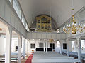
The Evangelical Lutheran Church of the “St. John the Baptist” parish in Düshorn-Ostenholz is a parish church for the villages of Ostenholz, Ostenholzer Moor and Westenholz. A parish office has been maintained with the parish of Düshorn since 2015 . Ostholz originally belonged to the parish of Düshorn. The Ostholz parish was founded on October 4, 1711. In 1724 the community received its own half-timbered church ; Before that, there was a wooden chapel here, presumably in the same place. In 1867 the church received two steel bells donated by local farmers , which are still in use today. Before that, there was only the clock bell, which probably dates from before the Reformation . With the exception of the stizbenches, which were replaced by modern benches with heated seats in the 1960s, the interior fittings in the so-called peasant baroque style are almost completely preserved from earlier times. This includes the pulpit altar as well as the baptismal font from 1725, which can also be used as a lectern. There is a sundial on the south side of the building . It was funded by donations and installed on March 29, 1781. In 2004 it was restored. From 2011 to 2013 the facade of the church was extensively renovated.
organ
In 1827 the old organ, originally built in 1727 by a workshop in Peine, was replaced by a new one. In 1911 this organ was renewed by P. Furtwängler & Hammer , the old prospectus was preserved at that time. In 1994 the organ builder Dieter Noeske installed a new organ with a manual and eight registers .
- The Ostenholz Church

Sundial from 1781
inner space

Pulpit altar
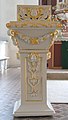
Baptismal font and lectern from 1725
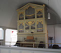
organ


In front of the church in Ostenholz there is a boulder , the so-called Hohe Stein . It has long been known as the " Giant of Hanglüß " after its place of discovery, a hill near Hanglüß. It weighs around 230 tons . An inscription names the places that had to give way to the military training area.
literature
- Hinrich Baumann: The Heidmark - Change of Landscape: The History of the Bergen Military Training Area. Oerbke 2005, ISBN 3-00-017185-1 .
- Hans Stuhlmacher : The Heidmark. Publisher CM Engelhardt, Hanover 1939
Web links
Individual evidence
- ↑ Ostholz Church
- ^ Noeske organ in Ostenholz
- ↑ Hanglüß was a village in the former municipality of Obereinzingen
Coordinates: 52 ° 46 ′ 31.58 " N , 9 ° 43 ′ 20.24" E