
Meiße
| Meiße | ||
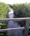
 The Meisse at Gut Sunder, straightened and deepened |
||
| Data | ||
| Water code | EN : 4892 | |
| location | Germany , ( Lower Saxony ) | |
| River system | Weser | |
| Drain over | Aller → Weser → North Sea | |
| source | south of Wietzendorf in the Great Moor 52 ° 52 ′ 5 ″ N , 9 ° 58 ′ 14 ″ E |
|
| Source height | 73 m above sea level NHN | |
| muzzle | in Hodenhagen Coordinates: 52 ° 45 '34 " N , 9 ° 34' 59" E 52 ° 45 '34 " N , 9 ° 34' 59" E |
|
| Mouth height | 21 m above sea level NHN | |
| Height difference | 52 m | |
| Bottom slope | 1.2 ‰ | |
| length | 42 km | |
| Catchment area | 279 km² 381 km² without hydraulic engineering interventions |
|
| Discharge at the Meißendorf A Eo gauge : 109 km² Location: 20.2 km above the mouth |
NNQ (09/27/2009) MNQ 1997–2012 MQ 1997–2012 Mq 1997–2012 MHQ 1997–2012 HHQ (10/26/1998) |
470 l / s 600 l / s 1.07 m³ / s 9.8 l / (s km²) 5.01 m³ / s 10.1 m³ / s |
| Discharge at the mouth of the A Eo : 279 km² |
MQ Mq |
2.3 m³ / s 8.2 l / (s km²) |
| Left tributaries | Berger Bach, Geltteichsgraben, Bruchgraben | |
| Right tributaries | Mühlenbach, Liethbach (from Forellenbach and Schwemmbeck), Meierbach, Hohe Bach, Krusenhausener Bach | |
| Communities | Bleckmar , Hasselhorst , Belsen , Hörsten, Gudehausen, Hartmannshausen , Meißendorf , Hodenhagen | |
The Meiße is a 42 km long right tributary of the Aller in Lower Saxony (south-western Lüneburg Heath ).
Origin and course


The Meiße rises south of Wietzendorf in the nature reserve Großer Moor near Becklingen . After the penultimate Ice Age , the Saale Cold Age , today's upper Wietze was still the upper reaches of the Meiße. Today's sharp eastward turn of the Wietze near Wietzendorf was the result of a river tapping as a result of receding erosion towards the parallel but deeper flowing Örtze. The Meiße flows through Bleckmar , Hasselhorst ( community-free area Lohheide ), Belsen , Hörsten, Gudehausen and Hartmannshausen (all three belong to the community-free district Lohheide), as well as through Meißendorf and flows into the Aller after around 42 kilometers south of Hodenhagen .
The Berger Bach , which flows through the town of Bergen , the small Geltteichsgraben and the Bruchbach , which rises in the area of the Meißendorfer Teiche , flow from the left at Belsen . Right tributaries are the small Mühlenbach near Bleckmar and the Liethbach , which arises near Bredebeck (municipality-free district Lohheide ) from the confluence of the Forellenbach and Schwemmbeck. The Schloss Bredebeck guest house used by the British is located on Liethbach (part of the Bergen-Hohne camp), which also housed members of the British royal family . Shortly before Hodenhagen, two large, natural streams flow from the right, which arise at the heights of the Falkenberg terminal moraine on the Bergen military training area and flow only around 250 meters apart for the last 3 kilometers. The Meierbach is dammed in the 700 meter long Meiersee, and the seven stone houses are in the valley of the Hohe Bach . Shortly before the confluence with the Aller, the Hudemühlen Meiße branches off to the left and, with the main arm, encloses the nucleus of the testicle, the slightly elevated Brink with patches of Hudemühlen and the former castle.
The Meiße has predominantly the water quality of the water quality class II: moderately polluted (betamesosaprob). The section near Hasselhorst, on the eastern edge of the Bergen military training area, has the water quality class II - III: critically polluted.
use
Hydraulic changes in the river system
The Meiße river system consists of drainage lines that come down from the southern slope of the Falkenberg terminal moraine and collect in a lowland that is separated from the Aller glacial valley by a long, narrow inland dune . The large raised bogs and the dunes hinder the runoff, so that extensive canal construction has been carried out to drain the area. The Esseler Canal crosses the Meiße north of the Allertal motorway service station ( A7 , E 45). It arises from the north and south canals , both of which drain the Ostenholz Moor . Before it flows into the Aller near Hademstorf , it is reinforced by the Untere Drebber , which follows the northern edge of the dunes. All these waters belong to the original catchment area of the Meiße, which was reduced by around 41 km² through the construction of these canals. Further up, the Allerplackgraben also leads to the Obere Drebber at Bannetze der Aller; this reduced the catchment area by a further 61 km². The mean water flow of the Meiße at the mouth was reduced from around 3 m³ / s to around 2.3 m³ / s.
Pond management and renaturation

As early as 1881, at Gut Sunder, work began on deepening and damming the Meiße in order to operate pond management. Over time, fish ponds were created on 250 hectares. Today these form part of the Meißendorfer Teiche / Bannetzer Moor nature reserve . A water mill with a sawmill was also operated here until the 1970s. In the area, ponds were created on an additional 250 hectares. At Gudehausen (municipality-free district of Lohheide) the Herrengraben was dug, which supplies many of these ponds with water. In 1998 the district of Celle began to renaturalize parts of the Meiße . In the west of the Sunder estate, an approximately 900 m long section was passed through a naturally designed bed and the previously straightened and deepened section of the stream was preserved as still water . In the area of the Bergen military training area, extensive renaturation measures have been carried out over almost three kilometers on the upper reaches of the Meiße and its tributaries, the Liethbach and the Berger Bach. The measures are intended to restore ecological continuity. Various ponds were gradually drained. Among other things, the ponds of the Liethbach, northwest of Bredebeck Castle , and the Hoppenstedt pond, at the confluence of the Berger Bach and Meiße rivers on the western edge of the barracks area. Near-natural stream structures were created in the pond floor. The stream bed was partially narrowed to increase the flow rate. Gravel banks were installed and trees removed. A railway embankment and a high weir with a fall height of more than two meters had to be demolished. Brown trout , Mühlkoppen and brown lamprey have already settled again. In the long term, river lampreys , sea trout and salmon are expected to spawn here again . With these measures, the Meiße entertainment association took part in the Lower Saxony water competition “Bach im Fluss” in 2012 and was awarded the “Silver Bach Pearl” as 2nd prize .

The Meiersee at the Bergen military training area

The Meiße near Bleckmar
The renatured Meiße near the Meißendorfer ponds

The Meiße oxbow lake as still water

Location of the former Hodenhagen Castle in a wood on the Meiße


swell
- ↑ Today's catchment area is reduced by around 102 km² due to the Esseler Canal and Allerplackgraben (measurement in TK 25)
- ↑ Water science yearbook Weser-Ems 2012
- ↑ Gauge value Meißendorf , increased by the drainage of the 170 km² remaining catchment area (mean value from the intermediate catchment area of the gauges Celle , Wathlingen , Aligse , Feuerschützenborstel , Wieckenberg and Marklendorf (5 l / s km²) and gauge EZG Meißendorf (9.8 l / s km²) )).
- ↑ Description of the NSG Großes Moor near Becklingen v. NLWKN
- ↑ Water quality class
- ↑ On the history of Gut Sunder
- ↑ Water competition "Bach im Fluss"