
Düshorn
|
Düshorn
City of Walsrode
|
||
|---|---|---|
 |
||
| Height : | 49 m above sea level NN | |
| Area : | 25.4 km² | |
| Residents : | 2200 (2008) | |
| Population density : | 87 inhabitants / km² | |
| Incorporation : | March 1, 1974 | |
| Postal code : | 29664 | |
| Area code : | 05161 | |
Location of Düshorn in Lower Saxony |
||
_-_02.jpg) The wooden bell tower of St. John the Baptist Church in Düshorn
|
||

Düshorn is a district of the city of Walsrode in the Heidekreis district ( Lower Saxony ).
geography
Düshorn, the largest village in the city of Walsrode, is located 4 km southeast of the core area of Walsrode and 5 km north of the Walsrode motorway triangle. With an area of 25.4 km², Düshorn has around 2200 inhabitants.
The districts of Beetenbrück, Ellinghausen and Rödershöfen belong to Düshorn, which was an independent municipality until the territorial reform of 1974 .
history
The name is derived from the historical name "Dußhorne" (1st part: duss = light, white moor; light = flat, white = from the cotton grass that covered the marshy landscape; 2nd part: horn = from the shape of the place like the Urhorn).
In a description of the former home keeper of the Fallingbostel district, Hans Stuhlmacher (Schneeheide), the place name is interpreted as follows: Düshorn was first mentioned in 1227 as Dushorne . In the old place name, “Dus” stands for “gloomy”, “horn” for hill, maybe also for Tweshorn.
In 1627, during the Thirty Years' War , 13 houses burned down in Düshorn. In Rethem (Aller) , about 17 kilometers to the west, was the headquarters of the imperial troops under Tilly . Whitsun 1637, the place was reduced to rubble again. Only three houses remained.
Around 1730 the “Düshorner Gesundbrunnen” was well known. At that time there was a belief that the water in the well helped with eye problems.
The name Beetenbrück probably refers to the original form of beet , which is seed land.
The annals of the Braunschweig-Lüneburgische Churlande reported about a fire disaster in Düshorn in 1794 :
“The accident of 1794.
On January 26th, two houses and three outbuildings burned down in Eltze, Meinersen District. On February 1st, three houses and three outbuildings in Düshorn in the Amtsvoigtey Fallingbostel had the same fate. "
In a devastating fire in 1824, 71 buildings in the town fell victim to the flames. The Celler Stadt physikus Medical Councilor Dr. Friedrich Ludwig Andreas Koeler (1773–1836) announced in the “Zellesches Anzeiger plus contributions” on July 7, 1824: “Cell. For the burned down in Düshorn I also received and sent it to the Fallingbostel office : From an unnamed 2 rT Conv. Coin. From an unnamed giver 2 rT 16 ggr. In cash two -thirds. Another half a pistol from an unnamed giver. M. R. Dr. Koeler. "
The burned down farms were mainly rebuilt on the outskirts and eight farmhouses on the Kamp opposite the school - all of the same design. The bell tower was built away from the church in 1827.
After the Second World War arose settlements "On crooked angle" and "settlement beds bridge". In 1970 the "Pascheberg" and "Ellinghäuser Straße" were built. The “Kapellenkamp” and “Kotte Kamp / An der Obstbaumwiese” building areas have been completed in recent years.
On March 1, 1974, Düshorn was incorporated into the city of Walsrode.
politics
The mayor is Matthias Schünemann.
The village of Düshorn is the only Walsroder district that still has its own municipal office (open two days a week by the hour).
coat of arms
Düshorn is the only village in the Walsroder urban area that is allowed to have its own coat of arms . Water and heather sand, blue and yellow, are the basic colors of the coat of arms. The horn indicates the original shape of the village, the waves of the lido.
Culture and sights
- The Church of St. John the Baptist . A special feature of the church is a baptismal angel , which still fulfills its function in worship .
- The Düshorn Village Museum is located in the former town hall of the Düshorn community on Kirchstrasse.
- The biotope with ponds and orchards invites you to take a walk.
- In Uhlenbusch are tumuli signposted.
The Düshorner See directly on the A 27 invites you to swim in summer . It was created when the motorway was built and is now used as a bathing beach. In 2004 an association was founded to organize the operation and maintenance of the lido in the village of Düshorn.
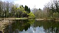
Weddenwiesen biotope

House by the forest
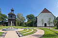
The Church of St. John the Baptist
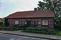
Old town hall, today the village museum

Town view


_IMG_8707.jpg)
_IMG_8712.jpg)
_IMG_8716.jpg)
See also the list of architectural monuments in Düshorn
Economy and Infrastructure
education
traffic
Düshorn is far away from major traffic, which increases the quality of living. The next federal highway , the B 209 , runs 4 km north through Walsrode and creates good connections in east-west direction to Nienburg / Weser and Soltau .
The Walsrode motorway triangle is 5.5 km to the south. There are very good connections to the A 27 to the north (to Bremen ) and to the A 7 to the north (to Hamburg ) and to the south (to Hanover and thus also to the A 2 ).
Two well-developed main roads (the state road 163 and the district roads 148 and 146) cut through the core town of Düshorn and divide it into different areas:
- the "Fallingbosteler Straße" (L 163) runs northeast to Bad Fallingbostel
- the "Fallingbosteler Straße" / Straße "Auf dem Kamp" (L 163) runs southwest to Beetenbrück
- the "Walsroder Straße" (K 148) runs northwest to Walsrode
- the "Celler Straße" (K 148) runs east to Bockhorn
- the "Mühlenstraße" (K 146) runs southeast to Krelingen
In Düshorn and in the Beetenbrück settlement the streets have names, in the districts of Ellinghausen and Rödershöfen there are only house numbers. So here the place name is also the street name.
The nearest train station is the Walsrode train station on the Hanover- Soltau line . It is approx. 4 km to the northwest from Düshorn. Düshorn had its own train station, which is no longer served by the Heidebahn railcars . It was located in the Beetenbrück settlement about 3.6 km from the town center and had practically no catchment area of its own . The station building and the freight yard are still there, but tied off the route .
Personalities
- Ludwig Rahlfs (1863–1950), composer, music teacher and teacher. He spent his youth in Düshorn. Rahlfs is the composer of the song " Auf der Lüneburger Heide " a. a.
literature
- Heike Frewer: Photo book Düshorn. 1870-1960. ISBN 3-00-008095-3 .
- Franz Ohlhoff: Chronicle of Düshorn and its districts Rödershöfen, Ellinghausen and Beetenbrück. Düshorn community, Düshorn 1970.
- Hans Stuhlmacher : The district Fallingbostel - A home book of the district. Art print and publishing office, Magdeburg 1935.
Web links
Individual evidence
- ↑ On the territorial reform cf. Matthias Blazek: From Landdrostey to District Government - The history of the Hanover District Government as reflected in the administrative reforms. Stuttgart 2004, ISBN 3-89821-357-9 .
- ↑ Local researcher Hans Stuhlmache, Schneeheide: "Heidmark" p. 37
- ^ Annals of the Braunschweig-Lüneburgischen Churlande. Ninth year, first piece, Hanover 1795, p. 473.
- ↑ In detail: Matthias Blazek: Das Löschwesen in the area of the former Principality of Lüneburg from the beginnings to 1900. Adelheidsdorf 2006, ISBN 3-00-019837-7 , p. 190.
- ^ Federal Statistical Office (ed.): Historical municipality directory for the Federal Republic of Germany. Name, border and key number changes in municipalities, counties and administrative districts from May 27, 1970 to December 31, 1982 . W. Kohlhammer GmbH, Stuttgart and Mainz 1983, ISBN 3-17-003263-1 , p. 225 .
Ahrsen | Altenboitzen | Benefeld | Benzene | Bockhorn | Bomlitz | Pompons | Borg | Düshorn | Ebbingen | Fulde | Groß Eilstorf | Hamwiede | Hollige | Honerdingen | Hünzingen | Idsingen | Jarlingen | Kirchboitzen | Klein Eilstorf | Krelingen | Kroge | Nordkampen | Snow heather | Sieverdingen | Stellichte | Südkampen | Uetzingen | Vethem | Westenholz