
Bockhorn (Walsrode)
|
Bockhorn
City of Walsrode
Coordinates: 52 ° 49 ′ 41 ″ N , 9 ° 40 ′ 18 ″ E
|
||
|---|---|---|
| Height : | 76 m | |
| Area : | 9 km² | |
| Residents : | 290 | |
| Population density : | 32 inhabitants / km² | |
| Incorporation : | March 1, 1974 | |
| Postal code : | 29664 | |
| Area code : | 05162 | |
Location of Bockhorn in Lower Saxony |
||

Bockhorn is a district of the town of Walsrode in the Heidekreis district in the Lüneburg Heath in Lower Saxony . About 290 inhabitants live in the heath village on an area of 9.0 km².
geography
Bockhorn is located in the south-east of the city of Walsrode, 7 km south-east of the core town of Walsrode and 2.5 km east of Düshorn. In the eastern area, the place borders directly on a large military training area .
Neighboring communities are - clockwise from the north - Bad Fallingbostel , Fahrenholz , Krelingen and Düshorn .
history
Bockhorn was first mentioned in a document in 1237 . The name "Bockhorn" is derived from the location of the place. The syllable "boke" means beech , the syllable "horn" means corner or hill. Old beeches and oaks still stand on the Bockhorner Höfe and shape the appearance of the village.
In the course of the construction of the Bergen military training area , most of the Deil farm , which belonged to the municipality of Bockhorn, was cleared . The farm owners were compensated. The courtyard was incorporated into the nearby Oerbke barracks , and the buildings were then used as the officers' mess. The total size of the Bockhorn municipal area was 977 hectares , 72 hectares of which fell into the military training area.
Since the regional reform in Lower Saxony , which came into force on March 1, 1974, the previously independent municipality of Bockhorn has been one of 23 localities in the city of Walsrode.
politics
Ulrich Voss is the head of the village.
Culture and sights
The over 9 hectare unique ginseng gardens of the FloraFarm on the edge of the village are the only place in Europe where Korean ginseng has been professionally grown and marketed for almost 30 years.

Bockhorn

Bockhorn

FloraFarm, Bockhorn
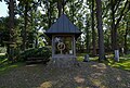
Bockhorn clock

Town view


_IMG_8721.jpg)
_IMG_8720.jpg)
see also the list of monuments in Bockhorn
Economy and Infrastructure
The federal motorway 7 runs 1 km east of Bockhorn and the Walsrode motorway triangle is 4 km south. Of Bad Fallingbostel about Walsrode and Rethem to Nienburg leading national highway 209 runs 3.5 km north.
In Bockhorn there are no street names, only house numbers that residents, postmen, vendors and visitors have to use for orientation.
Web links
Individual evidence
- ↑ On regional and administrative reform in Lower Saxony, cf. Blazek, Matthias: From the Landdrostey to the district government - The history of the district government Hanover as reflected in the administrative reforms, ibidem-Verlag, Stuttgart 2004, ISBN 3-89821-357-9 .
Ahrsen | Altenboitzen | Benefeld | Benzene | Bockhorn | Bomlitz | Pompons | Borg | Düshorn | Ebbingen | Fulde | Groß Eilstorf | Hamwiede | Hollige | Honerdingen | Hünzingen | Idsingen | Jarlingen | Kirchboitzen | Klein Eilstorf | Krelingen | Kroge | Nordkampen | Snow heather | Sieverdingen | Stellichte | Südkampen | Uetzingen | Vethem | Westenholz