
Kircher farmers
|
Kircher farmers (KB)
Isernhagen municipality
|
||
|---|---|---|
 |
||
| Height : | 73 m above sea level NHN | |
| Area : | 8.05 km² | |
| Residents : | 1670 (December 31, 2018) | |
| Population density : | 207 inhabitants / km² | |
| Incorporation : | March 1, 1974 | |
| Incorporated into: | Warmbüchen | |
| Postal code : | 30916 | |
| Primaries : | 0511, 05139 | |
Location of Kircher Bauerschaft (KB) in Lower Saxony |
||
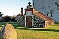
 View of the place and church
|
||

The Kircher Bauerschaft (KB) is a district of the municipality of Isernhagen in the Hanover region in Lower Saxony .
geography

The district of Kircher Bauerschaft stretches in the middle of the six other districts of Isernhagen on a slight hill along the Dorfstrasse (K 113) and is surrounded by fields, meadows and small forests.
history
The Kircher peasantry is a place that was laid out as an elongated Hagenhufendorf village as early as the Middle Ages . The place name is derived from the church (Sankt-Marien) built in the 15th century. The designation as a peasantry is based on the economic form of Burschap (peasantry) that is common in Low German areas .
On March 1, 1974, the community of Isernhagen, Kircher peasantry was incorporated into the new community of Warmbüchen. This was officially renamed Isernhagen on June 1, 1975 .
politics
Local council
The local council consists of a councilwoman and four councilors. The local council also has an advisory member (CDU).
(Status: local election September 11, 2016)
Local mayor
The local mayor of the Kircher peasantry is Matthias Kenzler (FDP). His deputy is Christian Schröder (CDU).
coat of arms
The draft emblem of Kircher peasantry comes from the in Isernhagen born and later in Hannover living heraldry and crest painter peoples Gustav , who has the coat of arms of Großburgwedel , Melle village , Wunstorf has designed and many other towns. The award of the coat of arms was carried out on November 22, 1954 by the Lower Saxony Minister of the Interior .
|
|
Blazon : “A blue , right sloping beam in silver , covered with four upright, mutually covering, silver horseshoes . In the upper corner there is a sloping, green hop fruit to commemorate the hop cultivation that was practiced here in earlier centuries. " |
| Founding of the coat of arms: The name Isernhagen is evidence of iron ore deposits that were proven to have been exploited here as early as around the year 900. This is what the horseshoes indicate. They should also remind you that horse breeding has been practiced successfully in Isernhagen for a long time. The number of four horseshoes was chosen to show the close ties between the independent political communities that make up a parish and a settlement unit. The blue, right sloping bar is supposed to symbolize the river Wietze . The coats of arms of the four municipalities must be viewed together, especially since the municipalities tried very hard to give themselves a uniform coat of arms. At the request of the Lower Saxony Minister of the Interior, however, each municipality had to include a distinctive symbol in its coat of arms. |
Culture and sights

Buildings
The townscape is characterized by a large number of well - kept half-timbered houses and farms as well as the St. Mary's Church on the hill.
- The Sankt-Marien-Kirche stands both in the center of the church community and in Isernhagen and is visible from afar in the region. It was the mid-15th century from bog iron built, the tower around 1500. The garb of his brick portals are made form bricks formed. In the course of the Reformation , the parish became Evangelical Lutheran around 1534 .
- The tomb from 1788 at the Sankt-Marien-Kirche in Isernhagen was built by Colonel of the royal dragoon regiment Friedrich von Hattdorf (1725–1789) and is now a listed building.
- The townscape is characterized by a large number of very old, well-kept half-timbered houses and farms, which have often been redesigned for modern use.
Architectural monuments
→ See: List of architectural monuments in Kircher farmers
Photo gallery

Half-timbered house from 1709

Half-timbered village Haghof

Half-timbered house from 1700
Tomb of Colonel Hattdorf from 1788 at the Sankt-Marien-Kirche
_Isernhagen_KB.jpg)

_in_Isernhagen_KB.jpg)

literature
- Heinz Koberg : Our Isernhagen . Ed .: Municipality of Isernhagen. March 1984.
- Claudia Kempf-Oldenburg, Jes Tüxen: Isernhagen Chronicle . Ed .: Municipality of Isernhagen. tape December 1 , 1990.
- Claudia Kempf-Oldenburg, Jes Tüxen: Isernhagen Chronicle . Ed .: Municipality of Isernhagen. tape December 2 , 1992.
Web links
Individual evidence
- ↑ a b Facts and Figures. In: Website of the community Isernhagen. December 31, 2018, accessed April 17, 2019 .
- ^ Federal Statistical Office (ed.): Historical municipality directory for the Federal Republic of Germany. Name, border and key number changes in municipalities, counties and administrative districts from May 27, 1970 to December 31, 1982 . W. Kohlhammer, Stuttgart / Mainz 1983, ISBN 3-17-003263-1 , p. 222 .
- ^ Federal Statistical Office (ed.): Historical municipality directory for the Federal Republic of Germany. Name, border and key number changes in municipalities, counties and administrative districts from May 27, 1970 to December 31, 1982 . W. Kohlhammer, Stuttgart / Mainz 1983, ISBN 3-17-003263-1 , p. 197 .
- ↑ a b Local council of the church farmers. In: Website of the community Isernhagen. Retrieved August 14, 2017.
- ↑ a b District Hanover: Wappenbuch district Hanover . Published by the author himself, Hannover 1985, p. 202-203 .
Altwarmbüchen |
Farster Farmers (FB) |
Hohenhorster peasantry (HB) |
Kircher farmers (KB) |
Kirchhorst |
Neuwarmbüchen |
Niedernhägen farmers (NB)