
Altwarmbüchener See
| Altwarmbüchener See | ||
|---|---|---|
.jpg)
|
||
| Altwarmbüchener See, with a view of the Hannover-Lahe landfill , in between the BAB 37 and on the right the BAB 2 | ||
| Geographical location | Hanover , Isernhagen , Lower Saxony | |
| Location close to the shore | Hanover | |
| Data | ||
| Coordinates | 52 ° 25 '23 " N , 9 ° 51' 17" E | |
|
||
| surface | 48 ha | |
| length | 1.53 km | |
| width | 440 m | |
| Maximum depth | 12 m | |
| PH value | 4.5 | |
|
particularities |
Quarry pond |
|

The Altwarmbüchener See is a 48-hectare man-made lake, three quarters of which is located in the city of Hanover and the rest in the municipality of Isernhagen . It was created during the construction of the Autobahn 37 (BAB 37) at the end of the 1970s. Today, as the second largest lake in Hanover, it is the core of a local recreation area on the Altwarmbüchener Moor with numerous recreational opportunities, especially swimming.
history
The inauguration of the lake took place in June 1982. It was created between 1978 and 1981 through sand washes that were removed to fill the route for the BAB 37 . The motorway running through the middle of the Altwarmbüchener Moor (therefore also called the moor motorway) runs about 200 m southeast of the lake, the BAB 2 at the same distance southwest of the lake. The moor vegetation around today's lake was damaged over centuries by peat extraction and drainage. In the first decades of the 20th century there were backfills with excavated soil from the construction of the Mittelland Canal , and in 1937 the Lahe landfill was established. In order to promote the landscape of the Altwarmbüchener Moor in terms of nature conservation, the landfill dumps were greened and the lake was created as part of the motorway construction.
description
The lake has the dimensions of 1,500 m length and a max. Width of 450 m. The depth is 7–12 m. It represents the core of a 150 hectare recreational area on the edge of the Altwarmbüchener Moor, a formerly 15 km² high moor . Three quarters of the lake is in the urban area of the planning and executing city of Hanover and the northern quarter in the area of the municipality of Isernhagen . On the northern bank of the river there are two sandy beaches supervised by the German Life Saving Society (DLRG), one in Hanover and one in Isernhagen. In the area of Isernhagen there is also a wooded island that is designated as a bird sanctuary . The lake is hardly populated by fish, as its water is rich in iron and resembles an acidic heather lake. The few species of fish that occur include perch , pike and whitefish. The water area is surrounded by play and sunbathing areas and a 3.5 km long circular path. In addition to swimming on sandy beaches, there are leisure activities such as playing, camping, sailing, rowing and surfing. In the northeast area, the moor with its birch quarry forest extends as far as the lake. The edge areas of the lake are of great importance for nature conservation. The following facilities are available:
- Service building of the city of Hanover
- DLRG station
- Sailing school
- Boat rental
- WSV Altwarmbüchen eV (rowing and sailing)
Picture gallery
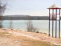
Lake with a beach, on the horizon of the garbage mountain Monte Müllo the landfill Hannover

Sailboats on the shore, July 2010

View over the lake, March 2009
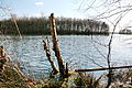
Island view, March 2009


See also
Web links
- Description at the municipality of Isernhagen
- Description at hannover.de
- Description, pictures and map to Altwarmbüchener See
- Bathing water atlas Lower Saxony: Altwarmbüchener See
- www.anglermap.de: Water profile Altwarmbüchener See
Individual evidence
- ↑ Bathing water atlas Lower Saxony: Altwarmbüchener See (accessed on November 6, 2014)