
Langenberg (Bad Harzburg)
| Langenberg | ||
|---|---|---|
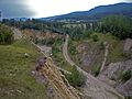
 The Langenberg from the north (2017) |
||
| height | 304 m above sea level NHN | |
| location |
Göttingerode / Harlingerode , district of Goslar , Lower Saxony ( Germany ) |
|
| Mountains | Northern Harz foreland | |
| Dominance | 0.7 km → Tönneckenkopf in Göttingerode | |
| Coordinates | 51 ° 54 '9 " N , 10 ° 30' 33" E | |
|
||
| rock | limestone | |
| Age of the rock | Kimmeridgium | |
| particularities |
|
|


The Langenberg is one to about 304 m above sea level. NHN high ridge of the northern Harz foreland and part of the Harz north rim fault between Harlingerode and Göttingerode in the Lower Saxony district of Goslar . Its exemplary visibility of the North Harz Fault and the discovery of the Europäischeaurus holgeri at the Langenberg limestone quarry give the elevation a supraregional geological and archaeological significance.
geography
location
The Langenberg rises in the northern Harz foreland in the north of the Harz Nature Park . Its summit, on which there is a summit cross, is known as the "Franzosenkopf". The mountain lies on average 1.1 km south of Harlingerode , 1.1 km west of Schlewecke with the Gläsecke flowing through this village , which flows a little further northeast into the Radau , and 0.7 km north of Göttingerode , all of which are part of the city Bad Harzburg relate, and 2.7 km east of the Oker carrying Oker , the to the city of Goslar counts. To the south, the landscape leads through the valley of the Oker tributary Röseckenbach to the northern roofing of the Harz low mountain range and to the southeast through that of the Radau to the Butterberg (approx. 325 m ) about 4.5 km (as the crow flies ) from the peak . The Hurlebach rises on the site of the Hansa mine on the northern slope.
Natural allocation
The Langenberg belongs to the natural spatial main unit group Northern Harz foreland (No. 51), in the main unit Harzrandmulde (510), in the subunit Harzburger Harzvorland (510 1 ) and its sub-area foothills of the northern Upper Harz (510 1 .4) to the natural area Harzburg-Goslarer Vorberge (510 1 .40).
Mountain height
The Langenberg is about 304 m high; this height stands for the mountain summit north of a former quarry (see below ) of the west knoll. Some maps only show 298 m ; however, this height only refers to the eastern summit. Further details are 289 m or 290 m ; this information stands for the height indication "289.3" on the elevations of the elevation, which can be seen from some topographic maps .
history

The name Langenberg is self-explanatory; its elongated Hercynian shape, parallel to the Harz Mountains to the south, gives the mountain a characteristic profile. Until the end of the 20th century, this continued to stand out due to the contrast of the forest, as the Langenberg was almost treeless compared to the mountains in the Hochharz.
Between 1285 and 1296 the "silva Langenberg" and 1309 "the Langenberch" are described as belonging to the Goslar cathedral monastery, to which the main courtyard in Harlingerode also belonged at that time. In the first document dated November 13, 1285, the power of the cathedral monastery was formally recognized by the Duchy of Braunschweig and the land was ascribed to it. The western part of the Langenberg fell administratively to Harlingerode, while the smaller, eastern part was slammed into Schlewecke. Later both areas went into the territory of the state of Braunschweig.
Alt- Göttingerode , south of the mountain, fell desolate at the end of the 15th century.
In the course of modern times, the Langenberg was cleared more and more, so that in 1820 it was completely free of trees and dominated by fields and meadows for the Bündheim stud farm . This condition was to be maintained for around 150 years until a greening project was carried out on the initiative of the then Harlingerode am Langenberg in the middle of the 20th century.
The Langenberg wrote its first mining history with the opening of the Hansa mine in 1861, which found profitable iron ore deposits in the Bad Harzburg district as part of an investigation from 1859 to 1861. It closed in 1960 due to the exhaustion of the ore deposits. In 1871 the Langenberg limestone quarry was opened on the western edge as part of the Oker lime works.
In 1935, Göttingerode was re-established as a National Socialist model settlement. During the same period, the lime works was fundamentally restructured, which lasted into the 1950s and led to increasing mining of the lime deposits on the southern edge. However, the traces of centuries of mining left the Langenberg in a desolate state: When the Hansa pit was dismantled, the surface looked like a crater landscape, which was later filled with waste and then leveled.
Until the 1960s, an approximately 700 meter long aisle was dug into the Langenberg, which, according to further plans, would have continued to the outskirts of Schleweck and divided the Langenberg in two. After various legal proceedings up to the Lower Saxony Higher Administrative Court , the plans were finally dropped in 1985, the active demolition operation was ended due to the exhaustion of capacity. The demolition plans were also the reason for the establishment of the Östlicher Langenberg nature reserve in 1987.
In 1999, a hobby archaeologist discovered the Europäischeaurus in the limestone quarry . Other finds, mainly from Upper Jurassic, followed. Until about 2005 the establishment of a "Jurapark Harz" in Langenberg was considered.
On April 20, 2019, a summit cross was erected on the Franzosenkopf.
Landscape image

The northern slope of the partially wooded Langenberg initially drops steeply, with the exception of a small shrub plain without any obstacles from the beginning of the slope at about 260 m above sea level to the southern edge of Harlingerode at 230 m above sea level. After this slope, the elevation goes over to around 230 to 220 m in the southern part of the village. There the slope continues to drop to a height of 190 m on the northern edge of the village, to which agriculturally used areas adjoin. Further north this slope merges into the Harzburg foothills of the Harz, from which the landscape between Oker and Radau leads north to the hill of the Harly Forest .
On the southern edge, the Langenberg slopes gently from a height of 280 m , but not below 270 m to Göttingerode . Further south, the town joins the small depression that the Old Auerbergland belonging Okerhochfläche , which for high resin leads over.
Protected areas
The nature reserve (NSG) Östlicher Langenberg ( CDDA No. 164966; designated in 1987; 28 hectares in size) is located on high altitude areas along the ridge line from the eastern part of the Langenberg . To the north and south of this is the two-part landscape protection area of Ostlicher Langenberg (CDDA no. 323587; 1984; 45 ha). The NSG Tönneckenkopf – Röseckenbach (CDDA no. 82727; 1988; 20 ha) extends to the southern foot of the western part of the mountain .
Quarry
The Langenberg in the west houses a quarry that has been closed since the late 1990s .

Harz north rim fault in the area of the Langenberg
Overgrown eastern flank of the quarry

West view towards Sudmerberg and zinc hut Harlingerode

.jpg)

Transport, hiking and leisure
The county road 70 ( Oker - Harlingerode - Schlewecke ) in the north and the state road 501 (Oker - Göttingerode - Schlewecke ) lead past Langenberg in a west-east direction . Both roads are connected by a narrow side road that runs south from Harlingerode to Göttingerode and passes a trigonometric point at a height of 272 m between the west and east crests of the elevation near the highest point of the road . The street Am Langenberg , located in Harlingerode in a residential area, is named after the survey .
For example, starting at these roads, the Langenberg can be hiked on several paths, some of which have signs indicating the nature reserve Östlicher Langenberg . On the summit region, where there are several banks, there are often good conditions for flying a kite . The north slope towards Harlingerode is often used for tobogganing , as there are no natural obstacles in the way, apart from a small shrub plain.
The western slope of the Langenberg is still used today for unloading rubble. Large areas are misused by motorcyclists as an off-road route, as the well-developed paths of the former quarry and the good view of the Harz Mountains, the Oker-Harlingerode industrial area and the Sudmerberg are a unique selling point.

Web links
- Detailed description ( Harzburg hiking site , private)
- The Langenberg and the former Oker lime works. (Photos), on photos.google.com
Individual evidence
-
↑ a b c Berghöhe (Westkuppe) according to Der Große Falk Atlas - Germany detailed maps. M = 1: 200,000, 2004/2005, ISBN 3-8279-0381-5 .
Compare with: Lower Saxony Navigator ( Memento of the original from June 22, 2013 in the Internet Archive ) Info: The archive link was inserted automatically and has not yet been checked. Please check the original and archive link according to the instructions and then remove this notice. (see height indication "304" in medium magnification). - ↑ Jürgen Spönemann: Geographical Land Survey: The natural spatial units on sheet 100 Halberstadt. Federal Institute for Regional Studies, Bad Godesberg 1970. → Online map (PDF; 4.7 MB)
- ↑ Berghöhe (Ostkuppe) according to the topographical map of Langenberg ( Memento of the original from October 29, 2013 in the Internet Archive ) Info: The archive link has been inserted automatically and has not yet been checked. Please check the original and archive link according to the instructions and then remove this notice. (DTK 25; see large enlargement of the map), on natur-erleben.niedersachsen.de
- ↑ Richard Wieries: History of the Harzburg Office after its forest, field and street names . Appelhans, Braunschweig 1937, p. 72 f . ( Online publication of the TU Braunschweig ).
- ↑ a b Map services of the Federal Agency for Nature Conservation ( information )