Eastern Langenberg
|
Eastern Langenberg
|
||
| location | Northwest of Bad Harzburg , east of Goslar | |
| surface | 28 ha | |
| Identifier | NSG BR 083 | |
| WDPA ID | 164966 | |
| Geographical location | 51 ° 54 ' N , 10 ° 31' E | |
|
|
||
| Sea level | from 246 m to 289 m | |
| Setup date | 03/17/1987 | |
| administration | NLWKN | |
The eastern Langenberg is a 28 hectare nature reserve designated in 1987 in the Lower Saxony town of Bad Harzburg in the Goslar district . It is on the Langenberg .
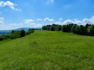
The nature reserve is located in the west of the urban area of Bad Harzburg on the eastern part of the Langenberg between the districts of Harlingerode , Schlewecke and Göttingerode . The mountain is a limestone hill in front of the Harz , whose flat, dry hilltop and part of the south-facing slope are populated by semi- arid grass and heat-loving fringes and bushes. The area is partially divided by hedges . The deep soils on the northern slope of the Langenberg are mainly occupied by grassland . A forestry area can be found in the west of the nature reserve.
Old limestone quarries can be found on the Langenberg , which have developed into secondary rock biotopes with little vegetation . There are several paths that can be used through the nature reserve.
The nature reserve has the registration number NSG BR 083 and is assigned the CDDA no. 164966 led. It has been a nature reserve since March 17, 1987. The responsible lower nature conservation authority is the district of Goslar.
The north and south of the reserve is the two-part conservation area Eastern Langenberg (CDDA No. 323587, designated 1984. 45 ha).


