
Sudmerberg (mountain)
| Sudmerberg | ||
|---|---|---|
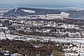
 View from the refuge at the Ammental forester's lodge north-northeast towards the Sudmerberg |
||
| height | 355 m above sea level NHN | |
| location | near Goslar - Sudmerberg ; District of Goslar Lower Saxony ( Germany ) | |
| Coordinates | 51 ° 54 '54 " N , 10 ° 28' 4" E | |
|
||
| particularities | - Sudmerberg Tower - Goslar transmitter |
|

The Sudmerberg is a 355 m above sea level. NHN high mountain of the northern Harz foreland . It is located in the Goslar district of Sudmerberg in the district of Goslar am Harz in Lower Saxony .
The Sudmerberg Tower (Sudmerberger Warte) and the Goslar transmitter are located on the mountain . A small sandstone quarry was operated on Sudmerberg until around 1960 .
The name Sudmerberg developed from Sudburgerberg , after Sudburg , which was located on the eastern flank in the early Middle Ages .
geography
location
The Sudmerberg extends in the northern foothills of the Harz Nature Park . It separates the Goslar districts of Sudmerberg in the southwest, Oker in the southeast and Steinfeld in the east. The Abzucht flows south past the mountain and flows into the Oker that runs east of it .
In the southwest of the oval-shaped mountain, viewed from a bird's eye view, there is the main peak and in the northeast - west above Steinfeld - a 317 m high secondary peak; both are about 1.3 km apart. The Sudmerberg conservation area is located on the mountain ( CDDA no. 324922; designated in 1966; 1.5 km² in size). The federal highway 498 leads past to the south and branches off in the southwest from the federal highway 6 which passes through the mountain west to north .
Natural allocation
The Sudmerberg belongs to the natural spatial main unit group Northern Harz foreland (No. 51), in the main unit Harzrandmulde (510), in the subunit Harzburger Harzvorland (510 1 ) and its sub-area foothills of the northern Upper Harz (510 1 .4) to the natural area Harzburg-Goslarer Vorberge (510 1 .40). The landscape falls to the northwest to the north in the natural area of Immenroder Schotterfluren (510 1 .12) and to the east in the natural area of Okertal (510 1 .10).
Towers
The Sudmerberg tower, also called Sudmerbergwarte or Sudmerberger Warte , stands on the summit region of the Sudmerberg . The former guard tower made of sandstone and rubble stone was built around 1400 and burned down in 1670 after a lightning strike. It is 12.1 m high and, as a round tower, has a diameter of 5.6 m.
The view of the city of Goslar, the Harz foreland and the Brocken falls from the viewing platform of today's observation tower . The tower is included as no. 108 in the system of stamping points of the Harz hiking pin.
The Goslar transmitter is also located on the summit region .

View from the south to the summit region of the Sudmerberg with the Sudmerberg tower on the left and the transmission tower of the transmitter Goslar

Sudmerberg Tower (Sudmerberger Warte)

Goslar transmitter
View from the Großer Burgberg over to the Sudmerberg


literature
- Friedrich Stolberg: Fortifications in and on the Harz from early history to modern times , Verlag Lax, 1968 (later edition: Hildesheim 1983)
Web links
Individual evidence
- ↑ a b c d Map services of the Federal Agency for Nature Conservation ( information )
- ^ Franz Eduard Volger: Documents from the Bishops of Hildesheim , Hannover 1846, p. 76, on books.google.de
- ↑ Jürgen Spönemann: Geographical Land Survey: The natural spatial units on sheet 100 Halberstadt. Federal Institute for Regional Studies, Bad Godesberg 1970. → Online map (PDF; 4.7 MB)
- ↑ Sudmerbergturm , on warttuerme.de
- ↑ Harzer Wanderadel: stamp point 108 / Sudmerberger Warte , on harzer-wandernadel.de