Sudburg (Goslar)
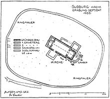
The Sudburg , historically also Sutborch u. ä, was a fortified complex with a settlement and a church on the eastern slope of the Sudmerberg in Goslar-Oker . Documented in the 11th century, it was probably created much earlier. In the 14th century it was abandoned and fell into disrepair. An excavation in 1933 exposed the foundation walls of the church and the wall ring of the churchyard . The excavation field was filled in again.
history
The Sudburg was a base of the royal power in the northern Harz foreland . It belonged to the administrative system of the royal palace Werla , from which it was located to the south - hence the name - and was the seat of the forestarius , the supervisor of the royal forests between Innerste and Ecker . At the same time, it dominated the nearby Oker crossing on the road from Goslar to Halberstadt (today Landesstraße 518).
The church of the Sudburg is mentioned for the first time in a document from Heinrich IV. From 1064, but goes back to a much earlier time. It has been expanded several times. The castle was west of the churchyard. The settlement near the castle was originally called Reindestingerode , but grew together with the castle settlement and was later only named after the castle. The mountain at the foot of which it lay was named after her Sudburgerberg , from which today's name Sudmerberg developed.
Parallel to the Werla Palatinate, the associated Sudburg also lost its strategic and administrative importance. In the High Middle Ages it belonged to the Hildesheim Monastery and was abandoned by the last inhabitants in the 14th century, perhaps in connection with the Welfisch-Hildesheim War in 1367. In the late Middle Ages, the Oker tower of the outer Goslar Landwehr was built near the desert .
The name of the castle path , which connects the castle area with the bank of the Oker at the Abzucht estuary , is reminiscent of the Sudburg .
literature
- Oskar Kiecker, Carl Borchers, Hans Lütgens: Die Kunstdenkmäler der Provinz Hannover , Issue 22, Hannover 1937, pp. 243–244
Web links
- Entry by Stefan Eismann zu Sudburg in the scientific database " EBIDAT " of the European Castle Institute
Individual evidence
- ^ Franz Eduard Volger: Documents from the Bishops of Hildesheim . Hanover 1846, p. 76
- ↑ On the map of the Hochstift from 1643 there is no longer any settlement at the confluence of the Abzucht ("Atugt") with the Oker.
- ^ Thomas Künzel: Monasteries and Cities. Reflections on an ambivalent relationship , p. 19
Coordinates: 51 ° 54 ′ 45.9 " N , 10 ° 28 ′ 56.4" E


