
Harz North Rim Fault

The Northern Harz Boundary Fault , also called northern edge of the Harz rejection or resin northern edge disorder is a geological fault where the from Paleozoic existing rocks and during the Variscan orogeny verfaltete resin to the north to Subhercyne pool adjacent or harzvorland.
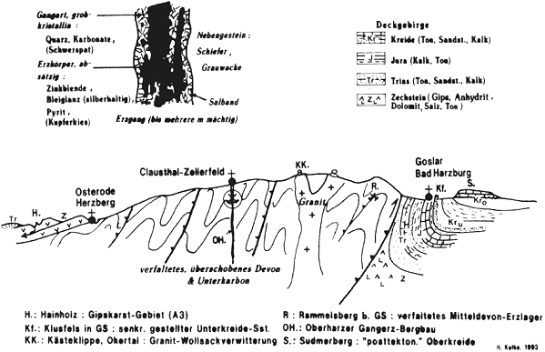
The northern edge of the Harz is Hercynian oriented (WNW-ESE direction) and runs from Neuekrug- Hahausen via Langelsheim , Goslar , Bad Harzburg , Ilsenburg and Wernigerode , Blankenburg , Thale , Gernrode to the Ballenstedt area .
The Harz North Rim Fault represents the southern border of the Northeast German Basin (NEDB), which is part of the Central European Basin (MEB). A small sub-basin of the Northeast German Basin is the Subhercyne Basin, which is also known as the Harz foreland . This intra-continental basin , which has sunk since the Permian , developed from the Variscan foreland basin and absorbed sediments from the Mesozoic Era . The basin was created by stretching the crust or doming the Moho . In the chalk the basin was narrowed by the alpine mountain formation , which also lifted the resin.
The Harz North Rim Fault was activated in the Lower Cretaceous and then the Harz was lifted out of this fault . The resin was pushed onto the Mesozoic layers of the Subhercyne Basin, which made the Mesozoic layers steep and even overturned (see photo). The most intense phase of the uplift occurred in a period of about 2 million years from the central Canton to the Lower Campan . The conclusion of the elevation can be seen from the fact that the rocks of the Upper Cretaceous dip at a much flatter angle than the rocks of the Lower Cretaceous, and in some places they also overlap discordantly . The emphasis continues to this day.
In the western part of the fault, the resin was raised by at least 5 to 7 km, which can be estimated from the thickness of the Mesozoic rocks deposited in the Harz foreland and the eroded Paleozoic rocks. The Harz was partially pushed over the rock layers of the Mesozoic Era to the north . The Mesozoic strata were placed steeply (70–80 degrees) or even overturned. A good example of this is the Langenberg quarry, but there are also many other outcrops that show the steeply upright strata. In this, rocks of the Jura are set steeply. In the vicinity of Blankenburg and Ballenstedt there are steep chalk stones that form the Devil's Wall . This includes Heidelberg sandstone, a silicified ( silicified ) quartz sandstone.
Sources occur in the entire fault system that carry both low-mineralized water and mineral water . The mineral waters are used, for example, in Bad Harzburg for the spa operation and promoted as mineral water in the Okertal (Okertaler Mineralbrunnen GmbH).
The northern edge of the Harz was added to the list of 77 awarded national geotopes in 2006.
literature
- K. Mohr: Harz western part . In: M. Gwinner (Ed.): Collection of geological guides . tape 58 . Borntraeger, Berlin-Stuttgart 1998, ISBN 3-443-15071-3 .
- W. König: Temporal and genetic classification of tertiary sediment occurrences in the Central Harz and in the Harz foreland: A contribution to the relief development and karst morphogenesis in the Harz . Ed .: Dissertation at the Martin Luther University Halle-Wittenberg. 2008.
- Friedhart Knolle , Béatrice Oesterreich, Rainer Schulz and Volker Wrede: The Harz - Geological Excursions . In: Perthes excursion guide . Perthes, Gotha 1997, ISBN 3-623-00659-9 .
- H.-J. Franzke: The Mesozoic field of tension in the Harz region, derived from kinematic fault analyzes . Clausthal Geosciences, Clausthal-Zellerfeld 2006.
- F. Knolle, C. Haase, E. Kapaun, V. Schadach, R. Schulz and W. Wimmer: The Harly - From Wöltingerode to the Muschelkalkkamm . BUND district group Goslar, Goslar 2008, ISBN 978-3-89720-536-9 .
Web links
- Geological overview map of the Harz
- Schematic geological profile through the Harz Mountains and the Harz North Rim Fault
- Detailed profile through the Harz North Rim Fault, Author: H.-J. Franzke
- Geological guide through the Harly
Individual evidence
- ↑ Hans-Joachim Franzke: Classic square mile of geology - the northern edge of the Harz and the devil's wall . In: Ernst-Rüdiger Look, Ludger Feldmann (Ed.): Fascination Geology. The important geotopes of Germany , E. Schweizerbart'sche Verlagsbuchhandlung, Stuttgart 2006, ISBN 3-510-65219-3 , p. 36f.