Lengde
|
Lengde
City of Goslar
|
||
|---|---|---|
| Coordinates: 51 ° 59 ′ 1 ″ N , 10 ° 33 ′ 18 ″ E | ||
| Height : | 129 (122-137) m above sea level NHN | |
| Area : | 9.77 km² | |
| Residents : | 580 (December 31, 2018) | |
| Population density : | 59 inhabitants / km² | |
| Incorporation : | July 1, 1972 | |
| Incorporated into: | City of Vienenburg | |
| Postal code : | 38690 | |
| Area code : | 05324 | |
|
Location of Lengde in Lower Saxony |
||
|
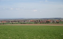
View of Lengde from the northern edge of the Harly Forest
|
||
Lengde is a district of the Lower Saxony city of Goslar in the district of Goslar .
geography
Lengde is located north of the Harly Forest at an altitude of 129 m above sea level. NHN and directly on the federal highway 36 . The district of Vienenburg is about 5.5 km south of Lengde, the center of Goslar about 14 km southwest. Lengde currently has around 600 inhabitants.
history
Place name
The name "Lengde" consists of the qualifier "lang" and the basic word "-de". The identifier is an outdated ending for abstract states (-heit, -e in "length"), which can be recognized in Old High German -ida and English -th (strength, wealth).
Incorporations
On July 1, 1972, Lengde was incorporated into the city of Vienenburg. On January 1, 2014, the city of Vienenburg was incorporated into the city of Goslar.
Population development
| development | year | Residents | source |
|---|---|---|---|
 |
|||
| 1950 | 1349 | ||
| 2011 | 670 | ||
| 2013 | 666 | ||
| 2014 | 633 | ||
| 2015 | 637 | ||
| 2016 | 601 | ||
| 2017 | 582 | ||
| 2018 | 580 |
politics
City Councilor and Mayor
At the local level Lengde is from the City Council represented from Goslar.
Mayor
The mayor of Lengde is Lisa Lindner ( SPD ). Her term of office runs from 2016 to 2021.
Personalities
Sons and daughters of the place
- Otto Fricke (1902–1972), entrepreneur and politician (CDU)
People connected to the place
- Helmut Krauss (1941–2019), actor and voice actor, lived in Lengde from 1978 until his death
See also
Web links
Individual evidence
- ↑ a b Federal Statistical Office (ed.): Official municipality register for the Federal Republic of Germany . Final results according to the September 13, 1950 census. Volume 33 . W. Kohlhammer Verlag, Stuttgart / Cologne August 1952, p. 61 , col. 2 ( digital version [PDF; 26.4 MB ; accessed on August 21, 2019] Landkreis Goslar, p. 70).
- ↑ a b c d e f Location data & statistics City of Goslar. In: Website city of Goslar. December 31, 2018, accessed May 26, 2019 .
- ^ Federal Statistical Office (ed.): Historical municipality directory for the Federal Republic of Germany. Name, border and key number changes in municipalities, counties and administrative districts from May 27, 1970 to December 31, 1982 . W. Kohlhammer, Stuttgart / Mainz 1983, ISBN 3-17-003263-1 , p. 270 .
- ↑ Lower Saxony State Chancellery (ed.): Law on the Unification of the Cities of Vienenburg and Goslar, District of Goslar . Lower Saxony Law and Ordinance Gazette (Nds. GVBl.). No. 10/2013 . Hanover June 19, 2013, p. 163 ( digitized version ( memento from September 26, 2018 in the Internet Archive ) [PDF; 153 kB ; accessed on August 21, 2019] p. 7).
- ↑ a b c The district of Goslar at a glance - figures, data, facts. In: Website of the district of Goslar. Retrieved August 21, 2019.
- ↑ Anke Donner: Local chiefs have been appointed. In: Website Regional Goslar. November 8, 2016, accessed August 25, 2019 .


