
Ahlem-Badenstedt-Davenstedt
| map | |
|---|---|

|
|
| Basic data | |
| Borough | Ahlem-Badenstedt-Davenstedt (11) |
| surface | 9.85 km² |
| Residents | 34,489 |
| Population density | 3501 inhabitants / km² |
| Post Code | 30453, 30455 |
| Districts |
|
| Web presence | hannover.de ( Memento from September 28, 2009 in the Internet Archive ) |
| politics | |
| District Mayor | Rainer Göbel (SPD) |
| Deputy District Mayor | Nolte-Vogt, Sabine (Alliance 90 / The Greens) |
| City District Council (19 seats) |
SPD: 7, CDU: 5 AfD: 2 Greens: 2 Left: 1 FDP: 1, Pirates: 1 |
Ahlem-Badenstedt-Davenstedt is the 11th district in Hanover . In 2015 it had 33,334 inhabitants and consists of the districts of Ahlem (10,566 inhabitants), Badenstedt (11,932 inhabitants) and Davenstedt (10,846 inhabitants).
Ahlem

The district of Ahlem is located in the north of the city district. It was initially an independent municipality and was incorporated into the city of Hanover on March 1, 1974.
Ahlem has had a partnership with the French municipality of Petit-Couronne in the Seine-Maritime department in Normandy since 1966 . There is a German-French student exchange at the Ahlem school center.
History of Ahlem
Ahlem emerged as a farming village under the protection of the castle of Count Konrad von Wunstorf . The fortified castle is mentioned in a document in 1187 as Castrum Limbere . Their exact location is no longer known today. It gave the Limmer settlement its name . Ahlem was ecclesiastically and economically in the shadow of the Limmer castle settlement. The village was first mentioned in documents in 1272 and 1288, when Ludolf and Johann von Roden bequeathed the Ahlemer Land to the Marienwerder monastery .
Ahlem was always rural, the villagers lived from agriculture. In 1770 the village had 120 inhabitants, about 100 years later in 1895 there were around 500. Rock containing asphalt was found around 1730, but it was not until the middle of the 19th century that it could be used economically. In 1897, the Ahlemer Turm excursion restaurant was built on a hill west of the village .
A street name today reminds of the former Herzogsborn .
Jewish house and concentration camp
After the November pogrom of 1938 , 15 Jewish houses were set up in Hanover , one of which was on the site of the former Ahlem Israelite Horticultural School . In September 1941, the city administration forced more than 1,000 Jews to move into one of the Jewish houses within a few hours . The Jews interned here were later deported to concentration camps in Eastern Europe. At the end of 1944, a satellite camp of the Neuengamme concentration camp , the Hanover-Ahlem concentration camp , was set up in Ahlem , to which inmates of the Stöcken concentration camp (Continental) were brought on the grounds of the Continentalwerk . It was located in today's Petit-Couronne-Strasse near the Ahlemer Höhe. The prisoners, mainly Polish Jews, were digging asphalt underground in a tunnel. A few days before the arrival of the US Army, the majority of the prisoners were sent on a death march to the Bergen-Belsen concentration camp. Those who remained in the camp were liberated on April 10, 1945.
Reminder and memorial
The Ahlem memorial and memorial has existed since 1987 on the site of the former Ahlem Israelite Horticultural School in the Justus von Liebig School. It essentially documents the history of this place as well as that of the inhabitants of the Jewish faith of the city of Hanover and the former district. Since 1994 a memorial has been commemorating the victims of the concentration camp.
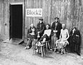
Concentration camp prisoners on April 11, 1945 in front of Barrack 2 in the Hanover-Ahlem satellite camp
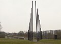
Ahlem asphalt shaft memorial at the site of the former concentration camp

Memorial at the former Ahlem Israelite Horticultural School


Today Ahlem includes the Ahlem primary school, a former school center that has been used temporarily by the city of Hanover as refugee accommodation since autumn 2014, the Ahlem city cemetery, the Ahlem memorial, the Evangelical Lutheran Martin Luther Church and the Catholic one Maria Trost Church , a Thai temple, the Justus von Liebig School for Floristry, Horticulture and Agriculture, the Dairy and Dairy Department of the Hanover University of Applied Sciences, the drug therapy facility House of Hope, the Plant Protection Office of the Lower Saxony Chamber of Agriculture and allotment gardens and Sports facilities.
Badenstedt

Badenstedt is located in the south of the city district. The oldest building was the Badenstedter Chapel , which was demolished in the 1920s . The population used to be characterized by a traditional working class environment due to its proximity to the large industrial areas of Linden , which is why there are many cooperative apartments here . The residential area northeast of Bornumer Holz (east of the freight bypass) is known as Körtingsdorf . The predecessor of the newer settlement near the Körting company is a workers' settlement that no longer exists today - built at the end of the 19th century. Only two workers' houses could be saved.
In the area of today's Badenstedt gymnastics club (TVB) there was a salt works founded by Georg Egestorff until the 20th century , in which large quantities of salt were extracted. In 1909 Badenstedt was incorporated into the city of Linden.
In addition to the TVB, there is another larger sports club, the Badenstedter Sportclub (BSC). Also located in Badenstedt is Jugend SV, which split off from the TVB in 1968 and wanted to maintain a youth-dominated sports culture.
In September 2001, a new market square was inaugurated at the Badenstedter monument, the central point of the district. In 2010, a well installed by the citizens' association and especially popular with children was built there. Nearby is the Evangelical Lutheran Paul Gerhardt Congregation, the old Badenstedter cemetery and opposite Badenstedter Straße the old village center with individual half-timbered houses that are well worth seeing. The Badenstedt-West development area has been under construction directly on Benther Berg since the mid-1990s .

Badenstedt has two primary schools (Gebrüder-Körting-Schule, Friedrich-Ebert-Schule). A special needs school for people with learning disabilities (Astrid Lindgren School) moved in summer 2013 and left the district. The Badenstedt school center is located on Plantagenstrasse. A primary school has been located in this traditional school building since 1909. With the additions in 1953 and 1976, the premises were supplemented and used by the secondary school and secondary school in Badenstedt, the orientation level and the school for the hard of hearing as well as a branch of the Helene-Lange-Schule. The IGS Badenstedt has been the only school in the building since 2015. The district library is also located here.
The Plantage Kulturtreff is also located in the school center on Plantagenstrasse. Another cultural institution are the former Fuchswerke near the border with Empelde . Numerous workshops, studios, companies, shops have settled here after an exemplary renovation of the former factory. The company Viscom , one of the largest employers in the district, has set up shop in Badenstedt's industrial park .
The Catholic Christ the King Church was consecrated in 1965, and there is also a New Apostolic Church in Badenstedt. The Sri Muthumariamman Temple, the largest North German Hindu temple , has been located in an industrial park since 2009 .
The Fosse flows like a border river between Badenstedt and the northern neighboring district of Davenstedt.
Davenstedt


Davenstedt is located in the middle of the city district. In the Davenstedt market area there are modern rental and owner-occupied apartments, and in Davenstedt-West there is a large terraced housing estate built in the early 1980s. A monument of modern architecture is the terrace high-rise built in 1973 on Wegsfeld Street, popularly it is either compared to the ancient Hanging Gardens of Babylon or referred to as the battleship. In Davenstedt-Ost on Davenstedter Straße is the building of the Davenstedt volunteer fire department.
Davenstedt was first mentioned as Davenstide in Marstemgau in 1022 in a deed of foundation of the Hildesheim Michaeliskloster issued by Emperor Heinrich II , the authenticity of which has been questioned by some historians. A second mention in church registers as Davenstede situm in 1280 is beyond dispute. In 1909 Davenstedt was incorporated into the city of Linden.
In the old village center is the St. Johannes Chapel from 1790, one of the two preserved Hanoverian half-timbered chapels next to the Wülferode chapel . Nearby is the new brick St. Johannes building in a park-like area connected to the kindergarten, community hall, sexton and pastor's house.
The TuS Davenstedt sports club has its premises near the former community forest Davenstedter Holz on Geveker Kamp. Apart from the street of the same name, only a short stream with trees remains of Davenstedter Holz. In the northeast of Davenstedt is the primary school In der Steinbreite .
District Council
In the local elections on September 23, 2016 , the SPD was again the strongest party in the district with 34.4% (7 seats) of the vote and is the new district mayor, Rainer Göbel. Sabine Nolte-Vogt (Greens) was elected Deputy District Mayor . The second strongest party was again the CDU (5 seats) with 25.8%. The AfD (2 seats) with 12.12% is new in the district council. The district council of Ahlem-Badenstedt-Davenstedt meets about eight times a year in public in the community center in Ahlem.
Personalities
- Auguste Breitzke (* 1908; † 1982), social democratic resistance fighter
traffic
Ahlem-Badenstedt-Davenstedt is located on the Hanover freight bypass . The Ahlem depot is located there .
See also
Web links
- City district portal Ahlem-Badenstedt-Davenstedt
- Structural data of the city districts and districts of Hanover as of 2020, a publication of the city of Hanover
Individual evidence
- ↑ Structural data 2017 of the city of Hanover p. I-8 (PDF, accessed on September 29, 2017)
- ↑ Information on the district council at www.hannover.de , accessed on September 27, 2017
- ^ Federal Statistical Office (ed.): Historical municipality directory for the Federal Republic of Germany. Name, border and key number changes in municipalities, counties and administrative districts from May 27, 1970 to December 31, 1982 . W. Kohlhammer, Stuttgart / Mainz 1983, ISBN 3-17-003263-1 , p. 189 .
- ↑ hannover.de: Ahlem Memorial ( Memento from April 18, 2009 in the Internet Archive )
- ↑ hannover.de: A tour through Ahlem ( Memento from August 2, 2012 in the web archive archive.today )
- ↑ Klaus Mlynek, Waldemar R. Röhrbein (ed.): Hanover Chronicle: From the beginnings to the present , figures • data • facts, Schlütersche, Hanover 1991
- ^ Hector Wilhelm Heinrich Mithoff: Art monuments and antiquities in Hanover. First volume: Fürstenthum Calenberg , Helwingsche Hofbuchhandlung, Hanover 1871, p. 24 digital copy , accessed on March 11, 2015.
- ↑ Hannoversche Allgemeine Zeitung of November 29, 2011, p. 13
Coordinates: 52 ° 22 ′ N , 9 ° 40 ′ E