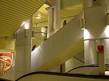
Kröpcke underground station
The Kröpcke underground station is the most important underground station for the Hanover city railway . It is named after the central square in the Hanoverian pedestrian zone Kröpcke in the Mitte district . This is where the A, B and C lines of the light rail cross. The trains of lines 1 to 9 and 11, the night star traffic line 10 ( deleted line ) and the demand lines 16 and 18 stop at six platforms 000 people out, in or around.
history
Construction of the Kröpcke station began in the early 1970s. On September 26, 1975, the platforms of the A route were opened. Initially only the first tram line 12 (Oberricklingen - Hauptbahnhof ) ran here . On April 4, 1976, the complete A-route was opened, now lines 3 (Oberricklingen – Lahe) and 7 (Oberricklingen – Fasanenkrug) operated. The station was opened in the course of the advancing light rail construction in further sections: On May 27, 1979 the platforms of the B line were opened and on September 26, 1982 the platforms of the C line were put into operation.
Initially, the Üstra operations control center was located in the station . This has now been relocated to the Glocksee depot.
The station was completely renovated on the occasion of the Expo 2000 in 1999. Elevators were installed so that all platforms were accessible without barriers. In addition, according to a design by the Italian designer Massimo Iosa Ghini , the walls were given a 12 000 square meters of glass mosaic surface consisting of green and yellow glass stones was redesigned.
Since 2001 the infrastructure company Region Hannover has owned the Hanover subway stations.
From July 2013, the elevator on the platform of the A route for trains traveling west (Empelde, Wettbergen) was extended, so that it does not only extend to the −1 level of the Niki-de-Saint-Phalle-Promenade as before , but to the street level of the Kröpcke. The elevator should be operational again by the end of October 2013. To prevent the elevator from being parked and e.g. B. is not accessible for wheelchair users, it was secured with bollards.
description
The station is the deepest in the Hanover network. It contains the four longest escalators in Hanover. With a length of about 33 each m lead them from the distribution level (−1) to the two platforms of the C line (−4).
- Level −1
- Access level and transition to the Niki-de-Saint-Phalle-Promenade
- Level −2
- A route (lines 3, 7 and 9): one side platform each in the direction of the main train station and market hall / state parliament , under Karmarschstrasse
- B-route (lines 1, 2, 8 and 18): one side platform each towards the main train station and Aegidientorplatz , under Georgstraße
- Level transition between the A lines towards the main station and the B lines towards Aegidientorplatz
- Level -3
- Distribution level with entrances and exits to the platforms of the A, B and C routes.
- Level -4
- C-route (lines 4, 5, 6, 11 and 16): one side platform each in the direction of Steintor and Aegidientorplatz below the platforms of the B-route.
There are no connecting tracks between the individual lines at the Kröpcke station. The next connections are at the Hauptbahnhof station between the A and B lines and at the Aegidientorplatz station between the B and C lines.
On the C-route leading to the west, there is a single-track sweeping system behind the platform . The sweeping track was originally intended as a connecting track between the C and the unrealized D route . It should enable company trips to the Glocksee depot. The sweeping system enables trains coming from the south to turn. It is not required in regular operation.
Lines
literature
- Horst Moch: Tram in Hanover. Kenning Verlag, Nordhorn 2004, ISBN 3-933613-45-0 .
Web links
Individual evidence
- ↑ https://www.uestra.de/auskunft-und-fahrplaene/liniennetz
- ↑ GVH Stadtbahn 2014 ( Memento of the original from November 17, 2015 in the Internet Archive ) Info: The archive link was inserted automatically and has not yet been checked. Please check the original and archive link according to the instructions and then remove this notice. (PDF; 1.88 MB)
- ↑ Üstra press release of July 8, 2013 ( memento of the original of September 9, 2013 in the Internet Archive ) Info: The archive link was automatically inserted and not yet checked. Please check the original and archive link according to the instructions and then remove this notice.
- ↑ http://www.verkehrsag-hannover.de/35.html
Coordinates: 52 ° 22 ′ 28 ″ N , 9 ° 44 ′ 19 ″ E

