
Königsworther Platz

The King Platz is a square and a busy road intersection in Hanover district center on the border of the districts Calenberger Neustadt and North City . It is the central junction for traffic to and from the West Schnellweg in the form of federal highway 6 . The Bremer Damm ( Landesstrasse 190 ), which has been elevated in some places, serves as a feeder that connects to the west of the square. The Königsworther Platz distributes the incoming traffic on the Cityring in the east to the main station , in the southeast over the Leibnizufer in the direction of Waterlooplatz and in the southwest over the Königsworther Strasse in the direction of Linden-Nord and- Mitte .
description
Facing Schloßwender Strasse, the 15-story Conti high-rise was built in 1952/53 on the site of the Uhlan barracks destroyed in World War II , the former headquarters of Continental AG . The building designed by Ernst Zinsser was the tallest skyscraper in Germany at the time . Today it is used by the University of Hanover . On the opposite side of the square, IG Bergbau, Chemie, Energie has built its German headquarters; in the south, the square is dominated by an Allianz SE high-rise . To the north, the square opens to the Georgengarten and the main building of the University of Hanover, the Welfenschloss in the Welfengarten . This is where the Hanover Sculpture Mile begins , which continues at around 1,200 m southwards to the Lower Saxony State Parliament .

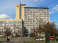
Conti high-rise as one of the dominant structures on the square, today a university

The Bremer Damm, which is partially elevated at the level of the Center for University Sports at Leibniz University, serves as a feeder to the Westschnellweg (B 6) and begins at the square

Beginning of the Hanover Sculpture Mile on the square with a work by John Raymond Henry

Bus shelter from BUSSTOPS at the square


history
The square was named after the town of Königsworth , which once stretched between Brühlstrasse in the east and the Leine in the west. The square was created in the middle of the 19th century as a parade ground for the cavalry barracks No. IX, which later became the Ulan barracks . A similar military-related method of origin is the case in Hanover at Welfenplatz and Waterlooplatz .
In the time of National Socialism , Königsworther Platz was often the target of marches, because the local party headquarters was only a few steps away. The rulers at the time renamed the place Horst-Wessel- Platz and confirmed this by planting an oak. After the Second World War, these traces were removed and the old name restored.
Uhlan barracks

A first forerunner of the barracks on Königsworther Platz was a sovereign mule stable in 1736 , which became a barracks building after the Seven Years' War (1756–63). The Garde du Corps regiment was stationed there. From around 1840 a larger barracks complex was built. The barracks area was located between the Neustädter Friedhof , which at that time was still called St. Andreas Kirchhof, and Schloßwender Straße on the site of the later Conti high-rise, today Leibniz University of Hanover . The barracks had three residential buildings about 20, 40 and 50 m in length. The long sides of the buildings faced the square. They were brick buildings on a sandstone base . The team rooms were occupied by an average of about 10 men. Each housed soldier had about 20 m³ of space available. Three elongated stables for around 400 horses extended deep into the property. Other outbuildings were a blacksmith's shop, riding school and hospital stables. After the annexation of the Kingdom of Hanover by Prussia in 1866, the complex became the Uhlan barracks, in which the King's Uhlan Regiment No. 13 was stationed. The barracks were destroyed in the air raids on Hanover during the Second World War . The undestroyed gate portal, which was created by Johann Paul Heumann in 1736 , was rebuilt in 1955 in front of the municipal building authorities, today's department of planning and urban development, near the new town hall on Friedrichswall. Today it is a listed building .

The square around 1855; Engraving from Thümling to Kretschmer
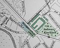
Plan of the square 1896 with Uhlan barracks (green)

Königsworther Platz around 1890, the Ulanenkaserne on the right
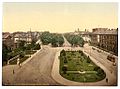
Königsworther Platz around 1895, in the background the Welfenschloss

Portal of the former Garde du Corps barracks on Königsworther Platz from 1736, today on Rudolf Hillebrecht Platz near the New Town Hall


.jpg&filetimestamp=20070427164716&)

Metro station

The subway station of the same name on the C-line of the Stadtbahn is located under Königsworther Platz . The trains of line 4 (Garbsen – Roderbruch) and line 5 (Stöcken – Anderten) stop here. To the west of the station, a ramp leads the route to the surface. Under this ramp there is a double-track sweeping system , which is not used in normal regular traffic. It is the end point of event line 16.
On one side of the square there is a bus stop for bus route 100. It was equipped with a futuristic bus stop by Ettore Sottsass as part of the art project BUSSTOPS .
literature
- Hinrich Ewert, Holger Horstmann: Restless days in a provincial capital. March 1920 between Königsworther Platz and Herrenhäuser Allee , in Adelheid von Saldern et al. : Everyday life between Hindenburg and Haarmann. Another city guide through Hanover in the 20s , publisher: Geschichtswerkstatt Hannover, Hamburg: VSA-Verlag, 1987, ISBN 3-87975-397-0 , pp. 83-88
Web links
Coordinates: 52 ° 22 ′ 43 " N , 9 ° 43 ′ 20" E