Graitschen on the heights
|
Graitschen on the heights
City of Schkölen
Coordinates: 51 ° 2 ′ 42 ″ N , 11 ° 47 ′ 8 ″ E
|
||
|---|---|---|
| Height : | 277 m above sea level NN | |
| Incorporation : | January 1, 1997 | |
| Postal code : | 07619 | |
| Area code : | 036694 | |
|
Location of Graitschen on the heights in Thuringia |
||
Graitschen auf der Höhe is a district of the town of Schkölen in the Saale-Holzland district in Thuringia .
Geography and geology
Graitschen is located directly on the state border with Saxony-Anhalt . The neighboring village in Saxony-Anhalt is Molau . Graitschen is therefore also on the Molauer plate, which is known for its black earth-like soils and predominantly field cultivation, because there are hardly any wooded groves . Some sand and gravel pits disturb the farmer. With a local connecting road, the citizens and the companies have a connection to the state road 201 from Schkölen to Naumburg and Eisenberg and thus to the federal motorway 9 .
history
The first documentary mention took place on July 21, 1040. The old Regensburger Strasse once led through the town to Naumburg. That is why the village was also the blacksmith's village.
Graitschen belonged to the Wettin district office in Eisenberg , which was under the sovereignty of various Ernestine duchies due to several divisions in the course of its existence . In 1826 the place came with the northern part of the Eisenberg district office from the Duchy of Saxony-Gotha-Altenburg to the Duchy of Saxony-Meiningen and became part of the Camburg exclave. From 1922 to 1939 the place belonged to the Camburg district department . In 1924, the place received the postal attachment on the height (official municipality name: Graitschen ad Höhe ) in order to avoid confusion with the Graitschen of the same name near Bürgel .
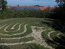
The natural monument Trojaburg or "Schwedenhieb" is a lawn maze that goes back to the Thirty Years' War or even prehistory.
On July 1, 1950, the previously independent municipality Grabsdorf was incorporated.
In 1997 the community of Graitschen ad Höhe was incorporated into Schkölen.
Attractions
- Village church Graitschen on the heights
- Troy Castle
Individual evidence
- ^ Wolfgang Kahl : First mention of Thuringian towns and villages. A manual. 5th, improved and considerably enlarged edition. Rockstuhl, Bad Langensalza 2010, ISBN 978-3-86777-202-0 , p. 97.
- ↑ Graitschen on the website of the city of Schkölen
- ↑ Michael Köhler: Pagan sanctuaries. Pre-Christian places of worship and suspected cult sites in Thuringia. Jenzig-Verlag Köhler, Jena 2007, ISBN 978-3-910141-85-8 , p. 232.


