Dothen
|
Dothen
Schkölen municipality
Coordinates: 51 ° 0 ′ 39 ″ N , 11 ° 49 ′ 22 ″ E
|
||
|---|---|---|
| Height : | 279 m above sea level NN | |
| Incorporation : | January 1, 1997 | |
| Postal code : | 07619 | |
| Area code : | 036694 | |
|
Location of Dothen in Thuringia |
||
|
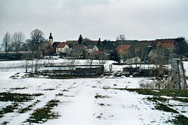
View of the place
|
||
Dothen with its districts of Launewitz and Willschütz , Poppendorf and Tünschütz is a district of the town of Schkölen in the Saale-Holzland district in Thuringia .
Geography and geology
To the south of Schkölen, the old church village of Dothen lies on an arable plain with loosened black earth-like soils. Only a few flat valleys with streams and hollows bear trees or woody plants. The soil is too fertile to be used otherwise. The place is west of the Wethau .
With local roads, citizens and businesses are connected to the state roads 1070 and 1071, which pass in the immediate vicinity, and also to the federal motorway 9 . The traffic connection to Schkölen is optimal. In general, these statements also apply to the districts of Dothen because they all have a similar environment.
history
The first documentary mention of Dothen took place in 1261. The church is the oldest in the unified congregation. The place is a Slavic round village and is still well preserved in this form. The former school building, which was in use for a long time, dates from 1350.
Originally, the Tautenburg taverns were masters of the place. After this noble family died out, the place belonged to the Electoral Saxon Office of Tautenburg from 1640/52 . With the Congress of Vienna in 1815, the place became part of the Grand Duchy of Saxony-Weimar-Eisenach and in 1822 it was incorporated into the Bürgel and Tautenburg office. In 1850 the place came to the administrative district Weimar II (from 1868: administrative district Apolda ) of the Grand Duchy. Dothen has been part of the state of Thuringia since 1920.
There is a riding stables in the village. An ecological organic farm also works successfully. Other farmers use the new forms of cooperation in the area. The Dothener are also known for their meat and sausage products.
Web links
Individual evidence
- ^ Wolfgang Kahl : First mention of Thuringian towns and villages. A manual. 5th, improved and considerably enlarged edition. Rockstuhl, Bad Langensalza 2010, ISBN 978-3-86777-202-0 , p. 60.
- ↑ Dothen on the website of the city of Schkölen.Retrieved on October 6, 2017.
- ^ Karlheinz Blaschke , Uwe Ulrich Jäschke : Kursächsischer Ämteratlas 1790. Scale approx. 1: 200000. Gumnior, Chemnitz 2009, ISBN 978-3-937386-14-0 , p. 34 f.
- ↑ Bürgel at www.geo.viaregia.org
- ↑ Geographical overview of the Saxon-Ernestine, Schwarzburg, Reussian and adjacent lands. Perthes, Gotha 1826, p. 53 .
- ↑ Locations of the administrative district Apolda in the municipality register 1900

